
Lamport Road, Orton, Kettering, NN14
- PROPERTY TYPE
Plot
- SIZE
3,000 sq ft
279 sq m
Key features
- Fully consented stone barns, garage foundations implemented
- 2.25 acres est.
- Paddock & Pond
- A14 Junction 3 - 2 miles
- Kettering train station - 7 miles
- Market Harborough train station - 8 miles
Description
Situation
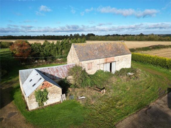
Just under 2 miles from Junction 3, the Victorian stone barns and former crew yard are set at the rear of the Harrington Lodge yard, beside the paddock and pond.
Plot
With a total plot size of 2.25 acres est. The boundary ownership is shown with an inward facing ‘T’.
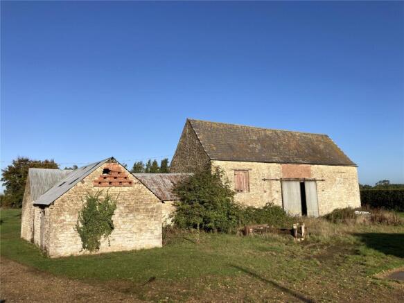
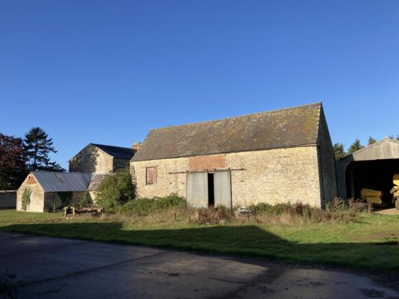
The Stone Barns
The Barns themselves give 2,918 sq.ft. of house and annexe, with garage and a store above. The permanent pasture paddock leads to the pond and island.
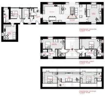
With consent for conversion into a 3-storey house to include 4 bedrooms; 3 ensuite, master bathroom, 2 reception rooms, kitchen and a single storey annexe to include guest living/dining room, kitchen, bedroom and bathroom, and demolition of the portal frame barn.
Planning
Application KET/2020/0710 | North Northamptonshire Council - Kettering Area
Property Information Pack
Additional draft information is available. Architect’s tender designs, the planning decision notice, drainage plans, structural plans.
Method of Sale & Tenure
The Freehold of the property is for sale by Private Treaty with vacant possession on completion.
Access
The property will have rights of access at all times for a single residence and annexe, shown hatched brown on the map. There are no public rights of way across the land.
Local Authority
North Northamptonshire Council
Registered Title
NN355722..
Services
The site has electricity. The vendors are renewing the water supply. The foul will require a treatment plant (see plans).
Viewing
Viewing by appointment only.
GPS Location Search
clarifies.convenants.storm (what3words.com)
Situation
Just under 2 miles from Junction 3, the Victorian stone barns and former crew yard are set at the rear of the Harrington Lodge yard, beside the paddock and pond.
Plot
The boundary ownership is shown with an inward facing ‘T’.
The Stone Barn
The Barns themselves give 2,918 sq.ft. of house and annexe, with garage and a store above. The permanent pasture paddock leads to the pond and island. With consent for conversion into a 3-storey house to include 4 bedrooms; 3 ensuite, master bathroom, 2 reception rooms, kitchen and a single storey annexe to include guest living/dining room, kitchen, bedroom and bathroom, and demolition of the portal frame barn.
Planning
The garage footings have been put in. Application KET/2020/0710 | North Northamptonshire Council - Kettering Area
Method of Sale & Tenure
The Freehold of the property is for sale by Private Treaty with vacant possession on completion.
Access
The access is owned and includes a part demolished barn at the entrance.
Local Authority
North Northamptonshire Council.
Registered Title
NN355722.
Services
The site has electricity in the drive. The vendors are renewing the mains water supply. The foul will require a treatment plant (see plans).
GPS Location Search
clarifies.covenants.storm (what3words.com)
Property Information Pack
Additional draft information is available. Architect’s tender designs, the planning decision notice, drainage plans, structural plans.
Brochures
ParticularsLamport Road, Orton, Kettering, NN14

NEAREST STATIONS
Distances are straight line measurements from the centre of the postcode- Kettering Station5.2 miles


Notes
Disclaimer - Property reference KET220012. The information displayed about this property comprises a property advertisement. Rightmove.co.uk makes no warranty as to the accuracy or completeness of the advertisement or any linked or associated information, and Rightmove has no control over the content. This property advertisement does not constitute property particulars. The information is provided and maintained by Berrys, Kettering. Please contact the selling agent or developer directly to obtain any information which may be available under the terms of The Energy Performance of Buildings (Certificates and Inspections) (England and Wales) Regulations 2007 or the Home Report if in relation to a residential property in Scotland.
Map data ©OpenStreetMap contributors.