Land at Glendouglas, Jedburgh
- PROPERTY TYPE
Land
- SIZE
Ask agent
Description
* Development potential for residential or leisure facilities
* Excellent Location with good transport links
* For sale by private treaty with vacant possession
Description
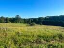
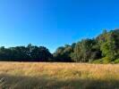
The land extends to 12.16 acres or thereabouts, comprising of approximately 5.75 acres of amenity woodland, including a range of native and non-native trees of varying ages, and approximately 6.41 acres of grassland. The land was previously intended for a leisure development consisting of a number of holiday chalets.
Situation
The property is located approximately 2 miles south of the centre of Jedburgh in the county of Roxburghshire and is adjacent to the A68 truck road, providing excellent vehicular transport links, including to Newcastle airport, which is approximately 52 miles south whilst Edinburgh airport lies approximately 54 miles north.
Jedburgh is steeped in history with a great many attractions including the 12th century Augustinian Abbey, Jedburgh Jail and Museum and Mary Queen of Scots' house. As such the area benefits from a significant level of seasonal tourist trade. The town is positioned to the south of the Scottish Borders close to Jed Water a tributary of the River Teviot, approximately 10 miles to the north of the border with England.
Location
What3words ///choice.wink.quietest
Planning Permission
Planning was previously granted for the erection of up to 15 holiday chalets, a site office, car parking, and landscaping works. This permission has now lapsed but can be reviewed on the Scottish Borders Council Online Planning Portal using the reference 15/00106/AMC. Any future development of the site may be subject to an Overage Agreement.
Offers
Written offers should be submitted to the Selling Agents.
Brochures
BrochureLand at Glendouglas, Jedburgh
NEAREST STATIONS
Distances are straight line measurements from the centre of the postcode- Tweedbank Station13.6 miles


Notes
Disclaimer - Property reference RS0195. The information displayed about this property comprises a property advertisement. Rightmove.co.uk makes no warranty as to the accuracy or completeness of the advertisement or any linked or associated information, and Rightmove has no control over the content. This property advertisement does not constitute property particulars. The information is provided and maintained by Edwin Thompson, Berwick-Upon-Tweed. Please contact the selling agent or developer directly to obtain any information which may be available under the terms of The Energy Performance of Buildings (Certificates and Inspections) (England and Wales) Regulations 2007 or the Home Report if in relation to a residential property in Scotland.
Map data ©OpenStreetMap contributors.


