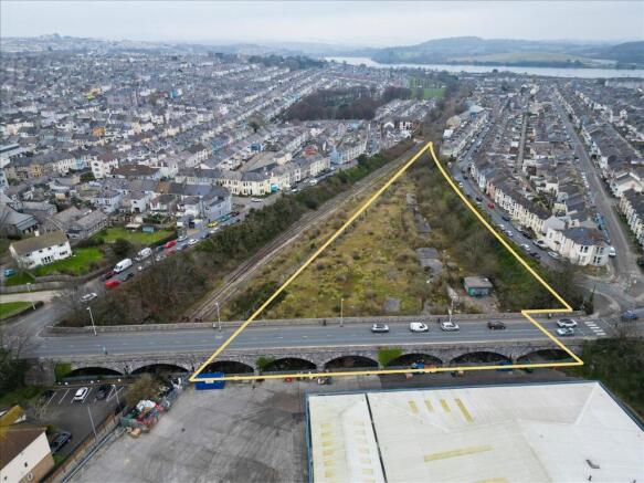
Land, South Of Knighton Road, Plymouth, Devon, PL4
£6.33 per sq ft
Business rates & charges may apply

- SIZE AVAILABLE
142,266 sq ft
13,217 sq m
- SECTOR
Residential development for sale
Key features
- Area - Plymouth
- Size - 142,266 sqft (3.2 acres)
- Local Amenities - Tottill Park (0.1 miles), Plymouth town centre (0.4 miles), Friary Retail Park (0.5 miles)
- Property Type - Land with development potential
- Planning History - Previously approved for 50 dwellings to be built
Description
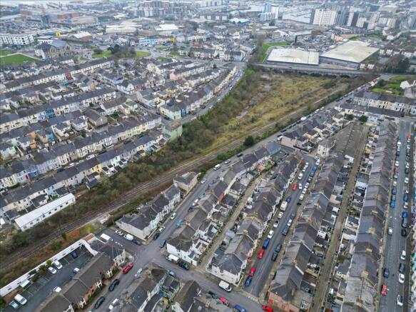
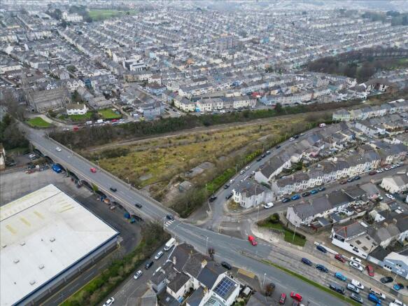
The land measures approximately 3.2 acres (1.3 hectares) and is not designated as greenbelt or part of an Area of Outstanding Natural Beauty (AONB), allowing for greater flexibility in development. In 2017, the site received outline planning consent for the construction of 50 residential dwellings, demonstrating its potential for residential development.
Currently, the site is accessed via a neighbouring property under Tothill Bridge, with the possibility of establishing a new access route from Desborough Road, enhancing connectivity and access options.
With its central location, close proximity to retail and commercial services, and excellent transport links, this site represents a prime opportunity for redevelopment.
The land to the south of Knighton Road in Plymouth is located in a residential area with good transport links and access to local amenities. The site is approximately 1 mile from the city centre, where a wide range of shops, restaurants, and services are available. Local schools are within easy reach. Public transport options are plentiful, with Plymouth Railway Station located around 1.5 miles away, offering direct services to destinations such as Exeter, Bristol, and London Paddington. The A38, which is also nearby, provides quick access to the M5 motorway, allowing convenient travel to Exeter (approximately 45 miles east) and Cornwall (via the A30). Major supermarkets such as Tesco, Sainsbury's, and Morrisons are within a short distance, offering convenient shopping options. Green spaces, including Central Park (approximately 1 mile away), provide recreational opportunities, while the waterfront and coastal locations are easily accessible for outdoor activities.
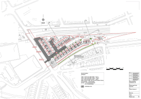
The land lying to the south of Knighton Road, formerly known as Tothill Sidings, has significant development potential and has had a number of planning applications submitted over the years.
It’s most recent planning approval was granted in 2017, for outline planning for 50 dwellings to be built, under the reference
16/01422/REM.
This residential development included a range of houses:
10 x 3 bed houses @ 91.58 sqm
39 x 4 bed houses @ 103.88 sqm
1 x 4 bed house @ 123.39 sqm
Within the scheme there were also 8 affordable housing units. A total of 96 car parking spaces were planned, including 57 on-plot spaces and 39 integral garages.
This application has since lapsed and will need to be re-submitted for the council's review.
Brochures
Land, South Of Knighton Road, Plymouth, Devon, PL4

NEAREST STATIONS
Distances are straight line measurements from the centre of the postcode- Plymouth Station0.9 miles
- Devonport Station2.0 miles
- Dockyard Station2.3 miles
Notes
Disclaimer - Property reference LON000928. The information displayed about this property comprises a property advertisement. Rightmove.co.uk makes no warranty as to the accuracy or completeness of the advertisement or any linked or associated information, and Rightmove has no control over the content. This property advertisement does not constitute property particulars. The information is provided and maintained by Whozoo, London. Please contact the selling agent or developer directly to obtain any information which may be available under the terms of The Energy Performance of Buildings (Certificates and Inspections) (England and Wales) Regulations 2007 or the Home Report if in relation to a residential property in Scotland.
Map data ©OpenStreetMap contributors.