Land on the South Side of Station Road, Ashwell, Baldock, Hertfordshire
- SIZE AVAILABLE
766,656 sq ft
71,225 sq m
- SECTOR
Land for sale
Key features
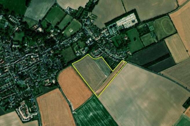
- The Property benefits from frontage onto Station Road
- Property comes under the planning jurisdiction of North Hertfordshire Council
- Unconditional offers are sought for the freehold interest with vacant possession
- Viewings strictly only by appointment through Savills Cambridge
Description
The Property is located on the eastern edge of the village of Ashwell, a village in North Hertfordshire, approximately 6.6 km(4.1 miles) north of Baldock, 8.1 km (5.1 miles) west of Royston and 9.9 km (6.1 miles) south east of Biggleswade. The village is considered sustainable,comprising a single form entry primary school, village hall, museum, three public houses, nursery and recreational playing grounds. The Property benefits from frontage onto Station Road. Station Road links to Station Road which runs south from Steeple Morden to the A505, which links to the M11 to the north and A1 (M) to the south.
Brochures
Land on the South Side of Station Road, Ashwell, Baldock, Hertfordshire

NEAREST STATIONS
Distances are straight line measurements from the centre of the postcode- Ashwell & Morden Station1.6 miles
- Baldock Station3.7 miles
- Royston Station5.1 miles
Notes
Disclaimer - Property reference 40C5C686-A5AD-480A-BCAD-DCEFBBC95C57. The information displayed about this property comprises a property advertisement. Rightmove.co.uk makes no warranty as to the accuracy or completeness of the advertisement or any linked or associated information, and Rightmove has no control over the content. This property advertisement does not constitute property particulars. The information is provided and maintained by Savills, Cambridge. Please contact the selling agent or developer directly to obtain any information which may be available under the terms of The Energy Performance of Buildings (Certificates and Inspections) (England and Wales) Regulations 2007 or the Home Report if in relation to a residential property in Scotland.
Map data ©OpenStreetMap contributors.