Douglas Avenue, Bold, St Helens
- PROPERTY TYPE
Land
- BEDROOMS
4
- BATHROOMS
1
- SIZE
Ask agent
Key features
- For Sale by Modern Auction – T & C’s apply
- Approximately 0.9 Hectares (ha) in Size
- Land is Now Considered to be ‘White Land’
- Rural Location, With Open Fields to the North and West
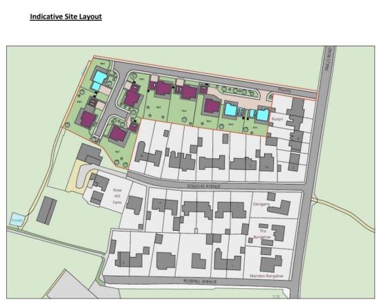
- Development Proposed is the Build of Approximately Nine Dwellings
- Potentially Three 4-Bedroom Houses and Six 5-Bedroom Houses
- Pre-Application Enquiry Completed
- Subject to Reserve Price & Buyers fees apply
- The Modern Method of Auction
- Call Now for Further Details
Description
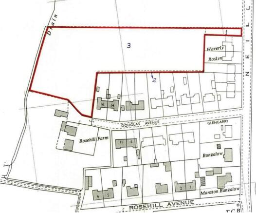
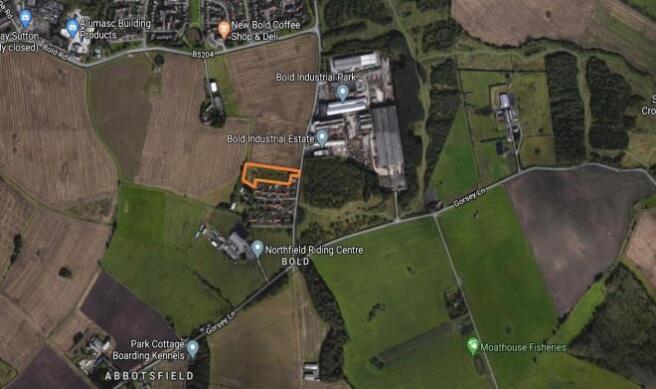
Site Details - The Site extends 0.90 ha (2.23 acres) and is located in Bold, approximately 4km south east of St Helens town centre. The site comprises an ‘L’ shaped parcel of land which wraps around the rear of the dwellings along the north of Douglas Avenue. The site stretches east to west with a narrow access road connecting to Neills Road to the east and the parcel wrapping around the dwellings and connecting to Rose Hill Farm to the south west. There are a small
number of trees within the site and some larger trees scattered along boundary edges amongst hedgerows. The site is contained by open and flat agricultural fields to the north and west, whilst the east and south is contained by residential dwellings and the south west is Rose Hill Farm. The site appears generally flat with views north and north west into the flat open agricultural fields. Douglas Avenue is a small hamlet of dwellings west of Neills Road with
Bold Industrial Park to the north east and Rosehill Avenue further south which is another small road providing access for a small number of residential dwellings.
Site Access - The site currently benefits from access to Neill’s Road with sufficient width to accommodate a private driveway to serve a small number of units. As per the extract from St Helens Highways for Adoption 4.12 (right), the minimum requirement for the full width of the access would be 6.9m which can be provided within the site boundary. It is therefore proposed that a 4.5m wide road, 2m wide footpath and a 0.5 service strip be provided, giving a total width of 7m carriageway construction.
Public Transport - The site is adjacent to bus stops situated along Neills Road where services 39, 141 and 755 stop. Hourly services run in both directions towards St Helens to the north and Earlestown or Vulcan Village to the south. The St Helens Junction rail station is situated a 1.8km walk north west of the site and provides hourly services to both Liverpool Lime Street and Manchester Airport.
Shops And Services - There are limited shops and services within walking distance of the site. Wades Once Stop Convenience Store is an 800m walk north of the site. The convenience store is within a small parade of shops which includes a café and salon.
Station Road is a 1.8km walk north west of the site in Sutton and provides a wider range of services including Sutton Oak Post Office, numerous cafes and a convenience store. There is also an Aldi situated at Marshalls Cross, a 3.7km walk from the site.
Education - There are a small number of primary schools within circa 1.8km of the site. These include St Anne’s Catholic Primary School (Ofsted rating 3- requires improvement), Sutton Oak C of E Primary School (Ofsted rating 2- Good), St Paul of the Cross Catholic Primary School (Ofsted rating 2- Good) and Burtonwood Community Primary School (Ofsted rating 1- Outstanding). St Curtbert’s High School (Ofsted rating 2- Good).
Employment - Bold Industrial Estate is a 100m walk north east of the site where there is a range of industrial and commercial business. Furthermore, Reginald Road Industrial Estate is to the west of the site and is a 1.6km walk. This industrial estate hosts a broad range of business including Springfield Modular, Foodpack and Brave Design- a bedroom furniture store. Within 2km of the site there are other smaller employers including restaurants and bars (The Wheatsheaf, The Clock Face Pub and Restaurant and Station House Café), Burtonwood Brewery, Newbold Convenience Store and many other small businesses. There is a healthy presence of employment opportunities within a sustainable distance of the site. Furthermore, the sites association with the St Helens Junction rail station shows the sites strong connectivity with other urban centres including Manchester and Liverpool.
Auctioneer Comments - This property is for sale by Modern Method of Auction allowing the buyer and seller to complete within a 56 Day Reservation
Period. Interested parties’ personal data will be shared with the Auctioneer (iamsold Ltd).
If considering a mortgage, inspect and consider the property carefully with your lender before bidding. A Buyer Information
Pack is provided, which you must view before bidding. The buyer is responsible for the Pack fee. For the most recent
information on the Buyer Information Pack fee, please contact the iamsold team.
The buyer signs a Reservation Agreement and makes payment of a Non-Refundable Reservation Fee of 4.5% of the purchase
price inc VAT, subject to a minimum of £6,600 inc. VAT. This Fee is paid to reserve the property to the buyer during the
Reservation Period and is paid in addition to the purchase price. The Fee is considered within calculations for stamp duty.
Services may be recommended by the Agent/Auctioneer in which they will receive payment from the service provider if the
service is taken. Payment varies but will be no more than £960 inc. VAT. These services are optional.
Brochures
Douglas Avenue, Bold, St HelensBrochureDouglas Avenue, Bold, St Helens

NEAREST STATIONS
Distances are straight line measurements from the centre of the postcode- St Helens Junction Station0.8 miles
- Lea Green Station1.7 miles
- Earlestown Station2.4 miles
About John Brown Estate Agents, St Helens
14 Claughton Street, St. Helens, WA10 1RS


Notes
Disclaimer - Property reference 33785447. The information displayed about this property comprises a property advertisement. Rightmove.co.uk makes no warranty as to the accuracy or completeness of the advertisement or any linked or associated information, and Rightmove has no control over the content. This property advertisement does not constitute property particulars. The information is provided and maintained by John Brown Estate Agents, St Helens. Please contact the selling agent or developer directly to obtain any information which may be available under the terms of The Energy Performance of Buildings (Certificates and Inspections) (England and Wales) Regulations 2007 or the Home Report if in relation to a residential property in Scotland.
Auction Fees: The purchase of this property may include associated fees not listed here, as it is to be sold via auction. To find out more about the fees associated with this property please call John Brown Estate Agents, St Helens on 01744 903766.
*Guide Price: An indication of a seller's minimum expectation at auction and given as a “Guide Price” or a range of “Guide Prices”. This is not necessarily the figure a property will sell for and is subject to change prior to the auction.
Reserve Price: Each auction property will be subject to a “Reserve Price” below which the property cannot be sold at auction. Normally the “Reserve Price” will be set within the range of “Guide Prices” or no more than 10% above a single “Guide Price.”