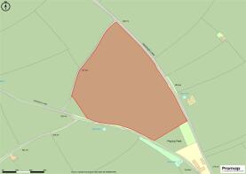
Land off Harding's Lane, Heathcote, Buxton, SK17 0AY

- PROPERTY TYPE
Land
- SIZE
384,635 sq ft
35,734 sq m
Key features
- Useful parcel of productive grassland
- Approximately 8.83 acres (3.57 hectares),
- Suitable for both mowing and grazing,
- Multiple gated roadside access points
- In the Peak District National Park
Description
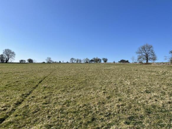
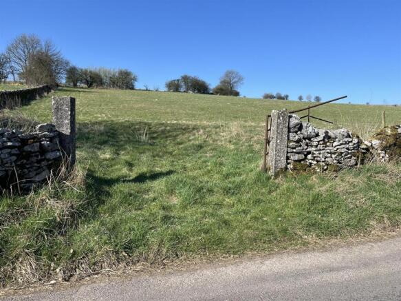
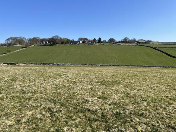
Description - The land offers a useful parcel of productive grassland, extending to approximately 8.83 acres (3.57 hectares), suitable for both mowing and grazing, and has previously been utilised for arable production. Bounded by dry stone walling and post and wire fencing, the land offers multiple gated roadside access points. The land presents an opportunity to acquire a parcel of this acreage, which will suit those with agricultural and equestrian purposes.
Location - Situated in peaceful rural position within the Peak District National Park, the land locates between a number of popular Derbyshire villages with good roadside access. The sought-after village of Hartington offers a range of basic amenities and situates just 1.3 miles to the west. Further nearby towns and villages include Biggin (1.1 miles), Warslow (4.4 miles), Monyash (4.6 miles), Bakewell (9.7 miles), and Buxton (11.7 miles). There are many nearby local walks, bridleways, trails in the surrounding area, excellent for those who enjoy the outdoors and with equestrian interests.
Directions - From the centre of Hartington village, head east along the B5054 and follow the road for approximately 0.8 miles. As the road forks, bear right onto Hardings Lane and climb up the hill, for approx. 0.5 miles continuing past the left hand turning for Heathcote, the land can be found on the right hand side, indicated by our ‘For Sale’ board.
What3words/// flask.slope.searched
Services - We are not aware of any services available at the property.
Tenure And Possession - The land is sold freehold with vacant possession.
Sporting, Mineral And Timber Rights: - We understand the sporting, and timber rights are included as far they exist. Mineral rights are excluded for the sale.
Viewing - The land may be viewed at any reasonable time when in possession of a copy of these particulars. Please park carefully.
Rights Of Way, Wayleaves And Easements: - The property is sold subject to and with the benefit of all rights of way, wayleaves and easements whether or not defined in these particulars.
Vendor's Solicitors: - Cowlishaw & Mountford, 90 High Street, Uttoxeter , Staffordshire ST14 7JD
Method Of Sale - This property is to be sold by Private Treaty
Local Authority - Derbyshire Dales District Council, Town Hall, Bank Rd, Matlock DE4 3NN
Local Planning Authority: - Peak District National Park Authority, Aldern House, Baslow Road, Bakewell, Derbyshire DE45 1AE
Agents Notes - Bagshaws LLP have made every reasonable effort to ensure these details offer an accurate and fair description of the property. The particulars are produced in good faith, for guidance only and do not constitute or form an offer or part of the contract for sale. Bagshaws LLP and their employees are not authorised to give any warranties or representations in relation to the sale and give notice that all plans, measurements, distances, areas and any other details referred to are approximate and based on information available at the time of printing.
Brochures
Brochure Land off Harding's Lane, Heathcote.pdfBrochureLand off Harding's Lane, Heathcote, Buxton, SK17 0AY

NEAREST STATIONS
Distances are straight line measurements from the centre of the postcode- Matlock Station9.3 miles
About Bagshaws, Bakewell
The Agricultural Business Centre, Agricultural Way, Bakewell, DE45 1AH

Notes
Disclaimer - Property reference 33792186. The information displayed about this property comprises a property advertisement. Rightmove.co.uk makes no warranty as to the accuracy or completeness of the advertisement or any linked or associated information, and Rightmove has no control over the content. This property advertisement does not constitute property particulars. The information is provided and maintained by Bagshaws, Bakewell. Please contact the selling agent or developer directly to obtain any information which may be available under the terms of The Energy Performance of Buildings (Certificates and Inspections) (England and Wales) Regulations 2007 or the Home Report if in relation to a residential property in Scotland.
Map data ©OpenStreetMap contributors.