Pant Lane, Dudleston, Ellesmere
- PROPERTY TYPE
Detached
- BEDROOMS
4
- BATHROOMS
1
- SIZE
Ask agent
- TENUREDescribes how you own a property. There are different types of tenure - freehold, leasehold, and commonhold.Read more about tenure in our glossary page.
Freehold

Key features
- Residential Farm with 4 Bedroom Farm House
- Extending in all to around 22.25 acres (9.11 ha)
- Range of traditional and more modern farm buildings
- Situated in an elevated position overlooking open countryside
- In need of a scheme of modernisation and improvement
- EPC Rating 'G' (14)
Description
Location
Pant Farm is situated in the parish of Dudleston being approximately 6 miles north-west of the popular market town of Ellesmere and 9 miles north-east of Oswestry. The property itself stands in open countryside with superb views over its own land and offering all the benefits of a rural location alongside proximity to local facilities and transport links. The villages of Overton, St Martins and Gobowen contain a range of shops, a supermarket, Public Houses and amenities including Primary and Secondary Schools. Ellesmere and Oswestry provide additional amenities while easy access onto the A5 and A483 provides links to the County town of Shrewsbury, the cities of Wrexham and Chester and the motorway network beyond. Gobowen has a train station providing rail links to Birmingham and Chester.
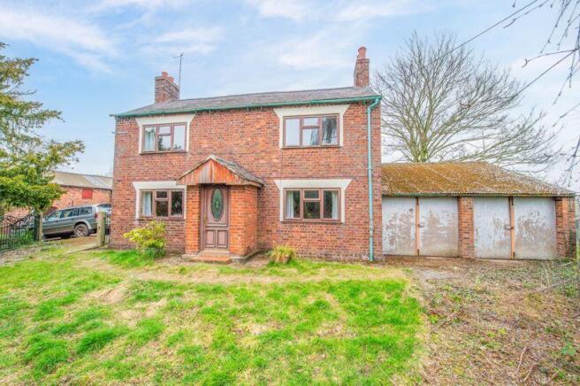
Farmhouse
The property itself is accessed off its own private driveway which splits to provide separate access to the more modern farm buildings and yards to the rear and the main courtyard which is enclosed by the substantial range of traditional brick built farm buildings and the farmhouse itself. A separate access off this yard leads to the front gardens, garage and the front access to the farmhouse:
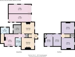
Accommodation
The farmhouse itself is constructed of brick under a slate roof and benefits from timber framed double glazed windows throughout. The main front entrance door leads into a Porch and into the:
Entrance Hall
With stairs to first floor and doors into:
Dining Room
13' 10'' x 12' 2'' (4.22m x 3.72m)
Former open fire which has been blocked off, although could be re-opened.
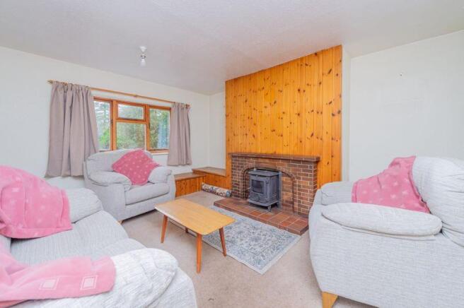
Lounge
13' 11'' x 12' 2'' (4.25m x 3.71m)
Tiled fireplace and hearth having Aga wood burning stove set on it.
Bathroom
8' 9'' x 6' 2'' (2.66m x 1.89m)
With panel bath and pedestal wash hand basin.
Pantry/Cold Room
8' 3'' x 9' 3'' (2.52m x 2.83m)
With original tiled shelves.
Kitchen
12' 0'' x 12' 1'' (3.65m x 3.68m)
Fitted kitchen with base units and matching eye level wall cupboards with worktop over and inset stainless steel sink and drainer. Solid fuel fired Rayburn which serves the domestic hot water system. Space and plumbing for a washing machine. Door to outside and walkway into:
Cloakroom
9' 0'' x 6' 1'' (2.74m x 1.85m)
With low level flush WC, pedestal wash hand basin and having a tiled floor.
Stairs from porch leading to:
First Floor Landing
With doors to:
Bedroom 1
14' 1'' x 12' 3'' (4.28m x 3.74m)
Having a fitted cupboard.
Bedroom 2
14' 1'' x 12' 3'' (4.28m x 3.74m)
Bedroom 3
12' 3'' x 8' 11'' (3.73m x 2.72m)
Leading into:
Bedroom 4
12' 1'' x 9' 1'' (3.69m x 2.76m)
With airing cupboard.
Gardens
To the front of the house is a good sized garden containing a host of mature shrubs and trees.
Double Garage
Adjoining the main house
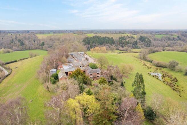
Traditional Farm Buildings (marked 1 on aerial photo)
Immediately adjacent to the rear and side of the house is an 'L' shaped range of traditional brick building farm buildings with a ground floor (measuring 16m x 4.5m & 14.5m x 3.75 approximately) comprising of former Cow Sheds and Stables on the ground floor with a hay loft above. These buildings offer a host of potential future uses subject to any necessary planning consents.
Adjoining the buildings are a Dutch Barn and a brick and block built farm building connected by a metal sheeted lean to (marked 2 on aerial photo)
Workshop (Marked 3 on aerial photo)
68' 11'' x 23' 0'' (21m x 7m)
Constructed of brick with concrete floor, having electric and power points throughout.
Surrounding this building are a number of concrete yards with provide access to a more modern range of farm buildings comprising of:
Building 1 (Marked 4 on aerial photo)
73' 10'' x 27' 11'' (22.5m x 8.5m)
Fully enclosed by timber cladding with concrete floor.
Building 2 (Marked 5 on aerial photo)
73' 10'' x 27' 1'' (22.5m x 8.25m)
Timber clad on 3 sides with open front to allow vehicular access. Concrete base.
Building 3 (Marked 6 on aerial photo)
77' 1'' x 30' 4'' (23.5m x 9.25m)
Land
The land totally surrounds the main farmstead and is all laid to permanent pasture and is split into separate fields by mature hedgerows and stock proof fencing. There is a pond to the lower area of the field immediately to the East of the farmhouse. The land borders onto a wooded area and stream. Two of the fields have gates leading onto the main driveway and there is a small building constructed of timber posts under a metal sheeted roof close to the driveway entrance.
Services
We are informed that the property is connected to mains water and electricity, with a private septic tank drainage system. A solid fuel fired Rayburn in the kitchen provides the domestic hot water supply. The property benefits from 300 Mbps fibre. The original brick built well is still situated in the main courtyard.
Council Tax
Council Tax Band 'D'
Local Authority
Shropshire Council, The Shirehall, Abbey Foregate, Shrewsbury, SY2 6ND.
Tel:
EPC Rating
EPC Rating: G (14)
Tenure
We understand that the property is Freehold subject to Vacant Possession on completion.
Directions
From the A5/A483 take the B5070 towards St Martins. Continue through the village on the B5069 before taking the 1st left at the roundabout next to Stans Superstore onto Overton Road. Continue for approximately 3 miles before taking the right turn just before the bridge on the Welsh border. Proceed along Pant Lane for approximately 1/4 mile where the property will be found on the left identified by the agents board.
What3Words Location
///dugouts.chromatic.crawling
Brochures
Property BrochureFull Details- COUNCIL TAXA payment made to your local authority in order to pay for local services like schools, libraries, and refuse collection. The amount you pay depends on the value of the property.Read more about council Tax in our glossary page.
- Band: D
- PARKINGDetails of how and where vehicles can be parked, and any associated costs.Read more about parking in our glossary page.
- Yes
- GARDENA property has access to an outdoor space, which could be private or shared.
- Yes
- ACCESSIBILITYHow a property has been adapted to meet the needs of vulnerable or disabled individuals.Read more about accessibility in our glossary page.
- Ask agent
Pant Lane, Dudleston, Ellesmere

Add an important place to see how long it'd take to get there from our property listings.
__mins driving to your place

Your mortgage
Notes
Staying secure when looking for property
Ensure you're up to date with our latest advice on how to avoid fraud or scams when looking for property online.
Visit our security centre to find out moreDisclaimer - Property reference 12333320. The information displayed about this property comprises a property advertisement. Rightmove.co.uk makes no warranty as to the accuracy or completeness of the advertisement or any linked or associated information, and Rightmove has no control over the content. This property advertisement does not constitute property particulars. The information is provided and maintained by Bowen, Oswestry. Please contact the selling agent or developer directly to obtain any information which may be available under the terms of The Energy Performance of Buildings (Certificates and Inspections) (England and Wales) Regulations 2007 or the Home Report if in relation to a residential property in Scotland.
*This is the average speed from the provider with the fastest broadband package available at this postcode. The average speed displayed is based on the download speeds of at least 50% of customers at peak time (8pm to 10pm). Fibre/cable services at the postcode are subject to availability and may differ between properties within a postcode. Speeds can be affected by a range of technical and environmental factors. The speed at the property may be lower than that listed above. You can check the estimated speed and confirm availability to a property prior to purchasing on the broadband provider's website. Providers may increase charges. The information is provided and maintained by Decision Technologies Limited. **This is indicative only and based on a 2-person household with multiple devices and simultaneous usage. Broadband performance is affected by multiple factors including number of occupants and devices, simultaneous usage, router range etc. For more information speak to your broadband provider.
Map data ©OpenStreetMap contributors.