Land Development Opportunity, Common Lane, Knottingley, WF11 8BN

- SIZE AVAILABLE
2,308,680 sq ft
214,484 sq m
- SECTOR
Land for sale
Key features
- Excellent Development Opportunities;
- Zoned for employment uses
- Excellent access to labour;
- Planning potential for alternative uses subject to consent;
- Site area approximately 53 acres (21.45 hectares);
- M62 - junction 33 (3 miles) and junction 34 (4.5 miles)
Description
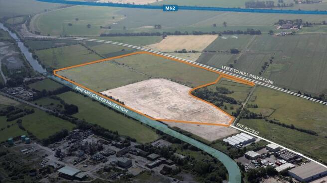
The site comprises approximately 53 acres (21.45 hectares) and is bounded by Common Lane and Blackburn Lane to the west, an operational railway line to the south, the Knottingley and Goole Canal to the north and Southmoor Lane to the east.
The site is made up of two main areas which are the former chemical works (7.5 hectares approximately) and the greenfield area to the east and south (13.96 hectares approximately). The site is fairly level with a maximum fall of approximately 1 metre across the site, the highest point on the former chemical works.
The Aire and Calder Navigation flows along the northern boundary of the wider site. To the east of the property is agricultural land and running along the southern boundary of the property and the wider site is a railway line. The land to the west of the subject property and comprising the western section of the wider site (where residential development is proposed) currently comprises agricultural/ grazing land, and beyond is a residential area.
Location
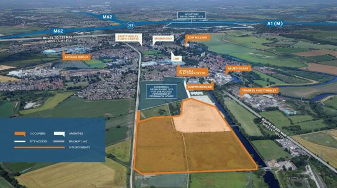
The property is located on the eastern outskirts of Knottingley town centre, to the south of the A645 Weeland Road. Access to the subject property is from Common Lane which runs through the wider site and connects with Weeland Road approximately 450 metres to the west of the subject property.
Knottingley is a town within the metropolitan borough of the city of Wakefield in the county of West Yorkshire. The town is located to the north of the M62 motorway and to the east of the A162, which comprises the former A1 trunk road. Access to the national motorway network is available at Junction 33 of the M62 (via the A162) - 6 mins 3 miles, a short distance to the south west of the town. The M62/A1M intersection is located approximately 1 mile to the north west of Junction 33.
Further access is available via J34 of the M62 via Weeland Road approximately 4.5 miles to the east 7 mins.
Viewings
Interested parties wishing to view the site are asked to provide prior notification to Sole Selling Agents Savills before viewing.
Data Room
An information pack is available on receipt of an Expression of Interest which includes the following:
• Title information
• Topographical survey
• Drainage and flood risk assessment
• Highways report
• Utility plans
• Planning Summary report
Geotechnical reports and validation.
Planning
The site was reallocated under policy reference SPA26 on 24 January 2024. Policy SPA26 states that, “The site will be developed for housing and approximately 20 hectares in the eastern area of the allocation for employment (E(g)(ii), Research and development of products or processes, E(g)(iii) industrial processes, B2 General Industrial and B8 Storage and Distribution).
Legal and Surveying Fees
Each party is to be responsible for their costs incurred in the transaction.
Bids Process
Interested parties are required to confirm their interest in the land and to provide outline details of the following which will form part of the assessment criteria.
Offers will be considered on a conditional and unconditional basis and are invited by 10 July 2025.
Please contact for further information on the bids process.
Brochures
Land Development Opportunity, Common Lane, Knottingley, WF11 8BN

NEAREST STATIONS
Distances are straight line measurements from the centre of the postcode- Knottingley Station1.2 miles
- Pontefract Monkhill Station3.0 miles
- Pontefract Baghill Station3.0 miles
Notes
Disclaimer - Property reference 80397-1. The information displayed about this property comprises a property advertisement. Rightmove.co.uk makes no warranty as to the accuracy or completeness of the advertisement or any linked or associated information, and Rightmove has no control over the content. This property advertisement does not constitute property particulars. The information is provided and maintained by Savills, Leeds Industrial. Please contact the selling agent or developer directly to obtain any information which may be available under the terms of The Energy Performance of Buildings (Certificates and Inspections) (England and Wales) Regulations 2007 or the Home Report if in relation to a residential property in Scotland.
Map data ©OpenStreetMap contributors.