Brockhall Village, Old Langho
- SIZE
Ask agent
- TENUREDescribes how you own a property. There are different types of tenure - freehold, leasehold, and commonhold.Read more about tenure in our glossary page.
Freehold
Description
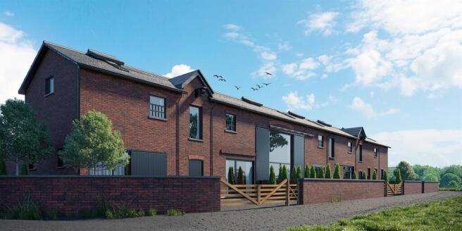
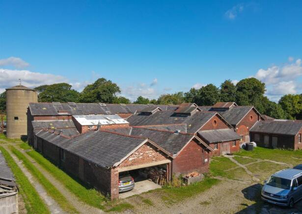
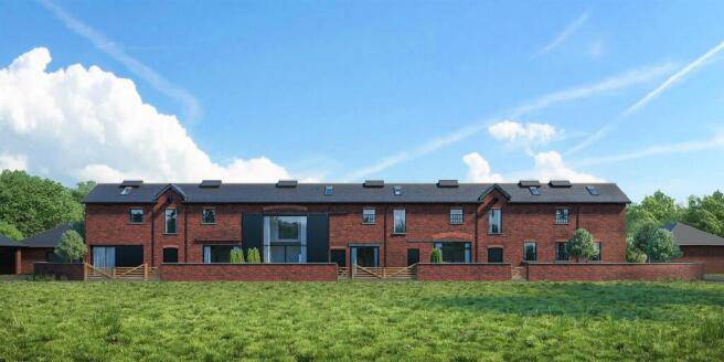
- The development site includes farm buildings with planning consent for conversion to eight, large executive residential units.
- The total gross internal area is just over 17,000 Sq Ft.
- Precise boundaries are to be agreed but there is approximately 2 acres of land included in the sale.
- Further land is available by separate negotiation.
- All plans & details for the proposed development can be found on the Ribble Valley planning portal (Application Number - 3/2021/0311).
The Farmstead Building - The Building Development
1.9 Acres (0.84ha)
Brockhall Farm was built in connection with Brockhall Hospital which was opened in 1904 and closed in 1992 when the site was redeveloped as a gated community (now Brockhall Village) and Blackburn Rovers training ground which lies on the Southern and Western boundaries of the property. The farm was bought by the current vendors family in 1974 and has been farmed as a dairy and stock farm since then. It is thought that the site has been occupied by a farm since the sixteenth century and perhaps even earlier, but there is no structural evidence of any such earlier buildings on the site now.
Planning consent to demolish and/or convert a number of the buildings into 8 residential properties along with the construction of a number of garages, parking, gardens and amenity space for each property was obtained from Ribble Valley Borough Council on 27 August 2021.
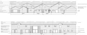
Full details of the consent are available on the Ribble Valley Borough Council planning portal - Application number 3/2021/0311. Briefly the consent will create eight new dwellings with a total Gross Internal Floor Area of 1,602m2 (17,244 sq ft) plus garages, courtyard and garden areas.
The existing features of the farm buildings have been maintained and celebrated, including internal courtyards, exposed structure and materials, double height spaces and large barn door openings.
Access is via an existing lane from Old Langho Road via the rear of Larkhill Cottages. Mains electricity is connected and drainage will be via a new sewage treatment plant. A new mains water connection will be required.
There are no public rights of way through the farmstead.
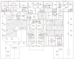
The Properties - The properties will be arranged as per the floor plans shown herein and briefly comprise -
Property One
Single storey property - 199m2 / 2,142 Sq Ft
Property Two
Duplex property - 157m2 / 1,690 Sq Ft
Property Three
Duplex property - 157m2 / 1,690 Sq Ft
Property Four
Duplex property - 189m2 / 2,034 Sq Ft
Property Five
Single storey property - 119m2 / 1,281 Sq Ft
Property Six
Duplex property - 204m2 / 2,196 Sq Ft
Property Seven
Duplex property - 271m2 / 2,917 Sq Ft
Property Eight
Duplex property - 306m2 / 3,294 Sq Ft
Total Gross Internal Area = 1,602m2 / 17,244 Sq Ft
Access from the highway is in private ownership for which there is a 50% maintenance liability.
Other Information - -
services
The farmstead is supplied with mains water and electric with drainage
to a septic tank.
tenure
We understand from the owners to be Freehold.
viewings
Strictly by appointment
Brochures
Brockhall Village, Old LanghoBrochure- COUNCIL TAXA payment made to your local authority in order to pay for local services like schools, libraries, and refuse collection. The amount you pay depends on the value of the property.Read more about council Tax in our glossary page.
- Ask agent
- PARKINGDetails of how and where vehicles can be parked, and any associated costs.Read more about parking in our glossary page.
- Yes
- GARDENA property has access to an outdoor space, which could be private or shared.
- Yes
- ACCESSIBILITYHow a property has been adapted to meet the needs of vulnerable or disabled individuals.Read more about accessibility in our glossary page.
- Ask agent
Energy performance certificate - ask agent
Brockhall Village, Old Langho

Add an important place to see how long it'd take to get there from our property listings.
__mins driving to your place
Get an instant, personalised result:
- Show sellers you’re serious
- Secure viewings faster with agents
- No impact on your credit score


Your mortgage
Notes
Staying secure when looking for property
Ensure you're up to date with our latest advice on how to avoid fraud or scams when looking for property online.
Visit our security centre to find out moreDisclaimer - Property reference 33867616. The information displayed about this property comprises a property advertisement. Rightmove.co.uk makes no warranty as to the accuracy or completeness of the advertisement or any linked or associated information, and Rightmove has no control over the content. This property advertisement does not constitute property particulars. The information is provided and maintained by Athertons, Property & Land. Please contact the selling agent or developer directly to obtain any information which may be available under the terms of The Energy Performance of Buildings (Certificates and Inspections) (England and Wales) Regulations 2007 or the Home Report if in relation to a residential property in Scotland.
*This is the average speed from the provider with the fastest broadband package available at this postcode. The average speed displayed is based on the download speeds of at least 50% of customers at peak time (8pm to 10pm). Fibre/cable services at the postcode are subject to availability and may differ between properties within a postcode. Speeds can be affected by a range of technical and environmental factors. The speed at the property may be lower than that listed above. You can check the estimated speed and confirm availability to a property prior to purchasing on the broadband provider's website. Providers may increase charges. The information is provided and maintained by Decision Technologies Limited. **This is indicative only and based on a 2-person household with multiple devices and simultaneous usage. Broadband performance is affected by multiple factors including number of occupants and devices, simultaneous usage, router range etc. For more information speak to your broadband provider.
Map data ©OpenStreetMap contributors.