Land at Lower Penn, Dirtyfoot Lane, Wolverhampton

- PROPERTY TYPE
Land
- SIZE
Ask agent
Key features
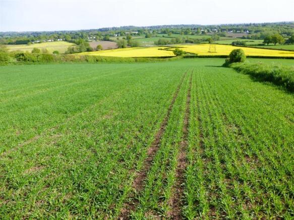
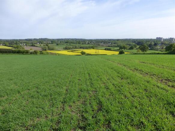
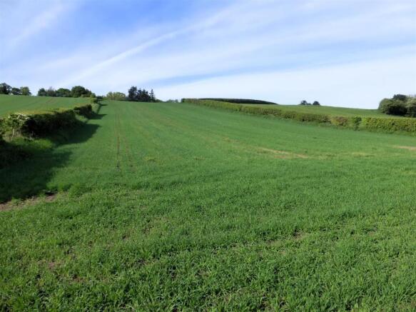
- 12.58 acres of Grade III Arable Land.
- Split into two parcels both with road frontage access.
- Good cropping and stocking capabilities
- Opportunity for equestrian use.
- Close proximity to Wolverhampton (5 miles) and Birmingham (20 miles) and surrounding villages
- For Sale by Informal Tender as a Whole or in Two Lots
- Tenders to be received by 12 Noon on Friday 27th June 2025
Description
The Land - Lot 1 - Parcel 3826 extends approximately 8.68 acres of level arable land with access taken via an existing gateway off Dirtyfoot Lane. The land is enclosed by mature hedgerows and fencing.
Lot 2 - Parcel 2497 extends approximately 3.90 acres of gently sloping arable land which is accessed directly off Dirtyfoot Lane enclosed by established hedgerows.
Cropping - SO8796 3826 - Oil Seed
SO8795 2497 - Spring Barley
Services - None.
Tenure - The property is offered freehold with vacant possession upon completion of the sale.
Public Rights Of Way - Field parcel 3826 is subject to a Public footpath extending partway up the eastern boundary.
Wayleave, Easements & Rights Of Way - The Environment Agency have an existing right of way along the existing stone track in field parcel 3826. We understand the electricity pylon is held under existing rights in favour of National Grid.
Planning Uplift - The land is sold with an overage clause in favour of the vendor for future alternative development outside agricultural and equestrian use with a 30% uplift in value of the land for alternative development on the grant of planning permission, for a period of 25 years.
Local Authority And Public Utilities - Wolverhampton City Council Civic Centre, St Peters Square, Wolverhampton WV1 1SH
National Grid Electricity Distribution, Avonbank, Feeder Road, Bristol, Avon, BS2 0TB
Severn Trent Water, Severn Trent Centre, 2 St John's Street, Coventry, CV1 2LZ
Timber, Sporting & Mineral Rights - All standing timber, mineral rights or any sporting rights, if owned are included within the sale.
Basic Payment Scheme & Stewardship Schemes - The land has been registered with the Rural Payments Agency. The delinked payments under the Basic Payment Scheme are reserved by the Vendor. In so far as we are aware the land is not subject to any Environmental Stewardship Scheme.
Nitrate Vulnerable Zone - The land is situated within a Nitrate Vulnerable Zone.
Guide Prices - Lot 1 - 8.67 acres offers in the region of £100,000
Lot 2 - 3.90 acres offers in the region of £50,000
Money Laundering - As a result of anti-laundering legislation Prospective Purchasers will need to show proof of ID (Photo ID for example passport or driving licence and Residential ID for example current utility bill).
Viewings - Prospective Purchasers can view the land during reasonable times and during daylight hours. We request that anyone wishing to view the land contacts the selling agents in advance.
Health & Safety Notice - Prospective Purchasers should take all necessary care when making an inspection including wearing suitable clothing. Viewings are taken solely at the risk of those who view and neither the Agents nor the owners of the property take responsibility for any injury however caused.
Mode Of Sale - The land is being offered for sale as a whole by Informal Tender. Prospective Purchasers should carry out their own enquiries with City of Wolverhampton Council and other Authorities before making an offer for the land. It is envisaged that no further negotiations will be entered into after the informal tender closing date. The Informal Tender Documents should be signed by the proposed Purchaser (s) stating the proposed purchase price and should include a completed Land Registry Identity Form (ID1). These are to be received by Gareth Wall at Sunderlands, Offa House, St Peters Square, Hereford HR1 2PQ by 12 Noon on Friday 27th June 2025. Envelopes should be marked “Informal Tender for the Land at Lower Penn” and substantially sealed. The Vendor reserves the right not to accept the highest, or any, offer if they so wish. The Vendor reserves the right to accept an offer prior to the Informal Tender date.
Agents Note - Any plans used in the preparation of these details may have been reduced in scale and any interested parties should check the Title Plan before proceeding to purchase.
Important Notice - These particulars are set out as a guide only. They are intended to give a fair description of the property but may not be relied upon as a statement or representation of facts. These particulars are produced in good faith but are inevitably subjective and do not form part of any Contract. No persons within Sunderlands have any authority to make or give any representation or warranty whatsoever in relation to the property.
Directions - From Wolverhampton City Centre head south on A449 (Penn Road) for 3 miles, take the second exit at the roundabout onto Warstones Road and after a short distance turn left onto Spring Hill Lane follow this lane for appox. 1 mile to Lower Penn and turn right onto Dirty Foot Lane, continue this lane and the land can be found after a short distance on the left and right.
The Lots are marked by For Sale boards.
What3words // guest.water.bands
Brochures
Brochure _Lower Penn.pdfBrochureLand at Lower Penn, Dirtyfoot Lane, Wolverhampton

NEAREST STATIONS
Distances are straight line measurements from the centre of the postcode- Wolverhampton St George's Tram Stop3.0 miles
- The Royal Tram Stop3.2 miles
- Wolverhampton Station3.3 miles


Notes
Disclaimer - Property reference 33876818. The information displayed about this property comprises a property advertisement. Rightmove.co.uk makes no warranty as to the accuracy or completeness of the advertisement or any linked or associated information, and Rightmove has no control over the content. This property advertisement does not constitute property particulars. The information is provided and maintained by Sunderlands, Hereford. Please contact the selling agent or developer directly to obtain any information which may be available under the terms of The Energy Performance of Buildings (Certificates and Inspections) (England and Wales) Regulations 2007 or the Home Report if in relation to a residential property in Scotland.
Map data ©OpenStreetMap contributors.