Church Lane, Keyingham, Hull
- PROPERTY TYPE
Land
- SIZE
72,745 sq ft
6,758 sq m
Key features
- For Sale by Informal Tender
- c.1.67 Acre (0.67 Hectare) Grass Paddock
- Shelter, Store & Small Hay Barn
- Mains Water Supply
- Edge of Village Location
- Possible Long Term Development Potential
- Freehold with Vacant Possession
Description
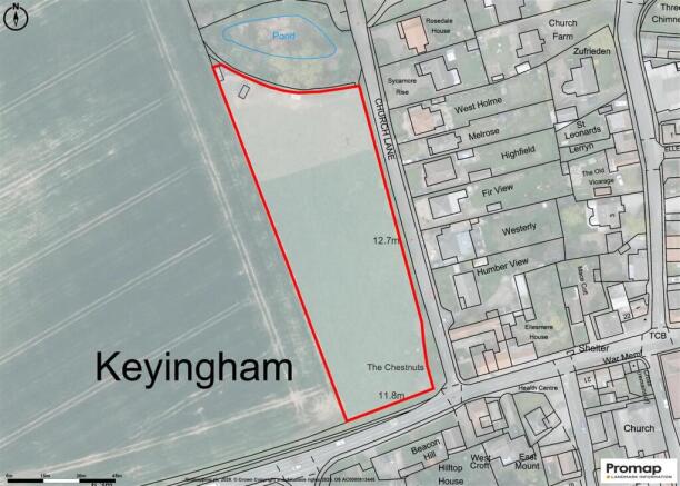
Location & What3words - The land is located in the Holderness Village of Keyingham which straddles the A1033 Hull to Withernsea Road, lying approximately 6 miles east of Hull City's boundary. The Paddock is situated on the western fringe of the village and is approached from Church Lane. Field gate, what3words ///wheels.shipwreck.caskets
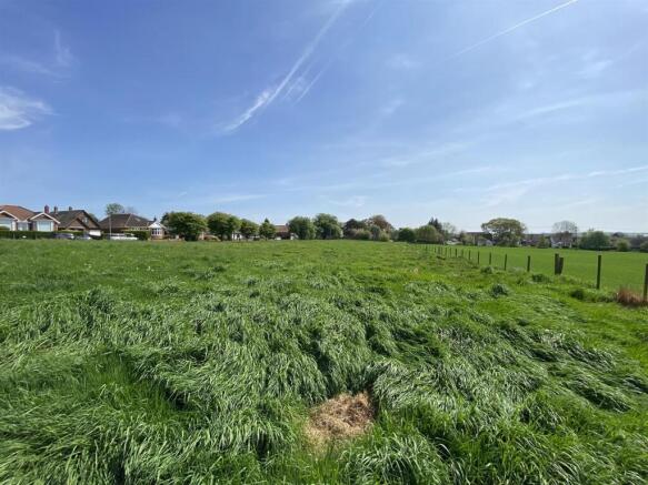
Description - The grass paddock extends to approximately 1.67 Acres (0.67 Hectares), is of a regular shape with a south facing aspect, fenced and with a mains water supply
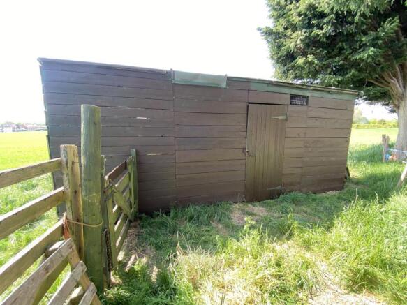
Buildings - These include:
Stores - 6.2 x 4.2 (20'4" x 13'9") - Timber construction with a felt roof and timber raised floor
Hay Barn - 4.1 x 2.5 (13'5" x 8'2") - Timber construction, part clad and roofed in metal profile sheeting with earth floor
Shelter/Former Railway Carraige - 5.3 x 2.4 (17'4" x 7'10") - A former railway carriage converted to a field shelter with concrete floor
Services - A metered mains water supply is connected to a water trough
Method Of Sale - The land is to be offered by Informal Tender, based upon offers over £45,000. Interested parties are requested to register their contact details with the sole agents so they can be kept informed of the marketing progress and future Tender date for submission of best offers. The vendor reserves the right to conclude the sale by any other means at their discretion
Wayleaves, Easements & Rights Of Way - The land is sold subject to and with the benefit of all wayleaves, easements or quasi easements and rights of way, light, support, drainage, services supplies whether mentioned in these particulars or not and without any obligations to define the same respectively. There is an electric wayleave crossing the southern end of the paddock with one single and two double poles. No rights of way cross the land to the vendors knowledge.
Development Uplift/Overage - A "Development Uplift" (overage) is to be imposed on the basis that should and if the land use be changed away from agriculture, horticulture, equine or a dog exercise use either through any planning consent or permitted development rights (under the General Development Consent Order) then a "Development Uplift’"(overage) would be payable to the vendor or their successors in title. This would be based upon 20% of the increase in the Market Value of the property immediately before the planning consent/permitted development, was granted (excluding any hope value) and the Market Value of the property immediately after planning/permitted development consent is granted but taking into account the terms of any such consent. The overage/development uplift is imposed for a period of 15 years.
Deductions - The purchaser shall make no claim for deductions or dilapidations what so ever.
Tenure & Possession - The property is available Freehold with Vacant Possession on completion.
Health & Safety - Please take care when viewing the property being as vigilant as possible when making an inspection for your own personal safety.
Plans & Measurements - Any plans forming part of these particulars are included for identification purposes and do not form part of the contract for sale. Areas or measurements where stated are given as a guide only and should be checked by you or your own agent(s).
Mineral Rights - The mining and mineral rights (so far as these are owned) are included in the sale.
Planning - Current planning policy is governed by the new East Riding Local Plan, Strategy Document and Policies map which were adopted April 2025. Under the prevailing Local Plan, the site lies outside the development limit of the village and as a consequence it lies within ‘open countryside’. The land falls with Policy EC6 as a 'Minerals Safeguarding Area'. Further enquires should be directed to the East Riding of Yorkshire Council's Planning department or you should seek your own independent advice from a Chartered Town Planner as to possible future use.
Local & Statutory Authorities - The East Riding of Yorkshire Council, County Hall, Beverley, HU17 9BA Tel: Web:
Yorkshire Water Services Tel: Web:
Northern Powergrid Tel: Web:
Viewings - By appointment with Leonards , whereupon the access gate on Church Lane will be unlocked.
Brochures
Church Lane, Keyingham, HullBrochureChurch Lane, Keyingham, Hull

NEAREST STATIONS
Distances are straight line measurements from the centre of the postcode- Stallingborough Station9.0 miles
Notes
Disclaimer - Property reference 33879379. The information displayed about this property comprises a property advertisement. Rightmove.co.uk makes no warranty as to the accuracy or completeness of the advertisement or any linked or associated information, and Rightmove has no control over the content. This property advertisement does not constitute property particulars. The information is provided and maintained by Leonards, Hull. Please contact the selling agent or developer directly to obtain any information which may be available under the terms of The Energy Performance of Buildings (Certificates and Inspections) (England and Wales) Regulations 2007 or the Home Report if in relation to a residential property in Scotland.
Map data ©OpenStreetMap contributors.