Wern Road, Llangollen
- PROPERTY TYPE
Land
- SIZE
Ask agent
Key features
- Informal Tender - Closing 12 Midday 16/06/25
- Approximately Half Acre Portion of Land
- Situated Close to the Shropshire Union Canal
- Included within the Current Settlement Boundary
Description
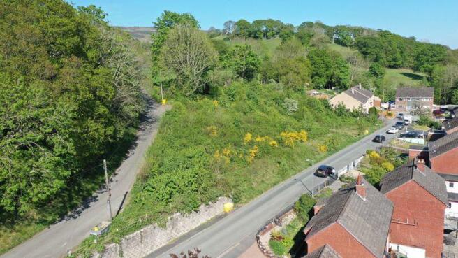
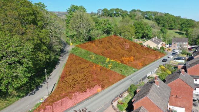
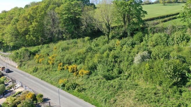
The Site
The title boundary to the portion for sale is held in two sections with a 'strip' in between that is held by SP Manweb. Beneath the SP Manweb portion there is understood to be electricity apparatus. An SP Manweb Plan is available from the Agent's Llangollen Offices - see paragraph 'Documentation' below.
The larger portion of the two sections has been measured using the ProMap Ordnance Survey Software to extend to approximately half an acre. See plans attached.
Conditions of Tender / Overage
The property is located inside the Llangollen Town Settlement Boundary as delineated by the Denbighshire County Council Development Plan. The site does not presently have planning permission and is being sold with the provision of 'Overage' to the benefit of the current vendors. The Overage will be a claw-back clause of 50% of the development value of the site. The Overage will be triggered by the issue of a planning permission by Denbighshire County Council for residential development.
Documentation
Dialogue was entered into with Denbighshire County Council during 2021 under a Pre-Application remit. Response received from the Authority affirms that in principle a planning permission for residential development could be supported on the site.
Additional documentation available for scrutiny from the Agent's Llangollen Offices includes...
Denbighshire Pre Application Advice.
Ecological Impact Assessment.
Tree Survey, Schedule and Report.
Phase 1 Habitat Survey.
Topographical Assessment (Site cross-sections).
SP Manweb Apparatus Plan.
Llangollen Tree Preservation Order Schedule.
Services
All mains services are understood to be available for connection to the site subject to statutory regulations. No formal reporting in this regard is available and prospective purchasers are advised to seek their own assurances.
Ecological
It has been revealed in the past that there has been badger activity upon the site. During 2021 a single active badger hole was located on the land, which was located to the upper north-east corner of the site. There were two other badger holes identified at that time, which were overgrown and were thought to be inactive. Underground connections could of course have been possible.
Method Of Sale
For sale by INFORMAL TENDER. Sealed offers are invited to the Agent's Llangollen Offices for the Freehold Interest of the property by no later than 12.00 pm midday on Monday 16th June 2025.
Envelopes should be marked 'Land at Wern Road' to avoid accidental opening.
Bids received shall be deemed to be individual purchasers 'final and best'. No negotiation will be entered into after the time and date specified.
Directions
From the Agent's Llangollen Offices proceed down Castle Street over the Dee Bridge and at the junction with Abbey Road turn right. Turn first left up Wharf Hill and pass over the Canal Bridge. Turn right. Continue and take the next fork right onto Wern Road, when the property will be observed on the left-hand side.
Brochures
Property BrochureFull DetailsWern Road, Llangollen

NEAREST STATIONS
Distances are straight line measurements from the centre of the postcode- Chirk Station4.9 miles

Notes
Disclaimer - Property reference 10915177. The information displayed about this property comprises a property advertisement. Rightmove.co.uk makes no warranty as to the accuracy or completeness of the advertisement or any linked or associated information, and Rightmove has no control over the content. This property advertisement does not constitute property particulars. The information is provided and maintained by Bowen, Llangollen. Please contact the selling agent or developer directly to obtain any information which may be available under the terms of The Energy Performance of Buildings (Certificates and Inspections) (England and Wales) Regulations 2007 or the Home Report if in relation to a residential property in Scotland.
Map data ©OpenStreetMap contributors.