
Lower Monubent Farm, Bolton By Bowland, Clitheroe, Lancashire
- PROPERTY TYPE
Land
- BEDROOMS
2
- BATHROOMS
1
- SIZE
20,421 sq ft
1,897 sq m

Key features
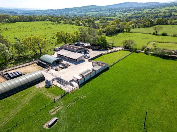
- Smallholding / Equestrian / Kennels / Industrial Unit extending to 30.94 acres (12.52 hectares) OTA
- Two bed residential accommodation subject to Agricultural Occupancy Condition.
- Substantial yard & range of quality buildings including two Workshop spaces, Livestock Buildings, Poly-Tunnels, range of Stables, Static Caravan, Kennels and Menage area.
- Agricultural grassland within ringfence.
- Private and attractive location within the Forest of Bowland Protected Landscape.
- Property with huge Equestrian, Agricultural, Lifestyle Farming and Amenity potential.
Description
The property is located in a much sought after rural location, being to the edge of the Forest of Bowland National Landscape. The rural position offers open views and peaceful surroundings, being within close proximity to the villages of Gisburn and Bolton by Bowland, and the market town of Clitheroe, being a popular residential location and within the catchment area for the desirable Ribble Valley schools.
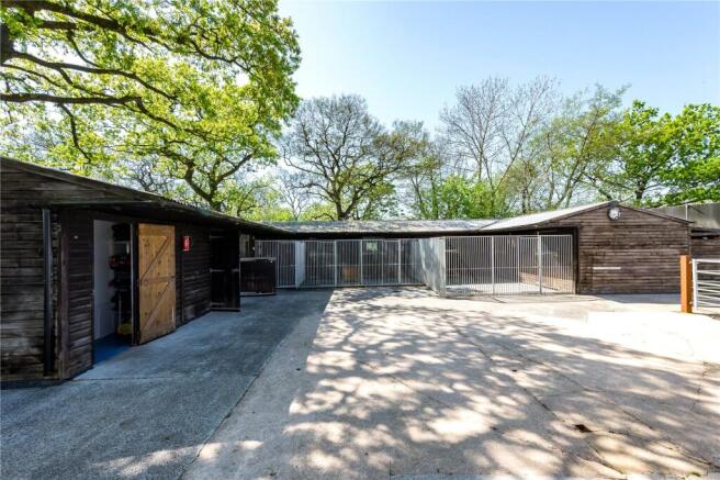
The property offers fantastic potential for a wide range of uses and development, subject to gaining the necessary planning consents. The buildings are currently being utilised as workshops and livestock housing, with the yard providing for a further range of seven timber stables. The property also includes DEFRA specification kennels and breeding facilities that currently holds a 5 star dog breeding licence with Ribble Valley Borough Council. The yard and buildings also offer huge scope for alternative amenity and equestrian use, including additional equestrian stabling, further workshop space and storage. Given the property location and position within the Forest of Bowland National Landscape, the land and property would also favour potential future leisure or environmental pursuits, subject to gaining the necessary planning consents involved.
The property is accessed via a tarmac drive leading off Hellifield Road and is a true smallholding property, being of interest to those who require peaceful surroundings, additional space and have agricultural, equestrian or diversification interests.
The current residential accommodation comprises a two bedroom property located within part of a steel portal frame agricultural building, with the property being designed and retrofit within the southern bay of the workshop. The property benefits from newly installed B4RN fibre-optic broadband, providing speeds of 700mbps.
Internally the dwelling includes a kitchen/dining/living room, large office, and shower room to the ground floor. To the first floor are two bedrooms and a further storage room. The property is subject to an Agricultural Occupancy Condition.
The site also provides great scope for the construction of a new and more standard build construction residential property, subject to gaining the necessary planning consents from the local planning authority.
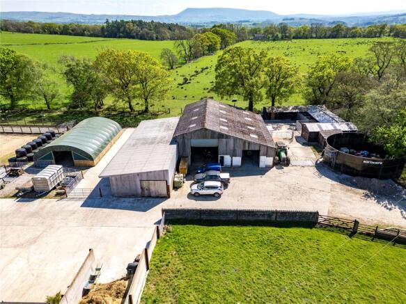
The farm buildings are centred around a substantial concrete yard area and provide for two steel portal frame workshop buildings (being internally connected via roller shutter door), constructed of concrete block under a sheet roof with sheet cladding to eaves and concrete flooring. The workshops include electric roller shutter doors and offer great scope for workshop, fabricating and engineering purposes. A further five bay steel portal frame open fronted livestock building is positioned to the side, with the building formerly being utilised as brood mare pens and now used for livestock housing. In the yard there is also a muck midden constructed with concrete panel walls.
To the rear of the main farm buildings is an ‘L shaped’ timber stable block providing for seven stables and tack room.
To the rear yard is a further 2 bedroom static caravan with front timber decking seating area. It is understood the caravan does not have formal planning consent, however has been in situ and occupied for residential purposes for over 10 years.
Within the farmyard are two Poly Tunnels measuring 100ft x 30ft and 48ft x 30ft, a range of six kennels with insulated cabins and front and rear pen space and a timber office cabin / summer house.
To the side of the yard is an equestrian menage which is currently being utilised as a dog run and bale storage area. The menage could easily be repurposed back for equestrian purposes if required. The Yard also includes a former slurry tower which is now disused and utilised for storage purposes.
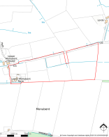
The farm is sat in approximately 30.94 acres (12.52 hectares) or thereabouts. The land comprise of predominantly meadow land and is classified as Grade 4 on DEFRA’s Agricultural Land Classification Maps for England and Wales and is made up of a number of different field enclosures positioned within a ring fence to the east of the farmyard. All the field parcels benefit from mains water and troughs. The land benefits from access off the main farm drive and through the yard.
Brochures
ParticularsEnergy Performance Certificates
EPC Rating GraphLower Monubent Farm, Bolton By Bowland, Clitheroe, Lancashire

NEAREST STATIONS
Distances are straight line measurements from the centre of the postcode- Long Preston Station4.1 miles
- Hellifield Station4.5 miles


Notes
Disclaimer - Property reference GAR240317. The information displayed about this property comprises a property advertisement. Rightmove.co.uk makes no warranty as to the accuracy or completeness of the advertisement or any linked or associated information, and Rightmove has no control over the content. This property advertisement does not constitute property particulars. The information is provided and maintained by Armitstead Barnett, Clitheroe. Please contact the selling agent or developer directly to obtain any information which may be available under the terms of The Energy Performance of Buildings (Certificates and Inspections) (England and Wales) Regulations 2007 or the Home Report if in relation to a residential property in Scotland.
Map data ©OpenStreetMap contributors.