
Romsley, Halesowen, Worcestershire

- PROPERTY TYPE
Land
- SIZE
585,446 sq ft
54,390 sq m
Key features
- Pastureland
- 13.44 acres (5.44 hectares)
- Close to the village of Romsley
- Access from public highway
- Equestrian use approved
- Excellent local hacking
Description
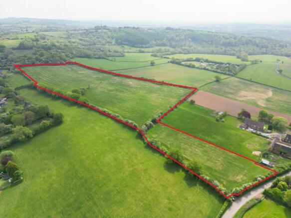
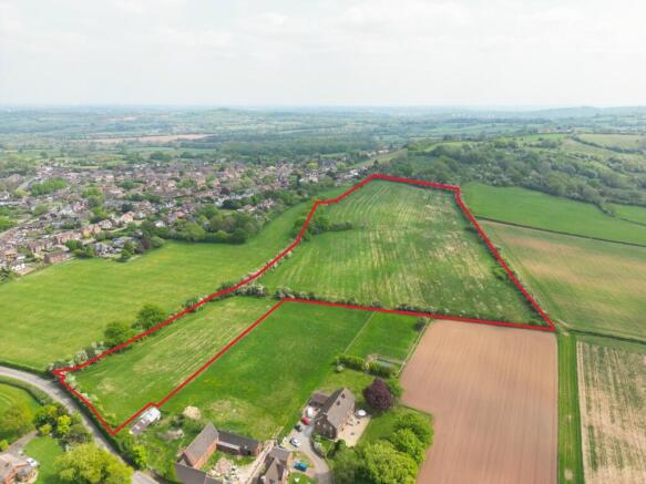
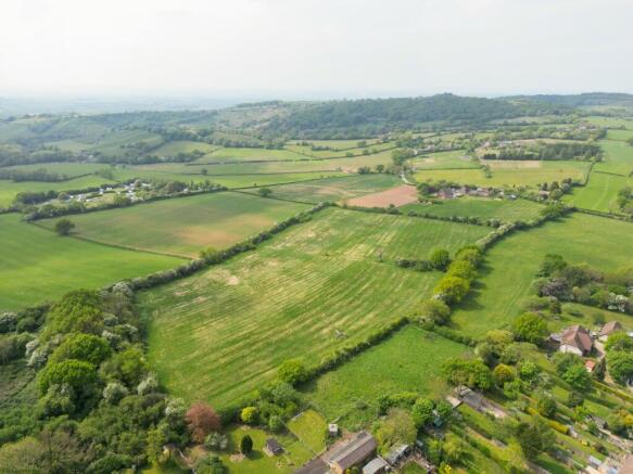
A rare opportunity to acquire a well-positioned block of equestrian pastureland, in an attractive rural setting near the sought-after village of Romsley, Worcestershire.
For sale by Private Treaty.
Description
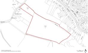
Extending to approximately 13.44 acres (5.44 hectares), the land is accessed via a five-bar gate directly from Fieldhouse Lane. It comprises well-established pasture in a useful, ring-fenced block, benefiting from equestrian as consented under planning reference B/12088/1984. The land is enclosed by mature hedgerows and fencing, and occupies an elevated position with far-reaching southerly views towards the Malvern Hills.
Situation
The land can be accessed off Fieldhouse Lane close to Halesowen, Romsley and Hagley. The area is well connected, with easy access to the motorway network with Junctions 3 and 4 of the M5 motorway nearby together with rail services to Birmingham with onward connections. Country lanes together with the nearby National Trust Clent Hills provide for excellent hacking.
Land Quality and Soil Type
The land is classified as Grade 3 according to the Natural England Regional Agricultural Land Classification Maps. The soil is described as slightly acid loamy and clayey soils with impeded drainage.
Services
The purchaser is responsible for establishing the cost for the connection of the appropriate services/utilities to the property.
Tenure and Possession
The land is freehold and vacant possession will be available on completion. The Property is registered with the Land Registry under part of title number WR68110.
Sporting, Mineral and Timber Rights
The sporting, mineral and timber rights will be transferred with the freehold title where owned.
Designations
The Property lies within a Surface Water Nitrate Vulnerable Zone (NVZ) Area and is subject to the usual restrictions. The property is within the Birmingham Greenbelt.
Public rights of way, wayleaves and easements
The Property is sold subject to and with the benefit of all easements, quasi easements, wayleaves and rights of way both declared and undeclared. We are aware of a Public Right of Way that follows the Northern boundary of the property.
Local Authority
Bromsgrove District Council
Plans and boundaries
The plans within these particulars are based on Ordnance Survey data and provided for reference only. They are believed to be correct but accuracy is not guaranteed. The purchaser shall be deemed to have full knowledge of all boundaries and the extent of ownership. Neither the vendor nor the vendor’s agents will be responsible for defining the boundaries or the ownership thereof.
Restrictive Covenants
The land will be sold subject to a restrictive covenant preventing development (as defined in Section 55 of the Town and Country Planning Act 1990). The restriction will will not apply to non-intensive agricultural or equestrian uses.
Viewings
Strictly by appointment through Fisher German LLP.
On foot at any reasonable time during daylight hours, with a copy of these particulars in hand.
Directions
Postcode –B62 0NH
What3Words - ///coats.sands.local
Brochures
ParticularsRomsley, Halesowen, Worcestershire

NEAREST STATIONS
Distances are straight line measurements from the centre of the postcode- Hagley Station3.4 miles
- Stourbridge Junction Station3.6 miles
- Lye Station3.7 miles


Notes
Disclaimer - Property reference WOR250147. The information displayed about this property comprises a property advertisement. Rightmove.co.uk makes no warranty as to the accuracy or completeness of the advertisement or any linked or associated information, and Rightmove has no control over the content. This property advertisement does not constitute property particulars. The information is provided and maintained by Fisher German, Worcester. Please contact the selling agent or developer directly to obtain any information which may be available under the terms of The Energy Performance of Buildings (Certificates and Inspections) (England and Wales) Regulations 2007 or the Home Report if in relation to a residential property in Scotland.
Map data ©OpenStreetMap contributors.