
South Zeal, Okehampton

- PROPERTY TYPE
Land
- SIZE
639,896 sq ft
59,448 sq m
Key features
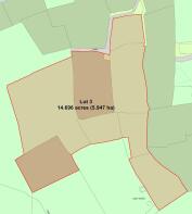
- About 14.69 acres of land
- Direct access to common land
- pasture and marginal grazing
- Spring water
- Freehold
Description
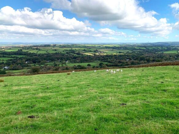
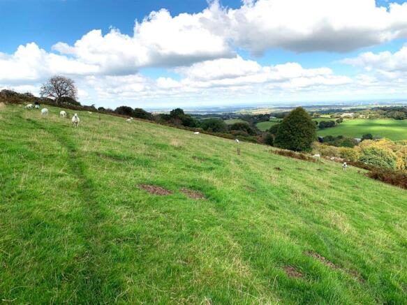
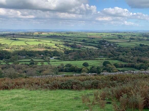
Situation - The land is located to the south of South Zeal, about 3.2 miles south of the A30 at the Coombe Head junction for Okehampton.
The land is situated within Dartmoor National Park and lies east of Cosdon Hill and South Tawton Common which can be reached by numerous bridleways and paths.
About 5 miles north is the market town of Okehampton which supplies the surrounding area with all the services and amenities one might expect to find in a local market town including a main shopping street, supermarkets, schools, churches, train station and a community hospital.
Description - The land comprises a number of east facing grazing enclosures which in total extend to about 14.69 acres. Paddocks are currently grazed together but could be divided with improvements to existing stock fencing and stone walls.
The land abuts common land to the west, allowing easy riding out with horses or for additional livestock grazing.
Additional Land Available - Lot 1 - Land at Little Bracken
About 6.17 acres of gently sloping pasture with grazing rights and quick access to common land by bridleway
Lot 2 - Coming soon
About 7.77 acres of level pasture with grazing rights and quick access to common land by bridleway
Services - No services connected.
Access - Access to the public highway by an unmetalled bridleway
Tenure And Possession - Freehold with vacant possession on completion.
Environmental Schemes - There are no active environmental schemes on the land
Designations - The land is located within Dartmoor National Park
Local Authority - West Devon Borough Council (
Dartmoor National Park (
Sporting And Mineral Rights - The sporting and mineral rights insofar as they are owned are included with the freehold.
Grazing Rights - The land has common rights to graze 13 sheep + 5 cattle or 5 ponies (8 livestock units) over South Tawton Commons CL176 & a further 26 sheep + 10 cattle + 5 ponies (20 livestock units) over both South Tawton Common CL176 & the Forest of Dartmoor CL164.
Wayleaves & Rights Of Way - The property is sold subject to and with the benefit of any wayleave agreement and any public or private rights of way that may affect it.
The land is reached by a public bridleway.
Plans & Boundary Fences - A plan which is not to scale, is included with these sale particulars for identification purposes only.
The vendor shall not be called upon to define the ownership of boundary fences.
Viewing - By appointment only. Please contact Stags Farm Agency on .
Warning - Farms and land can be dangerous places. Please take care when viewing the property, particularly in the vicinity of livestock.
Directions - From the A30 at Coombe Head, continue through Sticklepath and towards South Zeal. At Owlsfoot Garage, take the right turn at Dry Bridge, sign posted Throwleigh 2. Continue along the road for about 0.5 of a mile before taking the 2nd right turn onto the lane. Continue on the lane for about 150 metres before arriving at the land on the left.
What3words - ///artist.tangling.coconuts
Disclaimer - These particulars are a guide only and are not to be relied upon for any purpose.
Brochures
South Zeal, OkehamptonSouth Zeal, Okehampton

NEAREST STATIONS
Distances are straight line measurements from the centre of the postcode- Okehampton Station4.0 miles


Notes
Disclaimer - Property reference 33897481. The information displayed about this property comprises a property advertisement. Rightmove.co.uk makes no warranty as to the accuracy or completeness of the advertisement or any linked or associated information, and Rightmove has no control over the content. This property advertisement does not constitute property particulars. The information is provided and maintained by Stags, Exeter. Please contact the selling agent or developer directly to obtain any information which may be available under the terms of The Energy Performance of Buildings (Certificates and Inspections) (England and Wales) Regulations 2007 or the Home Report if in relation to a residential property in Scotland.
Map data ©OpenStreetMap contributors.