
Abridge Road, Abridge, Romford, Essex, RM4

- PROPERTY TYPE
Detached
- SIZE
Ask agent
- TENUREDescribes how you own a property. There are different types of tenure - freehold, leasehold, and commonhold.Read more about tenure in our glossary page.
Freehold
Key features
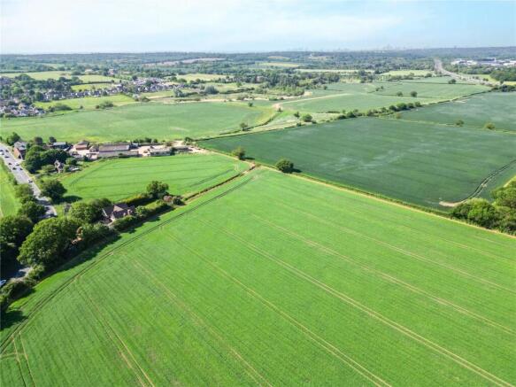
- 120.32 acres of arable and pasture land
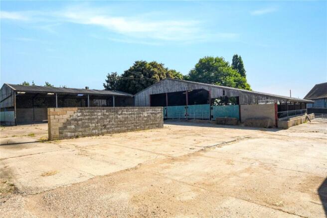
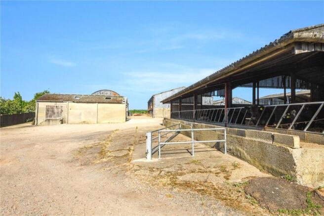
- Group of modern and traditional buildings extending to 2,083m2
- River frontage
- Permitted development for 3 residences
- Biodiversity Net Gain opportunities
Description
Description
Piggotts Farm is a compact farming unit, with the benefit of permitted development rights on 3 farm buildings in the yard, for conversion to 3 residential units, together with a number of other useful farm buildings behind. The farm lies in an accessible location just outside the popular village of Abridge, well positioned for both the M25 and M11 motorways. It is a small arable unit, with river frontage with Biodiversity Net Gain (BNG) and stewardship opportunities and a yard with extensive farm buildings totalling 2,083.09 m2.
Acreage: 120.32 Acres
Directions
The farm lies some 0.4 miles north of the village of Abridge, and some 2.5 miles from Junction 5 of M11. The buildings lie immediately adjacent to the road between Abridge and Theydon Bois with the arable land being accessed via a farm track and lying adjacent to the River Roding. A separate pasture field lies on the other side of the Abridge Road.
Currently farmed under a Farm Business Tenancy by a local farmer, it provides good opportunities for development, commercial use (subject to planning) and other forms of diversification. The land could be entered into a number of different environmental schemes or farmed as it is currently.
Additional Info
LAND AND FARM BUILDINGS
The Property is offered as a whole or in 3 lots.
Lot 1 – 0.196 hectares (0.49 acres), farm buildings with permitted development.
Coloured blue on the enclosed plan.
A compact site with permitted development rights for three dwellings.
This lot includes a yard, buildings 1, 2 and 3 plus a small area of trees forming part of planning permission EPF/1787/23 granted under Class Q on the 4/8/2023.
1. Machinery Shed (18.35 meters x 9 meters) steel portal frame, block walls with Yorkshire boarding and corrugated fibre cement sheets on a concrete floor.
2&3. Machinery Shed & Cattle Barn (18.2 meters x 23.5 meters) steel portal frame, block walls and Yorkshire boarding with corrugated fibre cement sheeting on a concrete floor.
The agricultural buildings currently present are to be part removed, part utilized in accordance with this permission. The access will be shared from the public highway with a new access being created to provide a route to the new dwellings. Shown AB on the plan with the gate to be set back to avoid congestion.
Lot 2 – 47.156 hectares (116.52 acres), farm buildings, arable and pastureland coloured pink on the plan.
A group of more modern and traditional farm buildings currently used for machinery and product storage around a concrete yard with access to the farmland to the rear and sides.
4. Cattle Yard (18.3 meters x 7.5 meters) steel portal frame, part concrete block, part Yorkshire boarding with corrugated fibre cement roof and concrete floor.
5. Open Fronted Machinery Shed (18.1 meters x 12 meters) steel portal frame building, part block walling, part Yorkshire boarding, open fronted with a concrete floor.
6. Fertiliser Store (35 meters x 13 meters) steel portal frame, part block walls, part Yorkshire boarding, corrugated fibre cement roof and concrete floor, joined to No 4.
7. Straw Store (27.2 meters x 14.8 meters) steel portal frame, sleeper walls, corrugated fibre cement roof, concrete floor.
8. Dutch Barn with Lean to (27.2 meters x 7.40 meters) corrugated iron roof, sleeper wall to one end, concrete floor.
9. Old Milking Parlour (13.5 meters x 5.7 meters) Concrete block walls, corrugated fibre cement roof.
Mains water and electricity are provided to some buildings and segregation from the site to be developed at the front will be necessary at the buyer's cost. The buyer of Lot 1 will pay for the division and separate meter.
The land is accessed from behind the farm buildings via a farm track. It is classified by DEFRA as GRADE 3 with soil type being of the Hadbury 1 and Windsor soil series.
The land is divided into 6 arable fields with an area of permanent pasture in OS 1111. The land has historically been used to grow a rotation of winter and spring cereal crops and it drains down to the River Roding at the bottom of the farm. Some of the land suffers from seasonal flooding.
There is access from the public highway through the yard to the buildings that are situated away from the road.
There is a right of way for the benefit of the land to the rear through the yard (currently farmed together with Piggotts Farm by the same farm contractor).
Lot 3 1.339 hectares (3.31 acres) Grassland
Coloured green on the plan
A small field of grassland lying opposite the farm buildings on the far east side of Abridge Road. It is classified from DEFRA as Grade 3 with soil type Windsor series. A separate metered water supply is located in the field adjacent to Epping Lane.
Brochures
Web Details- COUNCIL TAXA payment made to your local authority in order to pay for local services like schools, libraries, and refuse collection. The amount you pay depends on the value of the property.Read more about council Tax in our glossary page.
- Band: TBC
- PARKINGDetails of how and where vehicles can be parked, and any associated costs.Read more about parking in our glossary page.
- Ask agent
- GARDENA property has access to an outdoor space, which could be private or shared.
- Yes
- ACCESSIBILITYHow a property has been adapted to meet the needs of vulnerable or disabled individuals.Read more about accessibility in our glossary page.
- Ask agent
Energy performance certificate - ask agent
Abridge Road, Abridge, Romford, Essex, RM4

Add an important place to see how long it'd take to get there from our property listings.
__mins driving to your place
Get an instant, personalised result:
- Show sellers you’re serious
- Secure viewings faster with agents
- No impact on your credit score

Your mortgage
Notes
Staying secure when looking for property
Ensure you're up to date with our latest advice on how to avoid fraud or scams when looking for property online.
Visit our security centre to find out moreDisclaimer - Property reference CHR250002. The information displayed about this property comprises a property advertisement. Rightmove.co.uk makes no warranty as to the accuracy or completeness of the advertisement or any linked or associated information, and Rightmove has no control over the content. This property advertisement does not constitute property particulars. The information is provided and maintained by Savills Rural Sales, Chelmsford. Please contact the selling agent or developer directly to obtain any information which may be available under the terms of The Energy Performance of Buildings (Certificates and Inspections) (England and Wales) Regulations 2007 or the Home Report if in relation to a residential property in Scotland.
*This is the average speed from the provider with the fastest broadband package available at this postcode. The average speed displayed is based on the download speeds of at least 50% of customers at peak time (8pm to 10pm). Fibre/cable services at the postcode are subject to availability and may differ between properties within a postcode. Speeds can be affected by a range of technical and environmental factors. The speed at the property may be lower than that listed above. You can check the estimated speed and confirm availability to a property prior to purchasing on the broadband provider's website. Providers may increase charges. The information is provided and maintained by Decision Technologies Limited. **This is indicative only and based on a 2-person household with multiple devices and simultaneous usage. Broadband performance is affected by multiple factors including number of occupants and devices, simultaneous usage, router range etc. For more information speak to your broadband provider.
Map data ©OpenStreetMap contributors.