Chediston, Halesworth

- PROPERTY TYPE
Farm
- SIZE
Ask agent
Description
with some grassland.
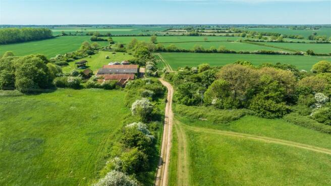
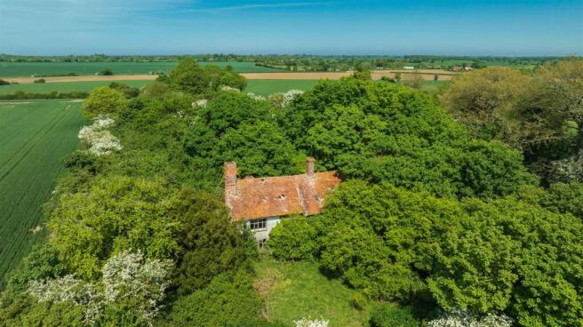
The farmhouse is approached via approximately 260 metre hard private drive leading off to Chediston Road shared with the farm and farmyard. The house which is Grade II Listed dates back to around the 17th century is dilapidated and has a footprint of about 190 square metres. The overgrown and wooded gardens which extend to about 3.42 acres (1.83 ha) or thereabouts, contain a dilapidated outbuilding and are unusual in that they contain a series of linked ponds culminating in a very large pond at the Northern end of the garden.
1. Notes: The farm was originally known as Prairie Farm.
2. The footprint for the house was measured using Land App and
not measured on site.
3. The house is not considered safe to enter.
Location And Situation - Priory Farm is located approximately 1 mile to the north of Chapel Farm off Chediston Road.
Postcode: IP19 0BD
what3words: ///garlic.floating.profiled
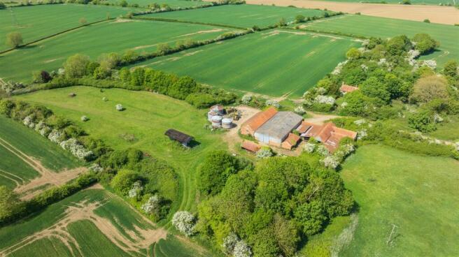
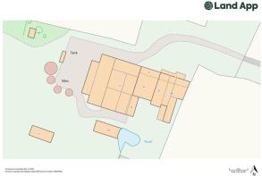
Farm Buildings - The farmyard and farm buildings are located opposite the farmhouse and comprise a range of traditional and modern farm buildings as detailed below reference to the inset plan.
1. Timber, brick and pantile roof building, 6.25m x 12.56m, with part flagstone and part concrete floor, part 6.50m x 5.60m, part 6.45m x 7.40m, with loft over. Lean to on side, 18.00m x 2.90m, subdivided into 3 sections. We understand that this was built between 1820 and 1830.
2. Steel frame machinery store/temporary grain store. Concrete block walling with part Perspex sheeted walling, 28m x 15m, with double sliding doors at either end, eaves height 6.48m and ridge height 4.05m, stable door to side.
3. 3 bay brick and pantile roof storage shed with doors to front that open to building 4 to rear, 11.26m x 5.19m.
4. Timber and galvanised open frontage store shed, part concrete block flooring, 3 bay under galvanised iron roof, overall 11.00m x 16.05m.
5. Former cow shed, brick and pantile roof building with doors at either end, 16.67m x 5.27m, plus lean to to front of 8.69m x 1.85m and 5.57m x 3.24m with doors to buildings 4, 6,7 & 8.
6. Timber framed building under pantile roof with part concrete, part flagstone floor, 5.80m x 13.20m, part open.
7/8. Part brick and pantile roof, part timber and galvanised iron roof lean to building, former stock shed with side passage, 19.77m x 6.53m x 4.20m x 3.75m.
9. Part open fronted, partly enclosed brick store shed divided into 2 with pantile roof, 11.10m x 4.70m.
10. Timber and pantile open fronted machinery store with galvanised iron sides, 5.40m x 13.40m.
11. Galvanised steel framed Dutch barn, 5.82m x 13.71m.
Over the farmyard and buildings extend to 1.51 acres (0.61 ha) or thereabouts.
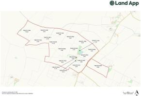
Farmland - The farmland is contained within 17 enclosures comprising 14 arable fields extending to about 207 acres (83.69 ha) and three permanent grass fields approximately 16 acres (6.58 ha). All of the fields bar one contained within the ring boundary to the west side of Chediston Road most have the have the benefit of hedged boundaries.
The Schedule of Areas are available in our brochure.
Cropping History - The cropping history for the last 4 years is available from the agents upon request.
Soil Classification - The soils are classified by the Soil Survey of England and Wales as being principally Hanslope series. These are generally described as slowly permeable calcareous clayey soils.
Land Classification - The land is shown as grade 3 on the Provisional Ministry of Agriculture Land Classification Map for the Eastern Region.
Method Of Sale - The properties are offered for sale freehold via private treaty as a whole or in two lots with vacant possession upon complete.
Exchnage Of Contracts And Completion - Exchange should take place within 21 days after receipt by the Purchaser’s Solicitor of the draft contract. A deposit of 10% of the purchase price will be payable on the exchange of contracts. If early entry is required then Purchasers will be asked to pay an additional 10% at that stage.
Holdover - A holdover provision will be required by the Vendors to enable them to conduct a sale of Machinery and Equipment at Priory Farm on a date to be agreed.
Basic Payment Scheme (Bps) - The land is registered on the Rural Land Register. The Vendor will receive and retain the delinked payments in respect of the land.
Environmental And Woodland Grant Schemes - Both farms are entered into a Countryside Stewardship Scheme which expires on the 31st December 2025. The Purchaser will be expected to indemnify the Vendor against any breeches of cross compliance with the scheme up to the 31st December 2025. The Vendor will receive and retain the Countryside Stewardship Scheme payment for 2025.
Land Drainage - We have found plans that show the majority of the land at both farms was comprehensively drained in 1974. The plans are available for inspection at our Harleston Office by appointment.
Services - Mains water, electricity and private drainage system connected to Chapel Farmhouse. Mains electricity and borehole connected to Priory Farm buildings (not tested).
Statutory Designation - The land lies within Surface Water Nitrate Vulnerable Zones.
Outgoings - A general drainage charge is payable on the land to the Environment Agency.
Vat - Should any sale of the Farm or any right attached to it become chargeable supply for the purposes of VAT, such tax should be payable by the Purchaser in addition to the contract price.
Sporting Minerals And Timber - All sporting and mineral rights and timber or timber like trees (except as reserved or to the Crown) are included in the sale.
Town And Country Planning - The Purchaser shall be deemed to have full knowledge and have satisfied themselves as to the planning matters that may affect the property.
Chapel Farmhouse is Listed Grade II.
Priory Farmhouse is Listed Grade II.
Fixtures And Fittings - All fixtures and fittings are excluded from the sale unless specifically referred to in these Particulars.
Boundaries - The Buyer(s) shall deem to have full knowledge of all boundaries and neither the Seller not the Selling Agents will be responsible for defining boundaries nor their ownership.
Plans, Areas And Schedules - These have been prepared as carefully as possible and based on Ordnance Survey data. The plans are published for illustrative purposes only and although they are believed to be correct, their accuracy is not guaranteed.
Viewings - Strictly by appointment with Durrants.
Health And Safety - The property is part of a working Farm and therefore Viewers should be careful and vigilant whilst on the holding. Please note that Chapel Farmhouse requires modernisation and refurbishment and some of the farm buildings and Chapel Farm are in poor condition. Priory Farmhouse is considered unsafe and should not be entered. Both gardens at Chapel and Priory Farmhouses are overgrown and caution is advised when viewing.
Neither the Seller nor the Selling Agents are responsible for the safety of those viewing the properties and accordingly those viewing the properties do so at their own risk.
Useful Addresses - East Suffolk Council
Riverside, 4 Canning Road, Lowestoft, NR33 0EQ
Suffolk County Council
Endeavor House, 8 Russell Road, Ipswich, Suffolk, IP1 2BX
Wayleaves, Easements And Rights Of Way - The Land is sold subject to and with the benefit of all existing rights, including rights of way, whether public or private, light, support, drainage, water and electricity supplies and other rights, easements, and all wayleaves whether referred to or not in these Particulars. Electricity lines and a pylon cross the farms.
Anti Money Laundering - In accordance with the most recent Anti Money Laundering Legislation, buyers will be required to provide proof of identity and address to the Selling Agent once an offer has been submitted and accepted (subject to contract) prior to Solicitors being instructed.
Brochures
92754 Durrants_Chapel & Priory Farm - FINAL.pdfChediston, Halesworth

NEAREST STATIONS
Distances are straight line measurements from the centre of the postcode- Halesworth Station3.1 miles
- Brampton Station5.1 miles
Notes
Disclaimer - Property reference 33906026. The information displayed about this property comprises a property advertisement. Rightmove.co.uk makes no warranty as to the accuracy or completeness of the advertisement or any linked or associated information, and Rightmove has no control over the content. This property advertisement does not constitute property particulars. The information is provided and maintained by Durrants, Property Auctions. Please contact the selling agent or developer directly to obtain any information which may be available under the terms of The Energy Performance of Buildings (Certificates and Inspections) (England and Wales) Regulations 2007 or the Home Report if in relation to a residential property in Scotland.
Map data ©OpenStreetMap contributors.