Tyley Bottom, Coombe, GL12
- PROPERTY TYPE
Land
- SIZE
Ask agent
Key features
- Approximately 17.5 Acres
- Grade 3 Land
- Permanent Pasture
- Areas of Mature Woodland
- Pole Barn & Outbuildings
- Natural Watercourse
- Far Reaching Views
- Area of Outstanding Natural Beauty
Description
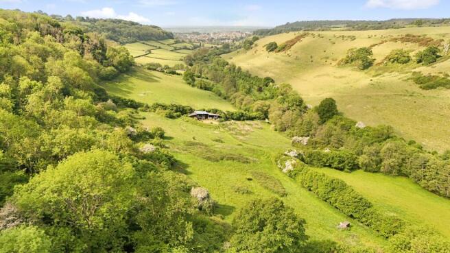
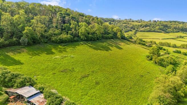
Approximately 17.5 acres of gently undulating pasture land and woodland, located at the foot of the Cotswold Escarpment, near the hamlet of Coombe.
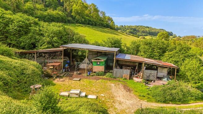
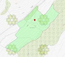
Surrounded by unspoiled open countryside, this interesting parcel of land and buildings are set in a peaceful location with beautiful views of the valley. A natural watercourse runs through the bottom of the valley and the land is accessed via a lane out of Coombe. Situated on the outskirts of the historic market town of Wotton-Under-Edge in the Cotswolds area of outstanding beauty, a section of the land is categorised as a Scheduled Monument, however further information on Historic England website is limited (list entry number: 1004859). The land is classified as grade 3 and is enclosed by natural hedge and stockproof fencing, some areas of which could use some repair work. There is a very useful pole barn measuring approximately 100’ x 40’ and additional wooden outbuildings.
Viewing Details
Please contact Country Property before viewing, both to register your interest and discuss parking and access details. Although the land has vehicular access, we request persons viewing, access the site on foot only. If unaccompanied, view during daylight hours only and carry a set of our sales particulars. Please keep any dogs on leads and remove any fouling otherwise any sheep grazing may find this unpalatable, keep any children under your direct supervision for their safety and welfare. Viewings are entirely at your own risk, neither Country Property nor the vendor accept any responsibility for any loss, damage, injury or accident arising under any circumstances.
Directions
From the centre of Wotton-under-Edge and with Saint Mary the Virgin parish Church on your right hand side, proceed out of the village along the B4058 (Coombe Road). After the sharp right hand bend, fork right on to Coombe Road, and proceed back down the hill where you will see the red brick water pumping station building in front of you. Take the left hand road hugging the houses on your left. Follow this road taking the next right. Continue on this lane around to the right and the access track to the land can be found to the left of the red roofed stone building. Please note: the first time you view the land, we suggest that you walk up the track. Please call on option 1 and we'll be happy to help, or see our What3Words guides.
What3Words Guide
We suggest walking to the land for the first time, it will take about 10 minutes and best to wear walking boots or wellies depending on weather.
Parking (What3Words)
sidelined.reserves.brand
Entrance to footpath (What3Words)
hesitate.bulbs.island
Exit of Footpath onto lane (What3Words)
reforming.necks.overlooks
Gateway entrance to the land (What3Words)
released.obscuring.decking
Pole barn in land (What3Words)
sleeping.paintings.renews
Post box at start of lane access (What3Words)
bravery.corded.outboard
Brochures
Property BrochureTyley Bottom, Coombe, GL12

NEAREST STATIONS
Distances are straight line measurements from the centre of the postcode- Cam & Dursley Station5.1 miles
About Country Property, Chipping Sodbury
73 Broad Street, Chipping Sodbury, BS37 6AD


Notes
Disclaimer - Property reference 8279b276-bf37-49f5-a559-b88b83397fa8. The information displayed about this property comprises a property advertisement. Rightmove.co.uk makes no warranty as to the accuracy or completeness of the advertisement or any linked or associated information, and Rightmove has no control over the content. This property advertisement does not constitute property particulars. The information is provided and maintained by Country Property, Chipping Sodbury. Please contact the selling agent or developer directly to obtain any information which may be available under the terms of The Energy Performance of Buildings (Certificates and Inspections) (England and Wales) Regulations 2007 or the Home Report if in relation to a residential property in Scotland.
Map data ©OpenStreetMap contributors.