
Bourton, Gillingham

- PROPERTY TYPE
Land
- SIZE
384,635 sq ft
35,734 sq m
Key features
- For Sale by Informal Tender
- About 8.83 acres
- Road Frontage
- Close to Cranborne Chase National Landscape
- Closing date for offers 12 noon Wednesday 2nd July
- FREEHOLD
Description
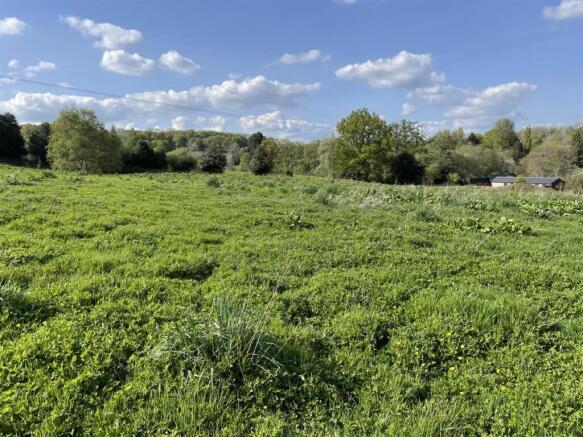
Situation - The land is situated on the northern edge of the village of Bourton, just 1.8 miles from the A303 which provides direct access to Wincanton and Mere.
Bourton provides a range of local amenities including a public house, service station and post office. Further services are available in the larger towns of Wincanton and Gillingham.
There are an extensive range of footpaths and bridleways locally, including the Stour Valley Way which provides good hacking and walking routes.
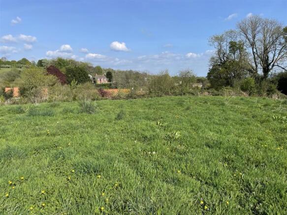
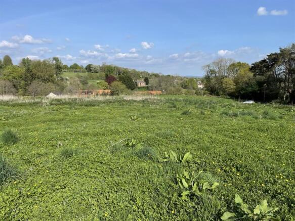
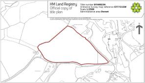
Description - The land extends to 8.83 acres within a single enclosure. The land has direct access to Kite’s Nest Lane.
The land is classified as grade 4 according to the Natural England Land Classification Maps. The soils may be described as freely draining slightly acid loamy soils.
Access - The land has direct public highway frontage to Kite’s Nest Lane.
Services - There is a mains water connection to the land. There are no other services connected.
Method Of Sale - The land is offered for sale by informal tender. The closing date for tenders is midday on Wednesday 2nd July.
The informal tender form is available from Stags. Tenders to be submitted in writing to Stags Farm Agency, 21 Southernhay West, Exeter, Devon EX1 1PR or emailed to; and marked for the attention of Patrick Ellicott.
Should an offer be accepted, Stags will require evidence of funding from the successful bidder. In addition, under Money Laundering Regulations 2017 it is a requirement for Estate Agents to perform due diligence checks on purchasers to verify their identity. This will be done by means of an on-line check undertaken by Stags. Please refer to the informal tender form. The vendor is not obliged to accept the highest or indeed any offer received.
Tenure And Possession - The land is held freehold and is available with vacant possession on completion.
Schemes - The land is not entered into any Environmental Schemes.
Local Authority - North Dorset Council (
Sporting And Mineral Rights - The sporting and mineral rights insofar as they are owned are included with the freehold.
Wayleaves & Rights Of Way - The property is sold subject to and with the benefit of any wayleave agreement and any public or private rights of way that may affect it.
A public footpath crosses the land
Plans & Boundary Fences - A plan which is not to scale, is included with these sale particulars for identification purposes only.
Viewing - By appointment only. Please contact Stags Farm Agency on or email
Directions - From the A303, take the exit onto the B381. Turn right onto New Road and follow the road for approximately 1.5 miles, turn left onto Bridge Street and the land is located on the left-hand side with access from Kite’s Nest Lane.
What3words ///chum.shield.flushes
Warning - Farms and land can be dangerous places. Please take care when viewing the property, particularly in the vicinity of farm buildings and livestock.
Brochures
Bourton, GillinghamBourton, Gillingham

NEAREST STATIONS
Distances are straight line measurements from the centre of the postcode- Gillingham (Dorset) Station3.8 miles


Notes
Disclaimer - Property reference 33938416. The information displayed about this property comprises a property advertisement. Rightmove.co.uk makes no warranty as to the accuracy or completeness of the advertisement or any linked or associated information, and Rightmove has no control over the content. This property advertisement does not constitute property particulars. The information is provided and maintained by Stags, Exeter. Please contact the selling agent or developer directly to obtain any information which may be available under the terms of The Energy Performance of Buildings (Certificates and Inspections) (England and Wales) Regulations 2007 or the Home Report if in relation to a residential property in Scotland.
Map data ©OpenStreetMap contributors.