Burnhouse Moor, South Lanarkshire ML12
£0.34 per sq ft
Business rates & charges may apply

- SIZE AVAILABLE
13,993,070 sq ft
1,300,000 sq m
- SECTOR
Land for sale
Key features
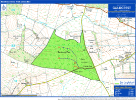
- Burnhouse Moor - 130.54 Hectares / 322.56 Acres
- Viewing is strictly by appointment
- A prime commercial forest with excellent access and a large volume of mature timber. An exceptional investment opportunity.
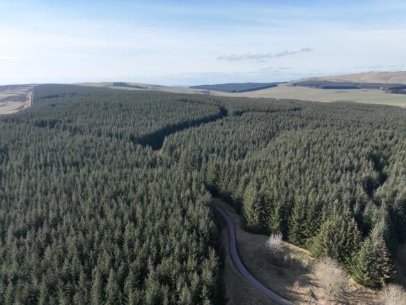
- Highly productive and commercial, 88% of the forest is stocked with Sitka spruce
- Mature timber profile: Average crop age of 41
- Recent timber survey suggests yield classes up to 28
- Some stands measured at over 900 m ³ per hectare
- Strategically positioned close to major timber processors
Description
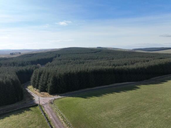
This forest enjoys an excellent position near the A74 and A702, approximately 6 miles north of Abington. The area is renowned for its outstanding growing conditions and offers swift, convenient access to a wide range of competitive timber buyers across South Scotland.
The property is identified on the location and sale plans included in these particulars. For navigation, the nearest postcode is ML12 6HU and the What3Words location is rabble.ethic.puppets.
Access
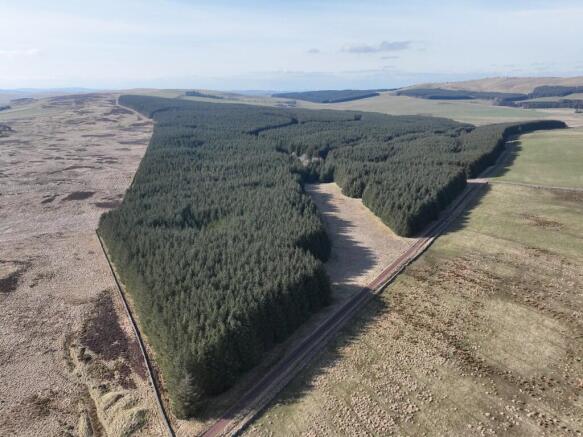
Access to Burnhouse Moor is taken from an unnamed public road, with timber extraction taken via the B7055, a designated Agreed Timber Transport Route, offering efficient connections to nearby sawmills.
The main access gate is marked A1 on the sale plan. From this point, a well-constructed internal forest road extends through the property to points A2 and A3. There is also plenty of easily won stone available on site to support future road construction and ongoing maintenance.
Description
Burnhouse Moor is a high-quality, first-rotation commercial forest, exceptionally well located and established between 1985 and 1986. The crop is predominantly Sitka spruce, a proven commercial species in the region, which has produced an impressive volume of timber.
A recent timber assessment estimates the forest currently holds approximately 80,000 cubic metres of timber, with an average of 685 m³ per conifer hectare. Notably, some coupes exceed 900 m³ per hectare, underlining the forest's productivity. The survey also indicates yield classes ranging from YC 20 to YC 28, reflecting strong growth potential and commercial value.
The majority of the timber is now mature and may be considered ready for harvesting. Alternatively, it could be retained to take advantage of further volume growth over the next 3 to 5 years.
Looking ahead, the second rotation is expected to benefit from improved tree genetics and enhanced ground conditions, with the potential for higher yield classes and increased productivity.
Sporting Rights
Sporting rights are included in the sale. The current owner has in place a deer management agreement which runs until June 2025.
Boundaries
The property is bounded by a stock fence maintenance with the neighbouring land owners is on mutual basis.
Mineral Rights
Mineral rights are included so far as the seller has right thereto.
Wayleaves & Third-Party Rights
The property will be sold with the benefit of, and subject to, all existing rights and burdens within the Land Certificate.
Designations
We are not aware of designations impacting the property. Interested parties should carry out their own searches.
Brochures
Burnhouse Moor, South Lanarkshire ML12

NEAREST STATIONS
Distances are straight line measurements from the centre of the postcode- Lanark Station7.7 miles
Notes
Disclaimer - Property reference BHM. The information displayed about this property comprises a property advertisement. Rightmove.co.uk makes no warranty as to the accuracy or completeness of the advertisement or any linked or associated information, and Rightmove has no control over the content. This property advertisement does not constitute property particulars. The information is provided and maintained by GOLDCREST LAND & FORESTRY GROUP LLP, Edinburgh. Please contact the selling agent or developer directly to obtain any information which may be available under the terms of The Energy Performance of Buildings (Certificates and Inspections) (England and Wales) Regulations 2007 or the Home Report if in relation to a residential property in Scotland.
Map data ©OpenStreetMap contributors.