

Witheridge, Tiverton

- PROPERTY TYPE
Land
- SIZE
1,305,493 sq ft
121,284 sq m
Key features
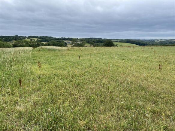
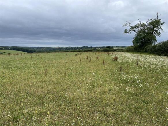
- South-Facing Arable Land
- 29.97 Acres (12.12 Hectares)
- Direct Road Access
- Frontage to the Little Dart River
- Additional Land Available Nearby
- For Sale by Private Treaty
- FREEHOLD
Description
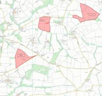
Situation - The land lies in an accessible part of north Devon, near to the north / mid Devon border and with very easy access to the A361 (North Devon Link Road) at Stonelands Cross 4.2 miles away.
The village of Rackenford lies 2.5 miles to the north and Witheridge lies 2.5 miles to the west.
The market towns of Tiverton (10 miles) and South Molton (11 miles) are nearby and the A361 (North Devon Link Road) provides a direct link to the M5 motorway at Junction 27.
Description - The land totals approximately 29.97 acres (12.12 hectares) and includes four south-facing fields which have been used to grow grass and maize. These fields run down to the Little Dart River which flows along the southern boundary and there is direct access to a public highway which forms the northern boundary.
The land lies at between 175m and 220m above sea level and the soils are described as slowly permeable seasonally wet acid loamy and clayey soils.
Additional Land Available Nearby - LOT 1 (Newland Manor) totals approximately 33.97 acres (13.74 hectares) and comprises two grass fields, one which is gently sloping and east-facing and the other sloping and facing north-east. In addition there is a small copse of deciduous trees on the eastern boundary and this lot has direct access to a public highway.
LOT 3 (Piley) totals approximately 47.31 acres (19.14 hectares) and is an attractive run of south-facing grass land with access via Piley Lane (a stone track). There are seven enclosures and the land is used for mowing and grazing with the Little Dart River flowing along the southern boundary.
Services - There are no mains services connected but there is direct access to the Little Dart River.
Tenure - The land is owned freehold and is registered on the Land Registry.
Vacant possession will be available from the completion date.
Land Management - The land is currently entered into a Sustainable Farming Incentive (SFI) agreement. The options are SAM 1 (Soil assessment and management).
Local Authority - North Devon District Council.
Designations - The land is within a Nitrate Vulnerable Zone (NVZ).
Boundary Plan - A plan, which is not to scale and is not to be relied upon, is attached to these particulars. Purchasers must satisfy themselves by inspection or otherwise as to its accuracy.
Sporting & Mineral Rights - The sporting and mineral rights insofar as they are owned, are included with the freehold of the whole farm.
Wayleaves & Rights Of Way - The property is sold subject to and with the benefit of any wayleave agreements and any public or private rights of way or bridleways etc.
There are no public footpaths or bridleways passing through any of the lots.
Viewing - Please contact Stags to arrange a viewing appointment. Tel: . Email: .
Directions - From Tiverton on the A361 North Devon Link Road proceed west towards Barnstaple for approximately 5.5 miles and upon reaching Stoneland Cross, take the left turn.
At the following T-Junction turn right towards Rackenford. Continue for 0.1 miles and at Tidderson Cross turn left signed towards Nomansland. Stay on this road for 2.2 miles and at Elworthy Cross turn right towards Witheridge and after a short distance (0.1 miles) you will reach Crow Lane Cross.
Turn right at Crow Lane Cross towards Rackenford and continue for 1.1 miles until reaching Queen Dart Cross. Turn left towards Witheridge and the entrance gate will be found on the left.
What3words - Reference/// salad.broadens.january
Warning - Farms and land can be dangerous places. Please take care when viewing the property, particularly in the vicinity of farm buildings and livestock.
Disclaimer - These particulars are a guide only and should not be relied upon for any purpose.
Brochures
Witheridge, TivertonWitheridge, Tiverton

NEAREST STATIONS
Distances are straight line measurements from the centre of the postcode- Lapford Station8.8 miles


Notes
Disclaimer - Property reference 34042905. The information displayed about this property comprises a property advertisement. Rightmove.co.uk makes no warranty as to the accuracy or completeness of the advertisement or any linked or associated information, and Rightmove has no control over the content. This property advertisement does not constitute property particulars. The information is provided and maintained by Stags, Exeter. Please contact the selling agent or developer directly to obtain any information which may be available under the terms of The Energy Performance of Buildings (Certificates and Inspections) (England and Wales) Regulations 2007 or the Home Report if in relation to a residential property in Scotland.
Map data ©OpenStreetMap contributors.