
Derby, Derbyshire
- PROPERTY TYPE
Land
- SIZE
12,398,047 sq ft
1,151,817 sq m
Key features
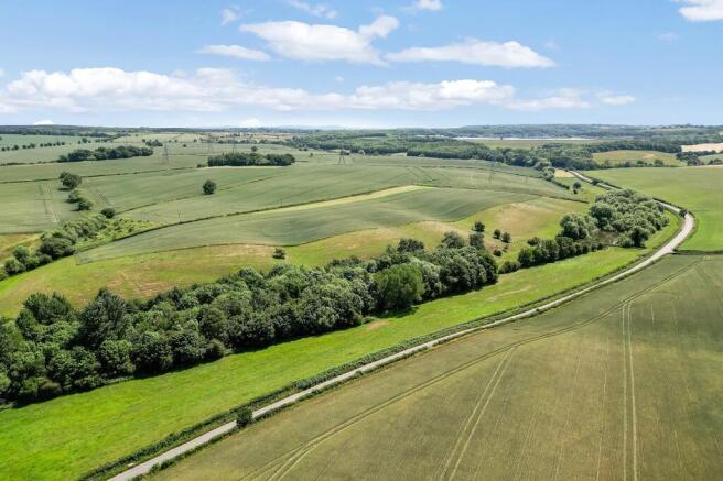
- A desirable block of principally Grade 2 arable land in a ringfence
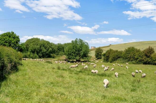
- Grassland and woodland
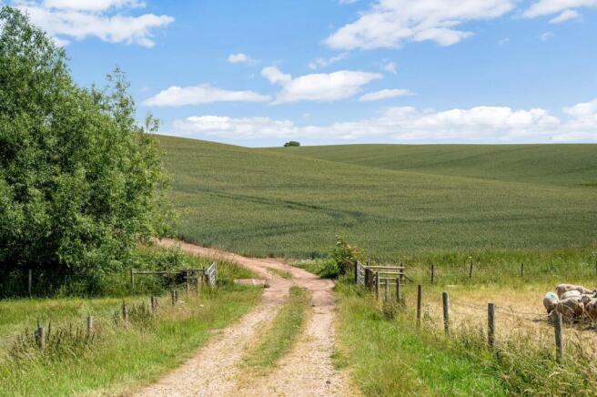
- Excellent highway access
- Good internal access tracks
- Extending in all to about 284.62 acres (115.18 ha)
- Vacant Possession available, subject to grazing licence in part
- For sale by private treaty as a whole
Description
Extending to approximately 284.62 acres (115.18 ha) in all.
Situation & Description
The land is positioned to the southeast of the highly regarded village of Repton in South Derbyshire and to the north of Foremark Reservoir.
The land benefits from multiple highway access points along the western boundary off Repton Road, and via a right of way over third party land, from Repton Road along a trackway to the northwest of the holding.
The land comprises a ringfenced predominantly arable holding which is undulating in nature. The permanent grassland along the western boundary is utilised for livestock grazing and is generally well fenced with post and wire fencing. The arable land is generally bound by mature hedgerows.
The holding has previously formed part of a small shoot with the woodland split into shelter belts across the land providing game cover.
The arable land is capable of supporting a range of cereal crops with good yields produced, and the land is generally well drained. The land is currently cropped with a second wheat.
Services
Prospective purchasers must satisfy themselves as to the availability of services and any future connections.
Tenure
The property is to be sold freehold with vacant possession, subject to a grazing licence over the grassland.
Ingoing Crop Valuation
Subject to date of sale completion, an ingoing valuation may be required.
Method of sale
The land is offered for sale by private treaty and is available as a whole.
Please note: The vendors reserve the right to conclude the sale by any means at their discretion and the Vendors are not obliged to accept the highest or indeed any offer submitted.
Local Authority
South Derbyshire District Council and Derbyshire County Council
Public Rights of Way, Wayleaves and Easements
The property is sold subject to all rights of way, wayleaves and easements whether or not they are defined in this brochure.
Plans and Boundaries
The plans within these particulars are based on Ordnance Survey data and provided for reference only. They are believed to be correct but accuracy is not guaranteed. The purchaser shall be deemed to have full knowledge of all boundaries and the extent of ownership. Neither the vendor nor the vendor’s agents will be responsible for defining the boundaries or the ownership thereof.
Overage
The property is subject (in part) to an existing overage in favour of a previous owner, reserving 30% of any uplift in value for a period of 50 years (excluding any agricultural and/or equestrian use of the property). The overage expires in January 2062.
The land will be sold subject to a new uplift provision which will specify that 20% of any increase in value due to development (as defined in Section 55 of the Town and Country Planning Act 1990) will be payable to the Vendors or their successors in title should such development occur within 20 years from the date of completion.
The uplift will be payable upon implementation or on a future sale with the benefit of a planning consent but shall not be triggered by any development for agricultural and/or equestrian purposes.
The Vendor is willing to consider offers based on varied overage terms to the above, including offers free of the new uplift provision.
VAT
We understand the property is opted to tax and therefore VAT will be payable in addition to the purchase price.
Mineral, Sporting, and Timber Rights
The sporting and timber rights will be transferred with the freehold title where owned. The mineral rights are reserved to a third party along with powers of working. Compensation provisions are provided for.
We understand the sporting rights are let under an annual licence.
Restrictive Covenants
The property is subject to a restrictive covenant not to cause any nuisance, annoyance or disturbance to a previous owner or their lessees, tenants or occupiers of any property under their ownership in the area.
Land Quality and Soil Type
The land is classified as principally grade 2 with a very small section classified grade 3.
The soil type according to the LandIS interactive map powered by DEFRA and Cranfield University describes the soil as predominantly Soilscape 6 described as freely draining slightly acid loamy soils.
Around the edge of the land block a proportion of the land is classified as Soilscape 10 freely draining slightly acid sandy soils.
Nitrate Vulnerable Zone (NVZ)
The Property lies within an NVZ Area and is subject to the usual restrictions.
Basic Payment Scheme and Environmental Schemes
The land has historically been registered for payments under the Basic Payment Scheme and all de-linked payments relevant to the land will be retained by the Vendors.
The farmland is entered into a Sustainable Farming Incentive scheme. On completion of the sale this agreement shall be terminated.
Part of the farmland is within a Countryside Stewardship Scheme until 2028. The options include GS2 - Permanent grassland with very low inputs and AB9 - Winter bird food.
The purchaser/s will be obliged to take over the relevant stewardship options upon completion.
Flood Risk
A small area of land along the brook to the western boundary falls within flood zone 2 and 3.
Viewings
Viewings of the land may be undertaken during daylight hours only and with a copy of these particulars to hand. Viewers must confirm the time of their inspection to the selling agent prior to arrival. Please note the property is a working farm and viewers must take precautions with livestock and potential farm machinery on the property.
Directions
Postcode – DE65 6EF
what3words – ///thud.metals.adapt
Brochures
ParticularsDerby, Derbyshire

NEAREST STATIONS
Distances are straight line measurements from the centre of the postcode- Willington Station2.3 miles


Notes
Disclaimer - Property reference ADZ250356. The information displayed about this property comprises a property advertisement. Rightmove.co.uk makes no warranty as to the accuracy or completeness of the advertisement or any linked or associated information, and Rightmove has no control over the content. This property advertisement does not constitute property particulars. The information is provided and maintained by Fisher German, Covering the Midlands. Please contact the selling agent or developer directly to obtain any information which may be available under the terms of The Energy Performance of Buildings (Certificates and Inspections) (England and Wales) Regulations 2007 or the Home Report if in relation to a residential property in Scotland.