Fiddler Hall Farm, Newby Bridge, Ulverston, Cumbria, LA12
- PROPERTY TYPE
Land
- SIZE
2,829,222 sq ft
262,844 sq m
Description
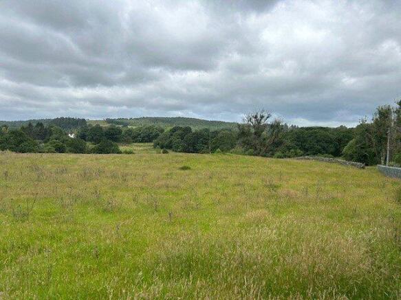
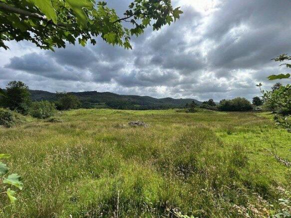
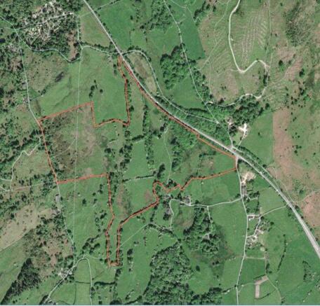
Announcement of the sale by Private Treaty of approximately 64.95 acres of freehold agricultural, grazing and pastureland , within the Lake District National Park, with the benefit of vacant possession on completion
Having been in the same family ownership for many years, this is a rare chance to purchase sought after farmland in a popular South Cumbrian location.
The land is located to the south of Windermere and the west of Kendal and the South-West of the A590 road.
Due to the size and location, we believe it will be of high interest to a variety of individuals, from local land and property owners to investors and farmers.
Lot 1 comprises large parcels of approximately 64.95 acres of grazing and pastureland, in an excellent location with the benefit of roadside access off Back Lane and Hazelrigg Lane. The field enclosures are of a good size throughout the lot.
The land occupies a pleasant position with elevated, open views towards the local Lake District Fells and rolling countryside.
Method of Sale
The property is to be sold by Private Treaty, with all offers to be put forward via UAM Property.
Tenure
The Land is sold freehold and with vacant possession granted upon completion.
Environmental Schemes
We have been advised that the land is not subject to any Environmental Schemes.
Wayleaves/Easements
The property is sold subject to, and with the benefit of, all rights of way, whether public or private, any existing or proposed wayleaves, easements or quasi easements, whether referred to within these particulars or not.
Right of way over Barn Owls, Fiddler Hall to access Lot 2.
Sporting Rights
The sporting rights on all of the lots, are included with the sale.
Water
No mains water, all natural sources.
Boundaries
Details relating to boundary maintenance responsibilities, can be obtained from the agents upon request.
Local Authority
Westmorland and Furness Council
Designations
Lake District National Park
Inspections
During normal business hours with a set of particulars to hand having due regard to the closing of gates and safety of any grazing livestock.
Money Laundering Regulations
On the acceptance of an offer, purchasers should be aware we must undertake checks in connection with Money Laundering Obligations as part of the new Money Laundering Regulations (The Money Laundering, Terrorist Financing and Transfer of Funds (Information on the Payer) Regulations 2017) and provide photographic ID, i.e. passport/driving licence and proof of address i.e. utility bill/council tax dated within the past 3 months.
Health and Safety
Viewers should bear in mind the risk associated with agricultural land, as well as any livestock or wildlife that may be present at time of viewing.
We recommend all viewers to wear appropriate clothing and footwear to minimise the risks associated with viewing land and property.
Sale Plans
The plans have been prepared by the Agents for the prospective purchasers and are for identification purposes only and are not to scale. They are considered to be correct, but any error or misstatement shall not affect the sale. Purchasers must satisfy themselves as to their accuracy.
Particulars
Particulars written July 2025. Photographs taken July 2025.
Directions
Follow the A590 to the Newby Bridge roundabout, continuing in the direction of Kendal and past the Esso petrol station on your Right. After a short distance, the land can be found on the right-hand side, parallel to the A590. The land can also be accessed from Canny Hill, along Hazelrigg Lane and also Back Lane
WHAT3WORDS
///////////flying.conveying.nodded
Fiddler Hall Farm, Newby Bridge, Ulverston, Cumbria, LA12

NEAREST STATIONS
Distances are straight line measurements from the centre of the postcode- Grange-over-Sands Station5.0 miles
- Arnside Station6.5 miles


Notes
Disclaimer - Property reference UAM250016. The information displayed about this property comprises a property advertisement. Rightmove.co.uk makes no warranty as to the accuracy or completeness of the advertisement or any linked or associated information, and Rightmove has no control over the content. This property advertisement does not constitute property particulars. The information is provided and maintained by UAM Property, Ulverston. Please contact the selling agent or developer directly to obtain any information which may be available under the terms of The Energy Performance of Buildings (Certificates and Inspections) (England and Wales) Regulations 2007 or the Home Report if in relation to a residential property in Scotland.