
Land At East Kirkland Farm, Wigtown, Newton Stewart, Dumfries and Galloway, DG8
- PROPERTY TYPE
Land
- SIZE
8,450,640 sq ft
785,091 sq m
Key features
- Silage land and saltmarsh grazings
- 57.23 acres silage
- 137.19 acres merse / saltmarsh
- Class 4(1) and 6(1)
- For sale as a whole
Description
Description
SITUATION
Land at East Kirkland is situated on the River Cree estuary forming part of Wigtown Bay. Nearby Wigtown is famed for its National Book Town status and boasts more than a dozen bookshops along with a popular festival which takes place annually in September. The town also provides a small supermarket, post office, playparks, bowling green, golf club, numerous community facilities, cafes and restaurants as well as nursery and primary schooling. The market town of Newton Stewart is 7 miles distant where there is a livestock market, as well as a range of business services, supermarkets and shops. Wigtownshire is a genuinely rural area of Scotland, well known for dairy and livestock farming, magnificent countryside and dramatic coastline. Wigtown bay forms part of a local nature reserve, reflecting its nature conservation value across the salt marshes surrounding the estuaries of the Rivers Cree and Bladnoch. Country sports in the area include fishing on the nearby rivers, as well as pheasant and partridge shooting on surrounding estates and wildfowling on the salt marshes.
Communication links in the area are good with railway stations in Stranraer (31 miles), Barrhill (25 miles) and Dumfries. The A75 is accessible at nearby Newton Stewart, linking to the M74 in the east of the region. The nearest international airports are at Prestwick (about 65 miles) and Glasgow (about 95 miles). Cairnryan lies about 34 miles to the west and is the main ferry terminal for Northern Ireland with services to both Larne and Belfast.
DESCRIPTION
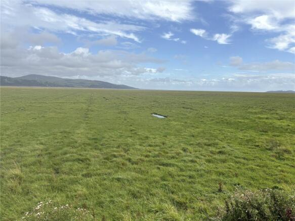
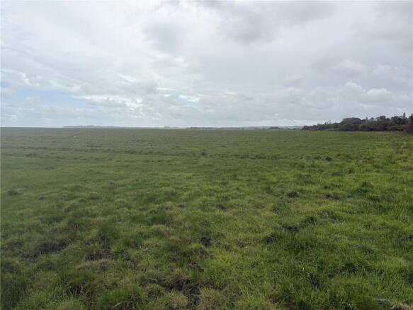
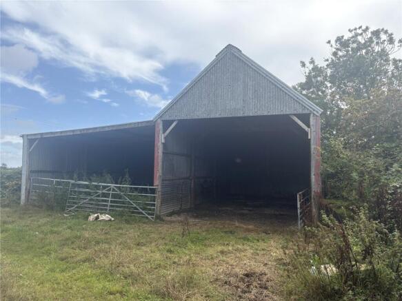
Land at East Kirkland extends to 194.42 acres (78.68 hectares) in total and is accessed from the minor public road abutting the western boundary. The land is split into 4 field enclosures which are used for grazing and silage, plus an extensive expanse of salt marsh utilised for spring and summer grazing. The whole is split into approximately 57.23 acres (23.16 hectares) of silage / grassland and 137.19 acres (55.52 hectares) of merse land / salt marsh. The land is generally level being about 5m above sea level, and is classified by the James Hutton Institute as a mixture of classes 4(1) and 6(1) on the Land Capability for Agriculture scale. The parcel is a ring fenced block enclosed by post and wire fencing, with exception of the eastern boundary. There is a timber framed barn with corrugated iron cladding which sits at the end of the track. There are a number of water troughs which are mains fed (metered via East Kirkland Farm).
Acreage: 194 Acres
Directions
Directions
From the A75, follow signs to Newton Stewart. At the Newton Stewart roundabout, exit the A75 onto the A714 towards Wigtown. After about 5.5 miles turn left and at the next junction turn left again – the fields are now on your right. The postcode is DG8 9TA. What3words: former.sweep.grudging
Land At East Kirkland Farm, Wigtown, Newton Stewart, Dumfries and Galloway, DG8

NEAREST STATIONS
Distances are straight line measurements from the centre of the postcode- Barrhill Station20.6 miles

About Savills Rural Sales, Dumfries
Monreith House, The Crichton Glencaple Road Dumfries Dumfries and Galloway, DG1 4ZZNotes
Disclaimer - Property reference DFR250033. The information displayed about this property comprises a property advertisement. Rightmove.co.uk makes no warranty as to the accuracy or completeness of the advertisement or any linked or associated information, and Rightmove has no control over the content. This property advertisement does not constitute property particulars. The information is provided and maintained by Savills Rural Sales, Dumfries. Please contact the selling agent or developer directly to obtain any information which may be available under the terms of The Energy Performance of Buildings (Certificates and Inspections) (England and Wales) Regulations 2007 or the Home Report if in relation to a residential property in Scotland.