

Land At Buckton, Bridlington, East Yorkshire, YO15
- PROPERTY TYPE
Land
- SIZE
10,058,004 sq ft
934,420 sq m
Key features
- Predominantly free draining Grade 3 arable land
- Ring fence block
- About 223 acres of arable capable of producing cereal and root crops
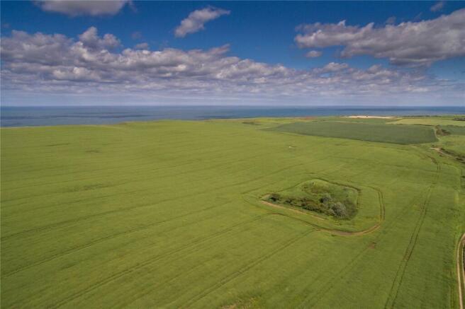
- Cliff top and SSSI land providing bio-diversity opportunities and stewardship income
- Road frontage
- In all about 230.90 acres
Description
Description
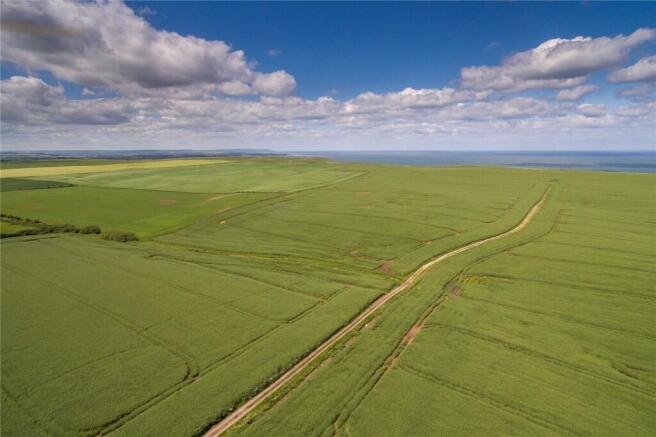
230 acres of predominantly free draining arable land, together with grassland. The land is situated in an attractive coastal location on the immediate edge of Buckton village. In all there is around 223 acres of arable land which comprises free draining soils capable of producing high yielding arable and root crops.
The land has the benefit of good road frontage and access from three points. The land gently undulates and is free draining, with the majority of the land comprising large open fields suitable for modern farm machinery.
LOCATION & SITUATION
The land is situated with access off the B1229 to the immediate west of Buckton village. Buckton and the adjoining Bempton village is a rural east coast village situated approximately 4 miles north east of Bridlington. There is a basic range of services including primary school, shops and public houses, a larger selection of services are available in the seaside town of Bridlington.
The area is popular with tourists, being located approximately 4 miles to the north of the seaside resort of Bridlington and 15 miles to the south of Scarborough.
A full range of services and amenities including primary and secondary schools, sporting and leisure facilities, shops and restaurants can be found in the traditional seaside resort of Bridlington located within 4 miles of the subject property.
Acreage: 230.9 Acres
Additional Info
Tenure - The freehold of the land is offered for sale with vacant possession on completion. The vendor currently operates a contract farming arrangement with a local farmer, who would have an interest in continuing an ongoing relationship with the purchaser, either on a contract farming arrangement or farm business tenancy.
Wayleaves, Easements & Rights of Way - The property is sold subject to, and with the benefit of all existing wayleaves, easements and rights of way, public and private whether specifically mentioned or not. A footpath crosses east-west along the northern boundary and cliff top.
The land benefits from a right of way over Hoddy Cows Lane and a shared access track from the B1229, west of the village. There is also access from the B1299 across neighbouring land into the most southerly parcel.
Land Classification - The land is classed as Grade 3 on the Agricultural Land Classification Map.
Basic Payment Scheme (BPS) - The land is registered on the Rural Land Registry, the seller will retain the Basic Payment (BPS) and any subsequent payments based on previous entitlements and historical claims. The purchaser will indemnify the vendor against any non-compliance from the date of completion.
Soil Type - The soils belong to the Burlingham 2 series described as “deep fine loamy soils with slowly permeable sub soils”.
Designations - The land lies within a Nitrate Vulnerable Zone (NVZ). The cliff of Flamborough Head is a designated Site of Special Scientific Interest.
Sporting & Timber - All sporting and timber rights shall be included in the sale in so far as they are owned.
Mineral Rights - All mineral rights shall be included in the sale in so far as they are owned.
Drainage - The selling agents understand the land is under drained, any plans held will be made available.
Boundaries - The vendor and vendor’s agents will do their best to specify the ownership of boundaries, hedges, fences and ditches but will not be bound to determine these.
Holdover/Growing Crops - Depending on the date of purchase, the purchaser will agree to purchase the growing crops based on standard CAAV costings at the date of completion. Alternatively, the vendor will retain holdover rights until the 2026 harvest is completed.
Services - There are no services or connections to the land.
VAT - We understand the land is not opted to tax for VAT.
Local Authority - East Riding of Yorkshire Council, County Hall, Beverley, East Riding of Yorkshire, HU17 9BA.
Access - The land has direct access to the B1229 (a public highway) and benefits from a useful internal track linking the fields.
Nearest Postcode YO15 1HX
what3words: ///hunk.with.adventure
Method of Sale - The freehold of the property is available for sale as a whole by private treaty, offers for alternative parts may be considered. All prospective purchasers are encouraged to register their interest with the joint selling agents.
Viewing - The land may be inspected at all reasonable times on foot; with a copy of these particulars. Care should be taken with open ditches and drains. Please be mindful of potential
hazards when inspecting the land and viewing is entirely at your own risk.
Brochures
Web DetailsLand At Buckton, Bridlington, East Yorkshire, YO15

NEAREST STATIONS
Distances are straight line measurements from the centre of the postcode- Bempton Station1.5 miles
- Bridlington Station4.4 miles
Notes
Disclaimer - Property reference YOR240116. The information displayed about this property comprises a property advertisement. Rightmove.co.uk makes no warranty as to the accuracy or completeness of the advertisement or any linked or associated information, and Rightmove has no control over the content. This property advertisement does not constitute property particulars. The information is provided and maintained by Savills Rural Sales, York. Please contact the selling agent or developer directly to obtain any information which may be available under the terms of The Energy Performance of Buildings (Certificates and Inspections) (England and Wales) Regulations 2007 or the Home Report if in relation to a residential property in Scotland.