
Land and Buildings At South Hill, Parsonage Lane, Staple Fitzpaine, Taunton, TA3
- PROPERTY TYPE
Land
- SIZE
1,815,581 sq ft
168,673 sq m
Key features
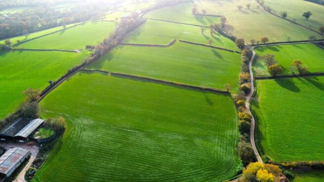
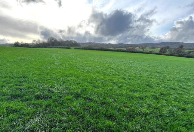
- 41.68 acres of gently sloping and productive pasture land
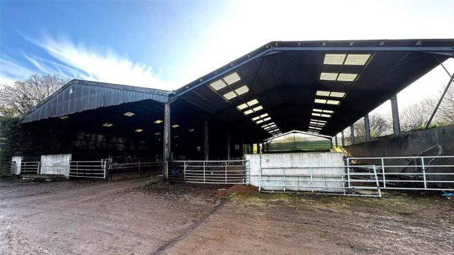
- Two Modern Agricultural Buildings
- Slurry Tank
- Blackdown Hills Area of Outstanding Natural Beauty
Description
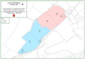
Lot 1: 19.99 ACRES (8.09 HECTARES) - Guide Price: £325,000
Lot 1, as shaded pink on the site plan, comprises approximately 19.99 acres of gently sloping, productive pasture land and the accompanying agricultural buildings. The land is enclosed with mature hedgerow boundaries and natural ditching in part. This land is split into two useful enclosures which adjoin the agricultural buildings on the eastern edge. The land benefits from direct road access from the public highway known as Parsonage Lane.
Located on the land are two useful steel framed buildings and a slurry tank, which are described further below:
Building 1 (nearest the road) is of steel framed construction with timber sleeper walls and Yorkshire boarding set beneath a fibre cement/asbestos roof and measures approximately 63.15ft x 95.62ft and includes the internal scrape and feed passage.
Building 2 (nearest the field) is again of steel frame construction with concrete panels on selected elevations and set beneath a fibre cement roof. The building measures approximately 39.90ft x 96.09ft.
Internally, both the buildings have concrete floors and provide scope for continued agricultural practice or other uses, subject to obtaining the necessary consents.
The slurry tank is located directly north of the buildings and has a base floor area of approximately 304m2, please note the tank is currently quite full so please take caution when viewing.
The vendors are retaining the ownership of the adjacent yard and the track bounding the eastern edge of the field parcel north of the buildings. Access via the yard is strictly by negotiation.
Lot 2: 21.69 ACRES (8.78 HECTARES) - Guide Price: £220,000
Lot 2, as shaded blue on the site plan, comprises approximately 21.69 acres of gently sloping productive and versatile pasture land, together with a small area of copse in the north west corner. The land is enclosed with mature hedgerow boundaries and natural ditching in part.
This land comprises two useful enclosures and benefits from direct road access from the public highway known as Parsonage.
Please see the Sales Particulars for further details pertaining to the subject property.
The land and buildings at South Hill, Somerset are located in a picturesque rural setting to the South West of the peaceful village of Staple Fitzpaine. The village offers a range of local amenities including a busy local pub and a church. The county town of Taunton is situated approximately 6.9 miles to the north of the property, providing a more extensive range of services and amenities including a wide range of shops, services and recreational opportunities. The Land and Buildings are conveniently located , being approximately 3 miles from the A358, providing easy access to the wider road network, including connections to the M5 motorway, the A30 and the A303 for broader regional travel.
The property is situated within the Blackdown Hills Area of Outstanding Natural Beauty (AONB), which is renowned for it’s abundance of wildlife and scenic landscapes.
Brochures
ParticularsLand and Buildings At South Hill, Parsonage Lane, Staple Fitzpaine, Taunton, TA3

NEAREST STATIONS
Distances are straight line measurements from the centre of the postcode- Taunton Station5.6 miles


Notes
Disclaimer - Property reference CHG250066. The information displayed about this property comprises a property advertisement. Rightmove.co.uk makes no warranty as to the accuracy or completeness of the advertisement or any linked or associated information, and Rightmove has no control over the content. This property advertisement does not constitute property particulars. The information is provided and maintained by Greenslade Taylor Hunt, Chard. Please contact the selling agent or developer directly to obtain any information which may be available under the terms of The Energy Performance of Buildings (Certificates and Inspections) (England and Wales) Regulations 2007 or the Home Report if in relation to a residential property in Scotland.
Map data ©OpenStreetMap contributors.