

Barn & Land off Milkgate, Leek Road, Waterhouses
- PROPERTY TYPE
Land
- SIZE
204,296 sq ft
18,980 sq m
Key features
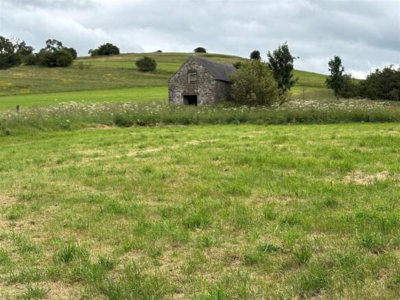
- Grassland extending to approximately 4.69 acres (1.90 hectares)
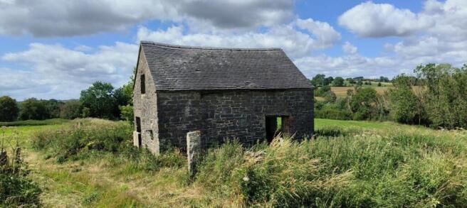
- Stone field barn measuring approximately 6.50m x 4.29 sitting centrally within the plot of land
- Barn considered to have potential for alternative leisure and tourism uses having previously had planning consent for a holiday barn conversion
- Well suited to agricultural, smallholding, equestrian, leisure/tourism uses (subject to planning) and will also appeal to those with environmental interests.
- Situated within the Staffordshire Moorlands and on the outer edge of the Peak District National Park
- Close Proximity to the Manifold Track and the village of Waterhouses
- Popular leisure and tourism area
- Mains water supply connected
Description
A viewing comes highly recommended to appreciate the tranquil setting of the land, far reaching valley views, the potential of the barn for conversion and the surrounding land which is well suited to continued agricultural, smallholding uses and the grazing of horses.
Directions - From Leek proceed out of town on the A523 signposted to Ashbourne. Continue on this road and pass through the settlements of Bradnop, Winkhill and Waterhouses. After leaving Waterhouses, take the first right turn onto the lane known as Milkgate, where the land will be found on the righthand side, identified by a Whittaker & Biggs ‘For Sale’ board.
Viewings - The barn and land may be viewed strictly on foot only during daylight hours whilst in possession of a copy of these particulars and which will constitute authority to view. Please ensure that all gates are left closed and latched or tied correctly.
Anyone inspecting the land does so entirely at their own risk and neither the selling agents nor the vendors accept any responsibility or liability for any injuries or consequential loss how so ever caused.
Tenure & Title - The property is sold freehold with vacant possession granted upon completion.
Location - Situated within the Staffordshire Moorlands, on the outer edge of the Peak District National Park and to the south of the A523 Leek to Ashbourne Road, the land is accessed off a quiet adopted lane known as Milkgate. The land is a 5 minute walk from the village of Waterhouses, halfway between the towns of Leek and Ashbourne, with both towns being approximately 8 miles away.
As you drive up the lane, the land is on the right-hand side where you will find the double gateways.
At the end of the lane and approximately 40 meters along the path away from this block of land is the entrance to the Manifold Track also referred to as the Manifold Way. This scenic valley is the former Manifold light Railway track, now with a hard surface creating a cycle route, footpath and equestrian hack trail that follows the valley bottom alongside the river Hamps and then river Manifold.
Stretching for 8 miles all the way to the village of Hulme End by Hartington, this track is an increasingly popular destination for walkers, joggers, cyclists, horse riders and highlights along the route include Thor’s Cave, Wetton Mill & tearooms, Beeston Tor and a little to the east lies Dovedale & it’s stepping stones, a well-known beauty spot, along with Ilam Country Park these National Trust attractions lead on to privately owned Tissington, home to the Well dressings. Additionally, to the south you have Alton Towers Theme Park & across to the Potteries. As a result of all these destinations and attractions, there are a number of established businesses successfully offering tourist and holiday facilities within the immediate area, inclusive of which are shepherd huts, B&B’s, lodges, farmhouse accommodation, camping and cycle hire with increasing popular demand.
Boundaries - The vendors are to erect a stockproof boundary fence between points ‘A’ to ‘B’ to ‘C’ as marked on the plan. The purchaser of the land will be responsible for its future maintenance of the fence as indicated by the inward ‘T’ marks.
Town And Country Planning Act - The property not withstanding any description contained in these particulars, is sold subject to any development plan, tree preservation order, town planning scheme or agreement, resolution or notice.
Sale Plan And Particulars - The sale plan is based on the Ordnance Survey sheet. Prospective purchasers should check the contract documents. The purchasers shall raise no objection or query in respect of any variation between the physical boundaries and the Ordnance Survey sheet plan. The plans are strictly for identification purposes only.
Money Laundering Legislation - Whittaker & Biggs must comply with Anti Money Laundering legislation. As part of the requirements, Whittaker & Biggs must obtain evidence of the identity & proof of address of potential buyers. Prior to an offer being accepted, all parties who are purchasing must provide the evidence.
Easements, Wayleaves And Rights Of Way - The land is sold subject to and with the benefit of all public and private rights of way, lights, drainage, cable, pylons or other easements, restrictions or obligations whether or not the same are described in these particulars of sale. It should be noted that the adjoining land to the east and south has a reserved right to lay a new water supply pipe alongside the roadside boundary of the land to be sold.
Access - The land has independent access off the adopted land known as Milkgate.
Brochures
BROCHURE.pdfBrochureBarn & Land off Milkgate, Leek Road, Waterhouses

NEAREST STATIONS
Distances are straight line measurements from the centre of the postcode- Blythe Bridge Station10.1 miles


Notes
Disclaimer - Property reference 34046740. The information displayed about this property comprises a property advertisement. Rightmove.co.uk makes no warranty as to the accuracy or completeness of the advertisement or any linked or associated information, and Rightmove has no control over the content. This property advertisement does not constitute property particulars. The information is provided and maintained by Whittaker & Biggs, Leek. Please contact the selling agent or developer directly to obtain any information which may be available under the terms of The Energy Performance of Buildings (Certificates and Inspections) (England and Wales) Regulations 2007 or the Home Report if in relation to a residential property in Scotland.
Map data ©OpenStreetMap contributors.