
Lot 1 - Manor Farm, Twyford SO21 1RA
- PROPERTY TYPE
Farm Land
- SIZE
1,589,069 sq ft
147,629 sq m
Key features
- SEE AND PRINT PDF SALES PARTICULARS AVAILABLE BELOW
- SEE DRONE VIDEO FOOTAGE ON THE VIRTUAL TOUR TAB
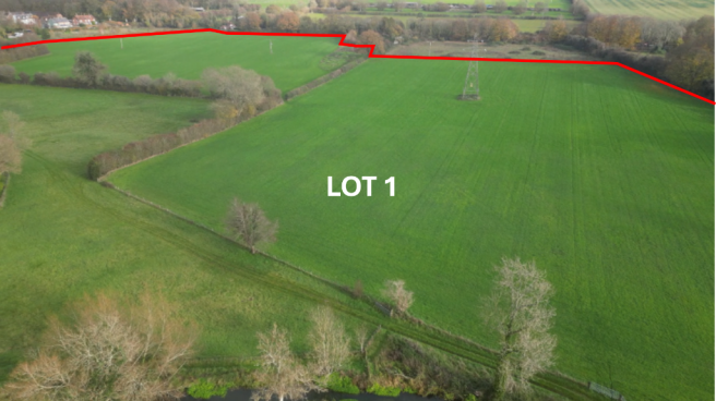
- APPROX. 36.48 ACRES IN ALL (LOT 1)
- ADDITIONAL 3 LOTS AVAILABLE
- RANGE OF MODERN FARM BUILDINGS (23,000 SQ. FT.)
- APPROX. 27.63 ACRES LAND SUITABLE FOR CROPPING
- PASTURE 6.28 ACRES
- FISHING RIGHTS - DOUBLE BANK TROUT FISHING (1,150 YARDS)
- IN THE HEART OF THE ITCHEN VALLEY WITHIN SOUTH DOWNS NATIONAL PARK
- POTENTIAL FOR ALTERNATIVE USES, SUBJECT TO PLANNING WHERE NECESSARY
Description
For a viewing of any of the land across either Lots 1, 2 or 3, or along the Segar Carrier, please call the Selling Agents to advise in advance of your visit and provide your name, mobile number and planned time and date of your visit. Then please park in the car parking at no. 3 Cottage (Lot 4) and proceed to view the land on foot. NO ACCESS TO THE RANGE OF FARM BUILDINGS PLEASE - AN ACCOMPANIED VIEWING APPOINTMENT WILL BE REQUIRED FOR THE BUILDINGS.
HEALTH AND SAFETY NOTICE: There are cows with calves grazing and housed in various parts of the Property, please keep all gates shut and avoid approaching close by to the cows and calves. No dogs allowed. Beware of deep water along Segars Carrier. Take care crossing any bridge.
VIDEO DRONE FOOTAGE: See the Selling Agent's website for further details, photographs, drone video footage is available showing the whole Property.
LOCATION: See Location Plan where the Property is identified shaded red with access by the black arrow. The Property is at the southern end of the village of Twyford. Winchester 3 miles, M3 (Junction 11) within 2 miles, Eastleigh 3½ miles, M27 (Junction 5) 5½ miles, Bishop's Waltham 7 miles.
DIRECTIONS: From Winchester Junction 11 of the M3 take the B3335 south towards Twyford. Once through the traffic lights in the centre of Twyford Village proceed south for a further 500m and then turn right into 'Manor Farm Green' with the row of Cottages. Proceed past the cottages and onto the access track where you will see the entrance gate to Manor Farm. A Public Footpath begins at this entrance gate and the range of buildings is on the left hand side approx. 100m further down the track.
From Bishop's Waltham proceed west along the B2177 to Fisher's Pond. At Fisher's Pond turn right onto B3354 signed Twyford and Winchester. Cross over the roundabout and after 2 miles at the southern edge of Twyford Village, turn left into 'Manor Farm Green' and proceed ahead to the access track to Manor Farm as described above.
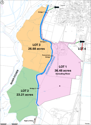
DESCRIPTION: Manor Farm is positioned on the eastern bank of the River Itchen and extends in all to a total of 86.35 acres (34.94 Ha) in a single block as shown coloured on the Site Plan. The Farm has a range of modern farm buildings well laid out and currently used for housing cattle and straw. See Building Plan and Building Schedule. The majority of the adjoining land within Lot 1 is currently in pasture and the majority has previously been farmed with arable crops. Lot 2 comprises permanent pasture suitable for grazing. Lot 3 comprises the water meadows with pond, reed and sedge beds. The length of fishing on the Segars Carrier passes through the heart of Manor Farm and forms part of Lot 1 and is not available to be purchased separately.
The Geological Survey Plan of Great Britain indicates the sub-soils to be Newhaven Chalk Formation - Chalk. The Agricultural Land Classification Map indicates the land to be of 3 and 4 Grade. The land lies approx. 20 - 35m above sea level.
Manor Farm is available either as a Whole or in up to 4 Lots:
LOT 1 - Approx. 36.48 acres (14.62 Ha) in all - Comprising a range of Farm Buildings and Yards (1.63 acres). 24.75 acres (10.02 Ha) Agricultural land currently in grass ley and previously cropped for arable.
Approx. 6.28 acres (2.54 Ha) permanent pasture below the buildings and beside Segars Carrier. Potential Right of Way for Lot 2 and Lot 3 and parking for Fishing Guests. Small block of broadleaved woodland.
The Fishing Rights along Segars Carrier. Total length of double bank Fishing 1,150 yards. Mainly fenced on either side with approx. 2-3 metres width of bank for exclusive Fishing use. Fishing Hut and Car Parking spaces beside the buildings. Foot bridge beside Fishing Hut.
LOT 2 - Approx. 23.21 acres (9.39 Ha) in all. Pasture land. Fenced. Access over Bridge 3. Additional Right of Way access from the south as identified brown on Site Plan 2. Small block of mixed woodland. Designations include SSSI and SAC.
LOT 3 - Extending in all to 26.68 acres (10.80 Ha) - Comprising Water Meadows with channels, pond, sedge and reed beds. Fenced. Access via Bridge 1 and 2. Right of Way access from the north over Bridge 1 as identified green on Site Plan 2. Designations include SSSI and SAC.
LOT 4 - No. 3 Manor Farm Green. 2 Bedroom Cottage providing approx. 989ft² accommodation with spacious Bedrooms. Brick Garage. Rear south facing Garden. 2 Parking Spaces. Mains Services. Council Tax Band D. ONLY AVAILABLE FOR SALE IF COMBINED WITH EITHER LOTS 1-3.
FARM BUILDINGS: The Farm Buildings and yard occupy a site extending to approx. 1.63 acres in all. Located at the northern end of Lot 1 with direct access off the Farm's main entrance track.
Together the range of buildings extend to over 23,000ft². The buildings are all modern steel framed and in use and the layout with adjoining yards with drainage has been well planned and currently used for a beef enterprise.
BUILDING SCHEDULE - PLEASE REFER TO BUILDING PLAN
BUILDING REF A - 45ft x 30ft (13.7m x 9.0m). 1,350ft2/123.3m2. Enclosed 3 bay steel portal frame building. Split into 3 separate units each with its own Roller Shutter door and pedestrian door. Under fibre cement roofing with cladding. Mains electricity connected (submeter for each unit).
BUILDING REF B - 80ft x 40ft (24.2m x 12.2m). 3,200ft2/295.2m2. 4 bay steel portal frame building under a corrugated concrete fibre cement roof board roof. The Northern-most bay is converted to a workshop with roller shutter door. The remainder used as an open sided agricultural storage with concrete panels to approx. 2m. Concrete floor, mains water and electricity connected height.
BUILDING REF C - 105ft x 100ft (32.0m x 30.5m). 10,500ft2/976m2. An open sided 7 bay steel portal frame building under a corrugated concrete fibre cement roof board roof. The dimensions given include 30ft (9m) wide lean-to of the same construction along the eastern side elevation. Part concrete floor, mains water and electricity connected.
BUILDING REF D - 130ft x 40ft (39.6m x 12.2m). 5,200ft2/483.12m2. An open sided 8 bay steel portal frame building under a corrugated concrete fibre cement roof board roof, the southern gable is Yorkshire boarding over concrete panelling.
BUILDING REF E - 100ft x 30ft (30.5m x 9.0m). 3,000ft2/274.5m2. A 5 bay steel portal frame building under corrugated concrete fibre cement roof board roof with earth floor. This building currently used for the storage of hay and straw is enclosed on three sides by corrugated plastic coated sheet metal.
SEGARS CARRIER - FISHING RIGHTS (Part of Lot 1): This stream is a carrier directly off the main River Itchen at its northern end and its length through Manor Farm extends to approx. 1,150yds. It would have historically functioned as a high 'drowning channel' which would have been used to flood adjoining meadows to promote early Spring grass growth for grazing.
This stretch has been operated for a number of years as an exclusive stocked fishery with Triploid Brown Trout available for a limited number of paying rods for fly fishing. Grayling are also present. Further details and Catch Records are available from Messrs Giles Wheeler-Bennett upon request.
The Portsmouth Services Fly Fishing Association (PSFFA) has managed and occupied the fishing for a number of years on an annual licence. Their ongoing involvement and management would be recommended unless a Purchaser would like the stretch vacant and in hand. THE FISHING IS NOT AVILABLE TO BE PURCHASED SEPARATELY.
NATURE CONSERVATION DESIGNATION: The majority of Lots 2 and 3 and the entirety of Segars Carrier are designated both as Sites of Special Scientific Interest (SSSI) and Site of Special Area of Conservation (SAC). See Selling Agent's website for further detail and plans.
BRIDGES: There are 3 vehicular bridges that cross the Segars Carrier as identified on the Site Plan to provide access to Lots 2 and 3. In 2010 an assessment at that time indicated that both could carry vehicles with maximum 40 tonne gross vehicle weight with maximum single allowable axel load per axel of 11.5 tonnes.
SERVICES: Mains electricity is connected to the farm buildings. 3 Phase available. Mains water is connected to the buildings and available to water troughs across Lot 1.
WAYLEAVES AND EASEMENTS: Overhead electricity pylons cross the southern parts of Lots 1 and 2 as identified on the Site Plan. 11kv overhead lines cross the Property (Lot 1). A Southern Water pipeline is laid through Lot 1.
PUBLIC RIGHTS OF WAY: A Public Footpath crosses only a short section of the Property just inside the northern boundary of Lot 1 and is fenced away as identified on the Site Plan and Building Plan. There is a Permissive Footpath from Manor Farm Green Cottages down the access track (125m) which the Vendors and their predecessors allow to connect to the Public Footpath as shown on the Building Plan.
PRIVATE RIGHTS OF WAY: A Neighbouring Landowner to the north of the buildings has Rights of Access along the main access track immediately to the north of the range of buildings through to position X on the Site Plan.
The Bishopstoke Fishing Club who have the fishing on the main River Itchen adjoining the western boundaries of Lots 2 and 3, benefit from a right of way across Lot 2 which in recent years has only been used to deliver materials to the river on one or two isolated occasions throughout the year.
SHOOTING RIGHTS: The Shooting Rights over the Property are in hand. The Property provides opportunity for rough shooting and duck.
FENCING: All the land is fenced. The western boundary of Lots 2 and 3 is fenced with post and wire and there is an obligation for the neighbouring landowner (Bishopstoke Fishing Club) to maintain this fence in a stock proof manner.
ENVIRONMENT AGENCY DIP-WELLS: There are a number of dip-wells positioned across Lot 3. They are visited once or twice a year to monitor groundwater level.
DEVELOPMENT OVERAGE: The Vendors reserve the right to retain a share of any future revenue created by any renewable energy development in connection with the Electricity Pylon line that crosses the farm.
LOCAL AUTHORITY: Winchester City Council, City Offices, Colebrook Street, Winchester SO23 9LJ.
SOUTH DOWNS NATIONAL PARK: The Property is set within South Downs National Park as outlined in yellow on the Location Plan. South Downs National Park, North Street, Midhurst GU29 9DH. The South Downs National Park Authority deals with all planning enquiries.
Brochures
Sales ParticularsLot 1 - Manor Farm, Twyford SO21 1RA

NEAREST STATIONS
Distances are straight line measurements from the centre of the postcode- Shawford Station0.7 miles
- Eastleigh Station3.4 miles
- Chandlers Ford Station3.6 miles
About Giles Wheeler-Bennett, Southampton
West Court, Lower Basingwell Street, Bishop's Waltham, SO32 1AJ
Notes
Disclaimer - Property reference ManorFarmLot1. The information displayed about this property comprises a property advertisement. Rightmove.co.uk makes no warranty as to the accuracy or completeness of the advertisement or any linked or associated information, and Rightmove has no control over the content. This property advertisement does not constitute property particulars. The information is provided and maintained by Giles Wheeler-Bennett, Southampton. Please contact the selling agent or developer directly to obtain any information which may be available under the terms of The Energy Performance of Buildings (Certificates and Inspections) (England and Wales) Regulations 2007 or the Home Report if in relation to a residential property in Scotland.