


Church Lane, Ardingly, RH17
- PROPERTY TYPE
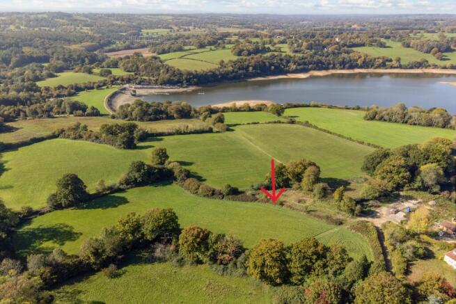
Land
- SIZE
6,000 sq ft
557 sq m
Key features
- Plot of land
- planning permission for a four bedroom three storey dwelling house
Description
Outside
Directions: Continue to the very end of Church Lane, Ardingly on to the uneven road, the entrance is on the left
Situation
Set in a stunning and hugely popular location between Ardingly and Lindfield and 3.9 miles from Haywards Heath Station. Ardingly has a village shop and an excellent bakery and Lindfield, in addition to excellent small shops also offers an extensive range of local facilities including a chemist, church, public houses, health centre and a supermarket. A wider range of facilities including a mainline station with fast and regular services to London (Victoria/London Bridge accessible within 45 mins) can be found in Haywards Heath. The M23 is just 8 miles away with access to the M25 and the rest of the motorway network, and airports at Gatwick and Heathrow.
Property Ref Number:
HAM-61433Additional Information
Agents Note: There are restrictive covenants on the land, please contact Hamptons for details.
Church Lane, Ardingly, RH17

NEAREST STATIONS
Distances are straight line measurements from the centre of the postcode- Balcombe Station2.0 miles
- Haywards Heath Station3.0 miles
- Three Bridges Station5.7 miles


Notes
Disclaimer - Property reference a1nQ500000Sq2TqIAJ. The information displayed about this property comprises a property advertisement. Rightmove.co.uk makes no warranty as to the accuracy or completeness of the advertisement or any linked or associated information, and Rightmove has no control over the content. This property advertisement does not constitute property particulars. The information is provided and maintained by Hamptons, Haywards Heath. Please contact the selling agent or developer directly to obtain any information which may be available under the terms of The Energy Performance of Buildings (Certificates and Inspections) (England and Wales) Regulations 2007 or the Home Report if in relation to a residential property in Scotland.
Map data ©OpenStreetMap contributors.