Rhos , Llandysul, SA44
- PROPERTY TYPE
Farm Land
- SIZE
Ask agent

Key features
- Rhos Llandysul - West Wales
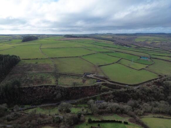
- 15 acres or thereabouts or productive pastureland
- Separate access
- Far reaching views over open countryside
- Well fenced and natural water supplies
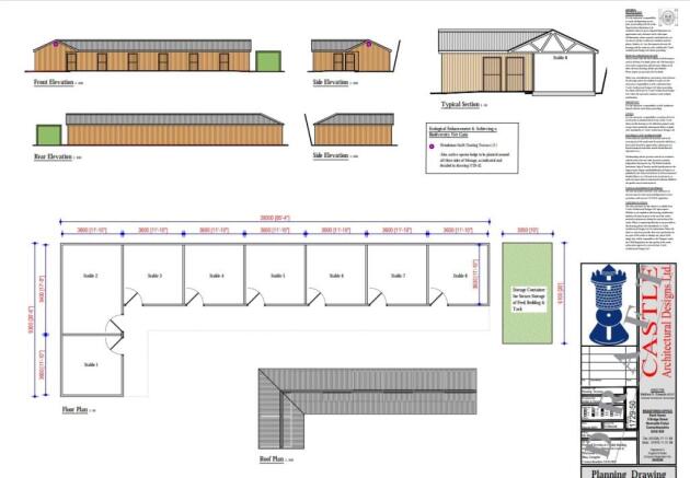
- Full planning permission and base laid down for an 8 bay 30'6" x 85'4 stable block
Description
**GUIDE PRICE - £150,000**An opportunity to acquire well situated 15 acres of pastureland**Located on the outskirts of the semi rural village of Rhos, near Llandysul**Full planning permission and base laid down for an 8 bay 30'6" x 85'4 stable block**Fully stocked proofed fenced and natural water supply**Elevated position with far reaching views over open countryside**Separate access off a council maintained roadway**Perfect for grazing or equestrian purposes**
The property is situated on the edge of the village of Rhos on the northern fringes of Carmarthenshire. The village lies in close proximity to the market towns of Llandysul and Newcastle Emlyn offering a good level of local amenities and services including community primary and secondary schools, traditional high street offerings, leisure centres, public transport connectivity, mini supermarkets, retail and employment opportunities and less than 20 minutes drive to the West Wales strategic town of Carmarthen with its Network Rail connections, university, regional hospital, connections to the M4, retail parks, industrial estates and wider connections to Mid, West and South Wales.
Natural Water supply.
GENERAL
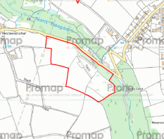
A rare opportunity of acquiring a 15 acre parcel of land, split into 4 pasture paddocks being gently sloping to sloping land.
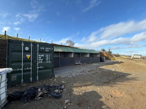
The land benefits from its own gravelled track which leads to a level area which has had planning permission granted for an 8 bay 30'6" x 85'4" stable block.
We believe that there may be further planning to add a menage on this level.
The land has undergone significant investment recently with re-fencing, new gates and a new track.
Benefiitng from its own natural water via a spring situated on the land.
The lower fields have all been planted with native broadleaf trees including beech and oak.
Perfect for equestrian purposes, or smallholders looking to keep stock.
Planning
Please note, planning permission has been obtained for the errection of a 8 bay 'L' shaped stable block measuring 30'6" x 85'4". Further information can be found on Carmarthenshire Council planning portal under referance - Pl/09603.
MONEY LAUNDERING
The successful purchaser will be required to produce adequate identification to prove their identity within the terms of the Money Laundering Regulations. Appropriate examples include: Passport/Photo Driving Licence and a recent Utility Bill. Proof of funds will also be required, or mortgage in principle papers if a mortgage is required.
VIEWING
Strictly by prior appointment only. Please contact our Aberaeron Office on or
All properties are available to view on our Website – on our FACEBOOK Page - 'LIKE' our FACEBOOK Page for new listings, updates, property news and ‘Chat to Us’.
To keep up to date please visit our Website, Facebook and Instagram Pages
Brochures
Brochure 1Rhos , Llandysul, SA44

NEAREST STATIONS
Distances are straight line measurements from the centre of the postcode- Carmarthen Station9.9 miles


Notes
Disclaimer - Property reference 29938645. The information displayed about this property comprises a property advertisement. Rightmove.co.uk makes no warranty as to the accuracy or completeness of the advertisement or any linked or associated information, and Rightmove has no control over the content. This property advertisement does not constitute property particulars. The information is provided and maintained by Morgan & Davies, Aberaeron. Please contact the selling agent or developer directly to obtain any information which may be available under the terms of The Energy Performance of Buildings (Certificates and Inspections) (England and Wales) Regulations 2007 or the Home Report if in relation to a residential property in Scotland.
Map data ©OpenStreetMap contributors.