
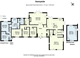
Sunnyside, Dummer RG25 2DH
- PROPERTY TYPE
Detached
- BEDROOMS
6
- BATHROOMS
3
- SIZE
2,293 sq ft
213 sq m
- TENUREDescribes how you own a property. There are different types of tenure - freehold, leasehold, and commonhold.Read more about tenure in our glossary page.
Freehold
Key features
- SEE AND PRINT PDF SALES PARTICULARS AVAILABLE BELOW
- SEE DRONE VIDEO FOOTAGE ON THE VIRTUAL TOUR TAB
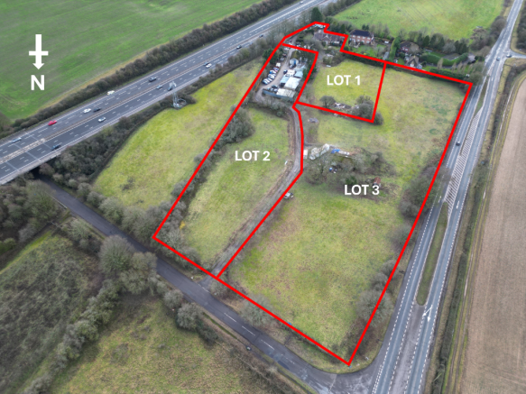
- APPROX. 6.54 ACRES IN ALL
- AVAILABLE AS A WHOLE OR IN UP TO 3 LOTS
- SPACIOUS BUNGALOW (1,857 SQ. FT.)
- SELF CONTAINED ANNEX (435 SQ. FT.)
- COMMERCIAL YARD (0.75 ACRE)
- COMMERCIAL BUILDINGS (5,841 SQ. FT.)
- 4.81 ACRES PASTURE LAND
- DEVELOPMENT AND INVESTMENT OPPORTUNITY
Description
VIEWING DATES WILL ALSO BE MADE AVAILABLE - FOR DATES PLEASE CONTACT THE SELLING AGENT.
It is essential to view the drone video footage available on the Selling Agent's website prior to contacting the Selling Agent.
VIDEO DRONE FOOTAGE: See the Selling Agent's website for further details, photographs, drone video footage.
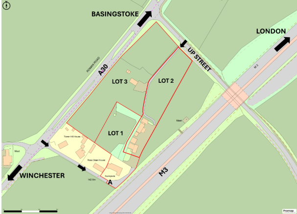
LOCATION: See Location Plan. The Property is within approx. 1.5 miles of Junction 7 of the M3, and is located 11 miles north of Winchester and within 6 miles to the south of Basingstoke.
DIRECTIONS: Please see Location Plan and use postcode RG25 2DH and What3Words - Viewing Appointments please attend at Lot 1 - The Bungalow and Annex beside A shown on the Site Plan.
DESCRIPTION: 'Sunnyside' is an interesting property extending in all to approx. 6.54 acres and a variety of features:
Spacious Bungalow extending to an estimated approx. 1,857ft2.
Attached self-contained accommodation, known as the 'Annex' extending to an estimated approx. 435ft2.
Commercial Yards and Buildings covering approx. 0.75 acres in total and with buildings amounting to approx. 5,481ft2 in total.
Pasture Land extending in all to approx. 4.81 acres.
The Bungalow and Annex are currently unoccupied.
ROAD FRONTAGE: The Property benefits from road frontage onto both the A30 Winchester to Basingstoke Road, and along 'Up Street' leading to the village of Dummer.
Along the A30 frontage the boundary of the Property is raised above the level of the road and identified by concrete fence posts.
ACCESS: The Property benefits from 2 vehicular access points:
Off the A30 over a single carriage lane shared with residential neighbours as identified by the black arrows on the Site Plan which serves Lot 1.
Off the road named 'Up Street' adjoining the northern boundary, which serves both Lot 2 and 3.
CERTIFICATE OF LAWFULNESS - There is a Certificate dated 21st March 2018 was achieved from the Local Authority for the Annex '....for the continued use of a self contained dwellinghouse, private garden and driveway parking area'. The Annex has its own Council Tax Bill.
Planning Ref: 17/04076/LDEU - Certificate of Lawfulness for Annex
COMMERCIAL YARDS AND BUILDINGS: There are various yards extending in all to approx. 0.75 acres with a range of various buildings that have been let to a variety of tenants for many years. There are approx. 4 main tenants with some sub-tenants. Some areas are open storage. See Building Plan for approximate floor areas.
We have obtained information relating to the current occupation of the various yards and buildings. This information is not yet complete and the Selling Agents are seeking to obtain confirmation of the full details in due course during the marketing campaign. The present understanding is set out below:
There are approximately 6 parties occupying various parts of the yards or buildings.
Some buildings and yards are sublet.
The yards and building have been let out for no less than 36 years.
There are currently no written agreements for any party.
The rent is paid monthly.
The total rent currently being received is in the region of £20,000 per annum.
Some of the rents will not have been reviewed for many years.
Some of the occupiers have improved the buildings and yards over the years.
LAND REGISTRY: The Property comprises the entirety of 2 Titles HP644654 and HP661062 and the Plans and Registers of each are available on the Selling Agent's website. There is also an additional area that forms part of the Property but is not currently registered, along the southern boundary to the south of the bungalow approximately identified by position A on the Site Plan.
PLANNING: The Property falls within the administrative area of Basingstoke and Deane District Council and within their Local Plan.
Please see extract from Local Plan Update 2021-2040 (Regulation 18 Draft). See Selling Agent's website for Extract.
The Property is marked by the black arrow on this plan extract
The Property is to the south of the Marydown South Housing Allocation (7,500 dwellings).
The Property is to the south of the Oakdown Farm employment site (B2 and/or B8).
Please see Selling Agent's Sales Particulars for link to whole Local Plan Update 2021 - 2040
DESIGNATIONS: There are no environmental designations that affect the Property.
PUBLIC RIGHTS OF WAY: None affect the Property.
SERVICES:
Lot 1 - Bungalow and Annex - Mains Water. Mains Electricity. Oil Fired Boiler. Septic Tank (shared between Annex and Bungalow).
Lots 2 and 3 - Commercial Yard Mains Water and Electricity (3 Phase Pole Mounted Transformer is located in the yard). No drainage.
WAYLEAVES: An overhead 11kv electricity line crosses the Property and a Pole Mounted Transformer (3 Phase) is located in the yard.
COUNCIL TAX:
Annex: Property Band = A for year 2025/2026 = £1,422.45.
Bungalow: Property Band = F for year 2025/2026 = £3,081.97.
BUSINESS RATES: To be confirmed.
DEVELOPMENT UPLIFT - LOT 3 ONLY - Subject to the level of any offer the Vendor is mindful to retain a 25% share of any uplift in value caused by future Planning Consents for any residential or commercial development that occurs on Lot 3 for a period of 25 years. This is negotiable.
LOCAL AUTHORITY: Basingstoke & Deane Borough Council, Civic Offices, London Road, Basingstoke RG21 4AH.
Brochures
Sales Particulars- COUNCIL TAXA payment made to your local authority in order to pay for local services like schools, libraries, and refuse collection. The amount you pay depends on the value of the property.Read more about council Tax in our glossary page.
- Ask agent
- PARKINGDetails of how and where vehicles can be parked, and any associated costs.Read more about parking in our glossary page.
- Driveway,Off street
- GARDENA property has access to an outdoor space, which could be private or shared.
- Front garden,Patio,Enclosed garden,Rear garden,Back garden
- ACCESSIBILITYHow a property has been adapted to meet the needs of vulnerable or disabled individuals.Read more about accessibility in our glossary page.
- Ask agent
Sunnyside, Dummer RG25 2DH

Add an important place to see how long it'd take to get there from our property listings.
__mins driving to your place
Affordability
About Giles Wheeler-Bennett, Southampton
West Court, Lower Basingwell Street, Bishop's Waltham, SO32 1AJ
Get an instant, personalised result:
- Show sellers you’re serious
- Secure viewings faster with agents
- No impact on your credit score
Notes
Staying secure when looking for property
Ensure you're up to date with our latest advice on how to avoid fraud or scams when looking for property online.
Visit our security centre to find out moreDisclaimer - Property reference SunnysideWhole. The information displayed about this property comprises a property advertisement. Rightmove.co.uk makes no warranty as to the accuracy or completeness of the advertisement or any linked or associated information, and Rightmove has no control over the content. This property advertisement does not constitute property particulars. The information is provided and maintained by Giles Wheeler-Bennett, Southampton. Please contact the selling agent or developer directly to obtain any information which may be available under the terms of The Energy Performance of Buildings (Certificates and Inspections) (England and Wales) Regulations 2007 or the Home Report if in relation to a residential property in Scotland.
*This is the average speed from the provider with the fastest broadband package available at this postcode. The average speed displayed is based on the download speeds of at least 50% of customers at peak time (8pm to 10pm). Fibre/cable services at the postcode are subject to availability and may differ between properties within a postcode. Speeds can be affected by a range of technical and environmental factors. The speed at the property may be lower than that listed above. You can check the estimated speed and confirm availability to a property prior to purchasing on the broadband provider's website. Providers may increase charges. The information is provided and maintained by Decision Technologies Limited. **This is indicative only and based on a 2-person household with multiple devices and simultaneous usage. Broadband performance is affected by multiple factors including number of occupants and devices, simultaneous usage, router range etc. For more information speak to your broadband provider.
Map data ©OpenStreetMap contributors.