Tunstall, Sittingbourne
- PROPERTY TYPE
Land
- SIZE
Ask agent
Description
Location - The land is situated in the parish of Tunstall in Swale and is located immediately south of Sittingbourne and adjoins the Ufton Court Farm Development on its northern boundary. The centre of Sittingbourne is about 1 mile distant to the north and the county town of Maidstone is approximately 9 miles to the southwest and London is approximately 40 miles to the west. Access to the A249 and junction 5 of the M2 motorway is approximately 2.5 miles to the west and junction 6 of the M20 is approximately 6 miles to the southwest via Hollingbourne.
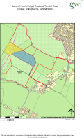
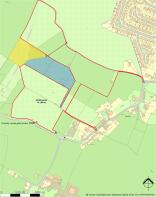
Directions - From Bredgar village, take Primrose Lane and Bredgar Lane towards Tunstall and at the junction of Hearts Delight Road, Bredgar Road and Tunstall Road, access through Tunstall Village Hall entrance and turn immediately left to arrive at point “B” on the plan. Alternatively, continue along the Bredgar/Tunstall Road and immediately past The Old School, turn left to access the land shown as point “C” on the plan. If you continue past point “C” and follow the road past Tunstall Church, access for the land can be taken from the track on the left hand side of the road where Tunstall Road bears sharp right shown as point “E” on the plan.
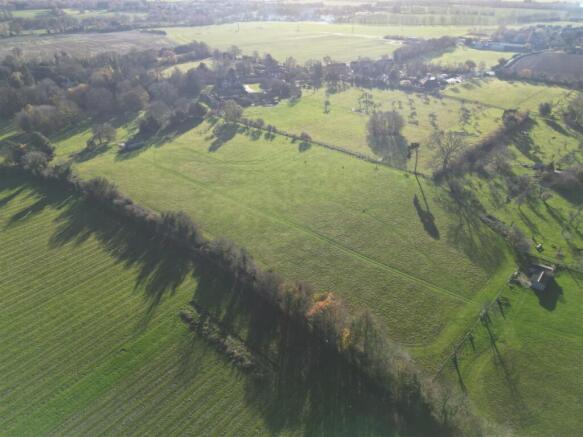
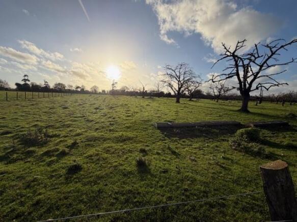
The Land - A block of mainly permanent pasture extending to approximately 35 acres (14.164 hectares) within a single ring fence with frontage onto Hearts Delight Road. There are three vehicular accesses at points “C” “E” and “H” on the plan, together with a further right of way with or without vehicles for all purposes between point “A” and point “B” on the plan. The land is subdivided into seven parcels.
Part of the land benefits from a right of way between points “E” and “F” on the plan and is also subject to rights of access between points “E”, “F” and “G” on the plan in favour of a third party owning the land shaded yellow. At access point “C” on the plan, rights of way are reserved in favour of some adjoining properties which include The Cottage, The Old School and Tunstall Stables. At access point “C” on the plan there is a right of way between points “C” and “D” on the plan in favour of a third party owning the land tinted blue.
Method Of Sale - The property is offered for sale by private treaty as a whole. Sale of part or parts might be considered. The right is reserved to take the Property to auction or by formal or informal tender at a later date.
Rights Of Way - The land is subject to public footpaths ZR140, ZR142 and ZR147. There are rights of way benefiting neighbouring land between points “C” and “D” and points “E”, “F” and “G” on the plan.
Overage - The land will be sold subject to an overage of 35% of the uplift in value of the property’s existing use for any change of use granted with planning permission or permitted development rights on the property, excepting any agricultural or equestrian use for a term of 35 years from the completion of the sale of the property.
The land will also be sold subject to an income overage of 35% of the net rental receipts of the property for any change of use granted with planning permission or permitted development rights on the property, excepting any agricultural or equestrian use for a term of 35 years from the completion of the sale of the property.
The trigger events shall be sale, commencement of development or disposal by Lease of 7 years or more. For the avoidance of doubt, the overage shall allow for multiple trigger events during the overage periods.
Services - The land has a water supply. Water supply pipes cross the property to connect to the adjoining land tinted yellow and blue on the plan.
Current Farming - The land has been permanent pasture for a number of years and grazed by sheep.
Hectares (& Acres) - The areas provided are for guidance only and are given without responsibility. Any intended purchaser(s) should not rely upon them as statements or representations of fact but must satisfy themselves by inspection or otherwise as to the areas.
Fencing & Boundaries - The purchaser(s) must satisfy themselves on the location of the boundaries from the Land Registry plans and the Vendor’s deed plans (where available).
Plans - The plans and associated acreages have been prepared for illustrative purposes and their accuracy cannot be guaranteed.
Vat - The Vendor has not made a voluntary election of the land for VAT.
Tenure - The land is to be sold freehold with vacant possession. The land is registered under titles K640554, K618559, K617661, K828419, K652149 and K134723. The land is currently being grazed under a Licence Agreement which will be brought to an end prior to exchange of contracts.
The office copy entries and title plans are available from the selling agents on request.
Viewing - The Vendors and their Agents do no accept any responsibility for accidents or personal injury as a result of viewings, whether accompanied or not. Viewings must be carried out by daylight hours only, with particulars in hand and strictly by prior appointment only with the Vendor’s sole agent. If you would like to view, please contact Stuart Mair on the contact details below.
Mineral, Sporting And Timber Rights - All mineral, sporting and timber rights are included in the sale in so far as they are owned by the Vendor.
Health And Safety - Given the potential hazards of a working farm, we would ask you to be as vigilant as possible when visiting for your own safety.
Town & Country Planning - The property is sold subject to any development plan, tree preservation order, town planning schedule, resolution or notice in force and the purchaser(s) will be deemed to have full knowledge and to satisfy himself with the provisions of any such matter affecting the property.
Rights & Easements - The property is sold subject to and with the benefit of all rights, including rights of way, whether public or private, light, support, drainage and electricity supply and other rights and obligations, easements, quasi easements and restrictive covenants and all existing and proposed wayleaves, masts, pylons, stays, cables, drains, water, gas and other pipes.
Photographs - All Photographs included were taken 1 December 2025 and 27 February 2026.
Local Authority - Swale Borough Council, East Street, Sittingbourne, Kent ME10 3HT –
Offers - Offers are invited over £500,000
Brochures
Tunstall, SittingbourneBrochureTunstall, Sittingbourne

NEAREST STATIONS
Distances are straight line measurements from the centre of the postcode- Sittingbourne Station1.6 miles
- Kemsley Station2.9 miles
- Newington Station2.9 miles
About George Webb Finn LLP, Sittingbourne
43 Park Road, Sittingbourne, ME10 1DY

Notes
Disclaimer - Property reference 34531659. The information displayed about this property comprises a property advertisement. Rightmove.co.uk makes no warranty as to the accuracy or completeness of the advertisement or any linked or associated information, and Rightmove has no control over the content. This property advertisement does not constitute property particulars. The information is provided and maintained by George Webb Finn LLP, Sittingbourne. Please contact the selling agent or developer directly to obtain any information which may be available under the terms of The Energy Performance of Buildings (Certificates and Inspections) (England and Wales) Regulations 2007 or the Home Report if in relation to a residential property in Scotland.
Auction Fees: The purchase of this property may include associated fees not listed here, as it is to be sold via auction. To find out more about the fees associated with this property please call George Webb Finn LLP, Sittingbourne on 01795 507275.
*Guide Price: An indication of a seller's minimum expectation at auction and given as a “Guide Price” or a range of “Guide Prices”. This is not necessarily the figure a property will sell for and is subject to change prior to the auction.
Reserve Price: Each auction property will be subject to a “Reserve Price” below which the property cannot be sold at auction. Normally the “Reserve Price” will be set within the range of “Guide Prices” or no more than 10% above a single “Guide Price.”
Map data ©OpenStreetMap contributors.