Land To The Rear Of 16-22 High Street, Rippingale
£8.61 per sq ft
Business rates & charges may apply
- SIZE AVAILABLE
52,272 sq ft
4,856 sq m
- SECTOR
Land for sale
Description
LOCATION
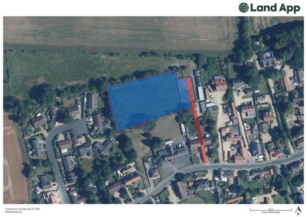
The development site is situated on the North side of High Street in Rippingale with access to the site being obtained via an entrance road to the West of 16 High Street.
WHAT 3 WORDS LOCATION: - ///comfort.placidly.engulfing
The village of Rippingale is located 5 miles north of the market town of Bourne and 16 miles north of the vibrant town of Stamford. 21 miles south of Rippingale is the city of Peterborough, which has rail connection services to London Kings Cross, taking approximately 50 minutes.
Facilities and amenities including retail, sporting, and educational are available in the nearby towns of Bourne, Sleaford, Spalding and Stamford.
DESCRIPTION
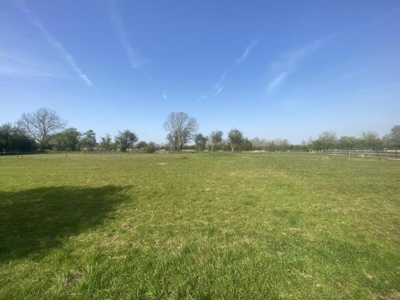
A rare opportunity to acquire a residential development site extending to approximately 4,854 sq. m. (1.20 acres), situated in a desirable village location. Outline Planning Permission was granted on the 13th February 2026 under the SKDC planning reference number 'S25/1705' for the construction of five new residential dwellings. The Decision Notice states that development should commence within 3 years of 13th February 2026.
Further details of the Outline Planning Permission can be downloaded from the South Kesteven District Council website by searching the Planning Reference (S25/1705) or by contacting R. Longstaff & Co LLP on .
ACCESS
The seller will grant a right of way over the access roadway, which is roughly shown highlighted red on the attached plan. This is subject to reasonable contributions to maintenance. The seller will also grant the buyer rights to upgrade the access roadway (at the buyer´s cost) as well as rights to lay and connect to services through/in the access roadway.
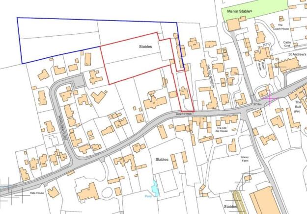
BOUNDARIES AND FENCING
Any plans are provided for indicative purposes only and are not to scale. The exact extent of the property and the access roadway will be marked on the ground and surveyed when a sale is agreed. Interested parties are responsible for familiarising themselves with the boundaries of the site. The buyer will be responsible for erecting a wooden close boarded featheredge fence with concrete posts (to at least 2.00m in height) along the East boundary of the site within six months of completion.
SERVICES
No dedicated services are connected to the land. Interested parties are advised to undertake their own investigations.
VAT
The sale will be exempt from VAT but should the sale of the land or any right attached to it become a chargeable supply for the purpose of VAT, such tax shall be payable by the buyer(s) in addition to the contract price.
PLANNING
Outline Planning Permission was granted on the 13th February 2026 under the SKDC planning reference number 'S25/1705' for the construction of five new residential dwellings. The Decision Notice states that development should commence within 3 years of 13th February 2026.
Further details of the Outline Planning Permission can be downloaded from the South Kesteven District Council website by searching the Planning Reference (S25/1705) or by contacting R. Longstaff & Co LLP on .
OTHER
METHOD OF SALE
The land is offered For Sale by private treaty, initially, as a whole, subject to contract. Perspective purchasers will be asked to comply with Anti Money Laundering regulations and to provide photographic identification in the form of a photocard driving licence or valid Passport, plus a proof of address. Further information is available from the Selling Agents.
TENURE
Freehold.
LOCAL AUTHORITIES
South Kesteven District Council (SKDC).
PARTICULARS CONTENT
R. Longstaff & Co LLP, their clients and any joint agents accept no responsibility for any statement that may be made in these particulars. They do not form part of any offer or contract and must not be relied upon as statements or representations of fact. They are not authorised to make or give any representations or warranties in relation to the property either here or elsewhere, either on their own behalf or on behalf of their client(s) or otherwise. All areas, measurements or distances are approximate. Floor plans are provided for illustrative purposes only and are not necessarily to scale. All text, photographs and plans are for guidance only and are not necessarily comprehensive. It should not be assumed that the property has all necessary planning, building regulation or other consents, and no guarantee is given for any apparatus, services, equipment or facilities, being connected nor in working order. Purchasers must satisfy themselves of these by inspection or otherwise.
Viewings are to be arranged by prior appointment. We make every effort to produce accurate and reliable details but if there are any particular points you would like to discuss prior to making your inspection, please contact our office. We suggest you contact us to check the availability of this property prior to travelling to the area in any case.
VIEWING
Viewings are strictly by appointment only with R. Longstaff & Co LLP - Bourne on . All parties enter the property entirely at their own risk. Please exercise caution in respect of your personal safety and those parties with you at all times. Neither the seller nor their Agent accept any liability for any damage to persons or their property.
Brochures
Land To The Rear Of 16-22 High Street, Rippingale

NEAREST STATIONS
Distances are straight line measurements from the centre of the postcode- Spalding Station9.7 miles
Notes
Disclaimer - Property reference 101505032821. The information displayed about this property comprises a property advertisement. Rightmove.co.uk makes no warranty as to the accuracy or completeness of the advertisement or any linked or associated information, and Rightmove has no control over the content. This property advertisement does not constitute property particulars. The information is provided and maintained by Longstaff Chartered Surveyors, Bourne. Please contact the selling agent or developer directly to obtain any information which may be available under the terms of The Energy Performance of Buildings (Certificates and Inspections) (England and Wales) Regulations 2007 or the Home Report if in relation to a residential property in Scotland.
Map data ©OpenStreetMap contributors.