
Upper Dormington, Hereford
- PROPERTY TYPE
Land
- SIZE
2,865,812 sq ft
266,243 sq m
Description
The property benefits from good roadside access, a handling pen adjacent to the main gateway, mains water, and well-stock-fenced boundaries, making it a practical and attractive block of grazing land.
For sale by Informal Tender.
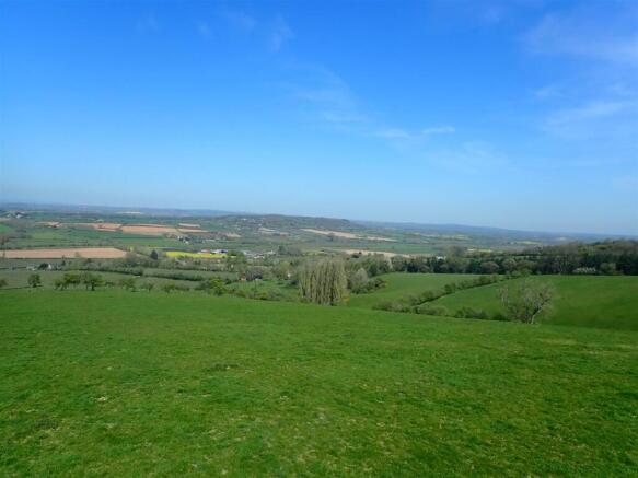
Location - The land is located within the parish of Upper Dormington, approximately 6 miles east of the City of Hereford. The town of Ledbury is located 9 miles east, the town of Ross-on-Wye is located 13 miles south and Leominster is 18 miles north. The land occupies an elevated position with fantastic far reaching views across Herefordshire.
Description - The land known as “The Hill” comprises around 62.78 acres of pasture land, together with around 2.86 acres of woodland and natural shelter belts and a small area of traditional orchard trees, extending in total to approximately 65.6 acres. Rising steeply to the southern boundary, the land occupies an elevated position with far-reaching views across the city of Hereford and towards the Black Mountains.
The property benefits from good roadside access, with a handling pen conveniently located adjacent to the main gateway. There is mains water connected, and the woodland boundaries are well stock-fenced, providing a secure and practical grazing environment.
The Hill offers purchasers a valuable block of pasture and woodland with strong agricultural and environmental appeal, together with potential for recreational or diversification enterprises, subject to all necessary consents.
The land is offered for sale by Informal Tender in one lot
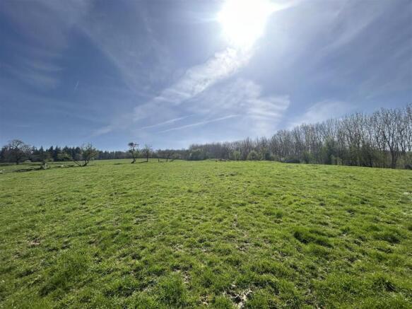
Land - The land is laid to pasture throughout, with small sections of gorse and woodland forming on the steeper sections of the land. The land has been managed on a low input grassland basis and is in good heart having been regularly grazed with cattle. The land benefits from a mains water supply.
There are several traditional apple trees located in the northern paddock adjoining the road.
Access - The land has excellent access off Clay Hill Pit Lane, a council maintained road. There is a hard track up to a single galvanised 12 ft gate providing access into the land. Adjacent to the gateway there is a fenced cattle handling pen able to accommodate a crush and handling facilities useful for gathering and loading animals.
We understand that the land also benefits from a right of way easement over the neighbouring property’s access track along the western boundary as identified by the yellow line on the plan.
Services - We understand the land is connected to mains water.
Tenure - The land is freehold with the benefit of vacant possession upon completion.
Mode Of Sale - The land is being offered for sale as a whole by Informal Tender. Prospective Purchasers should carry out their own enquiries with Herefordshire Council and other Authorities prior to making an offer on the land.
It is envisaged that no further negotiations will be entered into after the informal tender closing date. The Informal Tender Documents should be signed by the proposed purchaser(s) stating the proposed purchase price. These are to be received by Katie Bufton at Sunderlands, Offa House, St Peters Square, Hereford, HR1 2PQ by 12 noon on Thursday 21st of May 2026. Envelopes should be marked 'Informal Tender - The Hill, Dormington for the attention of Katie Bufton' and suitably sealed envelope.
The vendor reserves the right to not accept the highest offer, or any offer if they so wish. The Vendor reserves the right to accept an offer prior to the Informal Tender date.
Boundaries - The land is predominantly enclosed by woodland with further internal fence. The boundary against the road is well stock fenced and secure.
The purchaser shall be deemed to have full knowledge of the boundaries and neither the Vendors not their Agents will be responsible for defining any ownership of boundaries, hedges or fences. They will however provide whatever assistance they can to ascertain the ownership of the same.
Basic Payment Scheme & Stewardship Schemes - The land has been registered with the Rural Payments Agency (RPA) and is currently entered into the Sustainable Farming Incentive (SFI) option CLIG3 – Grassland with Very Low Nutrient Inputs. We understand that this agreement is not transferable, but it does demonstrate the land’s suitability for future schemes of this nature.
Nitrate Vulnerable Zone - The land is situated within a Nitrate Vulnerable Zone (NVZ)
Flood Zone - The land is not situated within a flood zone.
Public Rights Of Way - We understand the land is not subject to any public rights of way.
Anti Money Laundering - The purchaser will be required to provide sufficient identification to verify their identity in compliance with anti-money laundering regulations. Please note that a fee of £18 (inclusive of VAT) per person will be charged to conduct the necessary anti-money laundering checks. This fee is payable at the time of verification and is non-refundable.
Planning - No formal planning searches have been undertaken on the land. Full details of the planning history can be found on the local authority website.
Timber, Sporting And Mineral Rights - All standing timber, mineral rights and sporting rights, if owned, are included within the sale of the land.
Wayleaves And Easements - The land will be sold subject to any wayleaves, easements, public or private rights of way and covenants and all outgoings whether mentioned in these sale particulars or not.
Local Authorities And Public Utilities - Herefordshire Council, Plough Lane, Hereford, HR4 0LE
Welsh Water, Linea, Fortran Road, St Mellons, Cardiff, CF3 0LT
National Grid ED (West Midlands), Bristol, BS2 0TB
Site Plans - The plans included in the sale particulars are for identification purposes only.
Health And Safety - Please note cattle will be grazing the land, prospective purchasers should take all necessary care when inspecting wearing suitable clothing. Viewings are taken solely at the risk of those who view and neither the Agents nor the owners of the property take responsibility for any injury, however caused.
Agent's Note - The site plans included within these particulars may have been reduced in scale to assist with printing. Any interested parties should check the Title Plan before proceeding to purchase.
Important Notice - These particulars are set out as a guide only. They are intended to give a fair description of the property but may not be relied upon as a statement or representation of facts. These particulars are produced in good faith but are inevitably subjective and do not form part of any Contract. No persons within Sunderlands have any authority to make or give any representation or warranty whatsoever in relation to the property.
Fixtures & Fittings - We understand the cattle handling pen is owned by the grazier and will be removed prior to sale.
Viewing - Prospective purchasers can view the land during reasonable times and during daylight hours. We request that anyone wanting to view the land contacts the selling agents in advance.
Katie Bufton - - k.
Directions - From the city of Hereford proceed east on Hampton Park Road towards Mordiford for 4.1 miles. At the village of Mordiford turn left towards the primary school onto Dormington Lane. Proceed for 1.5 miles before turning right onto Clay Hill Pit Lane. Follow the lane to the junction and turn left. Proceed for 0.3 miles and the land will be located on your left.
What3Words///directs.countries.tribune
Brochures
Upper Dormington, HerefordBrochureUpper Dormington, Hereford

NEAREST STATIONS
Distances are straight line measurements from the centre of the postcode- Hereford Station4.3 miles


Notes
Disclaimer - Property reference 34612923. The information displayed about this property comprises a property advertisement. Rightmove.co.uk makes no warranty as to the accuracy or completeness of the advertisement or any linked or associated information, and Rightmove has no control over the content. This property advertisement does not constitute property particulars. The information is provided and maintained by Sunderlands, Hereford. Please contact the selling agent or developer directly to obtain any information which may be available under the terms of The Energy Performance of Buildings (Certificates and Inspections) (England and Wales) Regulations 2007 or the Home Report if in relation to a residential property in Scotland.
Map data ©OpenStreetMap contributors.