Parcel 2 Land to the South of, Long Lane, Tilesford, Throckmorton, Worcestershire, WR10 2LA
- PROPERTY TYPE
Land
- SIZE
Ask agent
Key features
- Land approximately 112 acres and 45.32 hectares
- Longer term development potential
- South Worcestershire Development Plan Review 2021 - 2041 - Area Of Search
- Includes buildings circa 2,575 sq. m (27,715 sq. ft)
- Cow Shed Buildings 5500 sq. m (59,202 sq. ft)
Description
As an auction property the details are subject to change. Please check our website for any updates or addendum entries.
Description
ADVANCE NOTICE: AUCTION DATE MAY BE SUBJECT TO CHANGE.
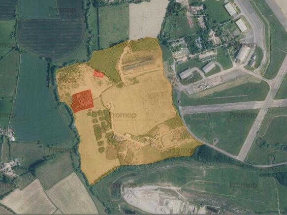
The land comprises former agricultural land that is approximately 112 acres and 45.32 hectares acres. On the site there is long rectangular terrace complex of 3 cow sheds, which have steel portal frames and profile cladding elevations and roofs. Two of the sheds face each other across a central yard area and the third is open to the field to the south. Note the areas shaded red on the indicative aerial view are excluded from the title to be sold.
At the south of the site are several storage units; a terrace of three units, with two units either side of an open central unit, a storage unit with three roller shutter entrances, a storage unit, open on one side, the main storage unit which houses several Biomass boilers, plus an office and staff area and also having three roller shutters and further storage unit with two sliding entrance doors. All units are of portal stell frame construction with profile cladding.
Please Note:
1) It formers part a wider site that has been identified within the South Worcestershire Development Plan Review 2021 - 2041 as having future development potential:
"Throckmorton Airfield (the former RAF Pershore site) and the surrounding areas present the opportunity for a sustainable new settlement incorporating residential and employment uses with supporting physical and community infrastructure. Subject to further work and evidence, Throckmorton could provide a longer-term solution to meeting future housing and employment needs. An approximate Area of Search covering a large area is shown on the Key Diagram (Figure 1) centred on Throckmorton Airfield. Landowners within the Area of Search will be encouraged to engage with the Council in the progression of the proposals for the site prior to the review of the Plan. A future review of the Plan would decide whether a new settlement is deliverable and if it would be a feasible and viable option and, if so, determine a precise location, scale and quantum of land uses required, and any supporting infrastructure."
Interested parties should rely on their own enquiries.
2) The registered owner was convicted of operating an illegal waste site and parts of the whole site are known to have issues of contamination. The Receiver has not commissioned their own survey, but the Environment Agency had previously surveyed the site and initially the owner was prosecuted for six offences where waste totalling around 25,000 cubic metres was either dumped, buried or burned at the site. We understand that the Environment Agency have been monitoring the volume of material on the site and a LIDAR from 2023 suggests a 199,556 cubic meter change in site levels since 2005, equating to a tonnage of 145,378. Subsequent surveys (carried out for third parties, so cannot be disclosed in full) estimate that there is between 216,000 to 267,000 cubic metes on site, including stockpiles of circa 95,000 cubic meters. The waste is understood to be a mixture of screened soli/made ground, mixed shredded waste, shredded wood and mixed construction and demolition waste.
However, the seller cannot confirm and interested parties must rely on their own enquiries and site investigations and a purchaser acknowledges they are responsible for any future clearance, remediation, or other statutory requirements in relation to the site, with their liability commencing on completion of any sale and it is likely the Environment Agency would seek early engagement with the new owners to discuss this.
4) The Land is subject to an overage clause (50% uplift) that runs to 2061 - please refer to the Legal Pack.
Location
Location
The property is situated within a predominantly rural location, that lies approximately 2.75 miles to the north of the market town of Pershore and 0.75 mile north of the village of Pinvin. Worcester city centre is approximately 7.5 miles to the northwest and Evesham 6 miles to the southeast.
Road communications are good, with easy access to the A444 and Junction 7 of the M5 motorway is within 6 miles. Railway stations are available in Pershore and Evesham.
Accommodation
The units at the property has the following approximate gross internal floor areas. Note where access was not possible, we have obtained measurements from Pro-Map OS mapping software.
Cow Sheds: 5500 sq. m (59,202 sq. ft)
Terrace of 3 units: 980 sq. (10,548 sq. ft)
Storage Unit: 320 sq. ft (3,443 sq, ft)
Open sided storage unit: 405 sq. (4,359 sq. ft)
Main Unit with office/staff area: 534 sq. (5,746 sq. ft)
Storage unit: 336 sq. m (3,616 sq. ft)
Tenure
Freehold
Buyer's Administration Fee
There will be a Buyer's Administration Fee of £3,000 (inc VAT) payable upon exchange of contracts.
Additional Information
1. The information contained within the Particulars are given in good faith, but all descriptions, statements, dimensions ( these may have come from a third party source e.g. the seller, valuation reports or historic sales particulars), references to condition and permissions for the use and occupation or other details are made without responsibility and should not be relied upon as representation of fact.
2. If a video walk through, or any other form of virtual tour, is provided whilst every effort is made to accurately give an overview of the property we cannot give any warranty concerning the nature, and condition of the property and the suitability thereof for any and all activities and use. The video, or tour, is provided to assist only and without responsibility and should not be relied upon as representation of fact, or replace all appropriate due diligence a prudent purchaser would make.
3. The property is being sold under Proceeds of Crime legislation. Please see Legal Pack for further details
Brochures
Assisted Bidding FormLegal DocumentsOnline BiddingParcel 2 Land to the South of, Long Lane, Tilesford, Throckmorton, Worcestershire, WR10 2LA

NEAREST STATIONS
Distances are straight line measurements from the centre of the postcode- Pershore Station1.4 miles
- Worcestershire Parkway Station4.7 miles
- Evesham Station5.5 miles
About Landwood Group, Manchester
Lancaster Buildings, 77 Deansgate, Manchester, M3 2BW
Notes
Disclaimer - Property reference 342310. The information displayed about this property comprises a property advertisement. Rightmove.co.uk makes no warranty as to the accuracy or completeness of the advertisement or any linked or associated information, and Rightmove has no control over the content. This property advertisement does not constitute property particulars. The information is provided and maintained by Landwood Group, Manchester. Please contact the selling agent or developer directly to obtain any information which may be available under the terms of The Energy Performance of Buildings (Certificates and Inspections) (England and Wales) Regulations 2007 or the Home Report if in relation to a residential property in Scotland.
Auction Fees: The purchase of this property may include associated fees not listed here, as it is to be sold via auction. To find out more about the fees associated with this property please call Landwood Group, Manchester on 0161 524 9187.
*Guide Price: An indication of a seller's minimum expectation at auction and given as a “Guide Price” or a range of “Guide Prices”. This is not necessarily the figure a property will sell for and is subject to change prior to the auction.
Reserve Price: Each auction property will be subject to a “Reserve Price” below which the property cannot be sold at auction. Normally the “Reserve Price” will be set within the range of “Guide Prices” or no more than 10% above a single “Guide Price.”
Map data ©OpenStreetMap contributors.