
Ardley, Bicester
- PROPERTY TYPE
Land
- SIZE
293,159 sq ft
27,235 sq m
Key features
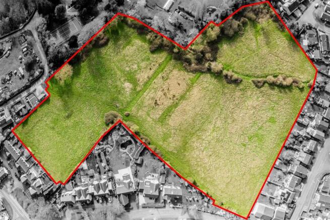
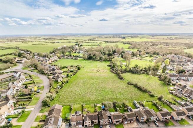
- Land extending to approximately 6.73 acres.
- Accessed via Ardley Road.
- Freehold with vacant possession upon completion.
- Potential development and alternative uses subject to obtaining the necessary planning permissions.
Description
Extending to approximately 6.73 acres (2.72 hectares).
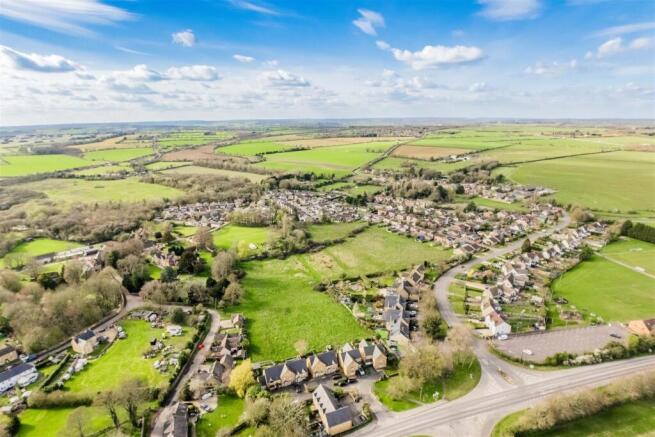
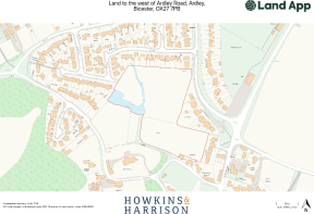
Location - The land is situated respectively between the Oxfordshire villages of Ardley and Fewcott, and benefits from three separate access points from the public highway. Both Ardley and Fewcott provide a basic range of local amenities, with the market town of Bicester (4 miles southeast) offering a wide variety of everyday services, amenities, and employment opportunities.
The land benefits from excellent road links with the A43 and B4100 in immediate proximity, and Junction 10 of the M40 situated approximately 1 mile northeast. Bicester and Milton Keynes provide access to mainline railway services running to London Euston, London Marylebone and Birmingham New Street.
The location is shown on the plan.
Description - The land is a single enclosure of permanent pasture extending to 6.73 acres (2.72 hectares) or thereabouts and benefits from three access points off of the public highway: Somerton Road, Ardley Road and Orchard Road. The land benefits from a mixture of post and wire stock fencing and mature hedgerow and tree boundaries throughout. The property is relatively level, with a well situated within the property. It is understood that the land is designated within the Cherwell Conservation Area.
According to Natural England, the land is classified as Grade 3 on the Agricultural Land Classification maps, being free draining lime-rich loamy soils with moderate fertility.
The land is being marketed as agricultural but could be suited to equestrian use or alternative uses subject to obtaining the necessary planning consents.
Services - It is understood that the property does not benefit from any services. There is a well located in the property which has historically been used to pump water to supply the land.
Purchasers should make their own enquiries regarding the location of the mains service supplies. The cost of providing such services to the site will be at the purchaser’s own expense.
Tenure & Possession - The land is being sold Freehold from Title Number ON289027. The intention is to exchange and complete as soon as practically possible. Vacant possession will be given upon completion.
Easements, Wayleaves & Rights Of Way - The property can be accessed via three separate access points: one from Orchard Road, one from Ardley Road and one from Somerton Road, with a gateway providing access into the land.
There are several public rights of way crossing the property from south to north.
The land is sold subject to and with the benefit of all easements, wayleaves and rights of way that may exist at the time of the sale whether disclosed or not.
Sporting & Mineral Rights - Where Sporting and Mineral Rights are owned, they will be included in the sale.
Overage Clause - The property will be sold with an overage clause to reserve 30% of any uplift in value attributed to each and every change of use or planning permission for a period of 30 years on the land. For the avoidance of doubt, the overage will not be triggered by any agricultural, equestrian or forestry use. Full details will be provided within the legal documentation.
Method Of Sale - The property will be offered for sale by private treaty and interested parties should submit their offers to the agent’s Towcester office.
The vendors reserve the right to offer the property for sale in any order other than that described in these particulars, to sub-divide, amalgamate or withdraw the property from the sale without prior notice.
Local Authorities - Cherwell District Council:
Western Power Tel:
Anglian Water Tel:
Viewing - Viewing is unaccompanied by prior notification and only during daylight hours within reasonable times, with a copy of the brochure to hand.
Neither the vendor or the selling agent is responsible for the safety of those viewing the property and persons taking access do so entirely at their own risk. Please inform Howkins & Harrison of timings for proposed visits through the agent’s Towcester office on , or email tayla.
What3words - ///files.mammoths.bunk
Anti Money Laundering Regulations - Under the Money Laundering Directive (S12017/692) we are required to take full identification (e.g. photo ID and recent utility bill as proof of address) from a potential buyer before accepting an offer on the property. Please be aware of this and have the information available.
Plan, Area & Description - The plan is for identification purposes only.
The plan, area and description are believed to be correct in every way, but no claim will be entertained by the vendor or the agents in respect of any error, omissions or misdescriptions.
Amc - If you would like to discuss financing a purchase of agricultural land, please speak to one of our Agricultural Mortgage Corporation, AMC Agents (Tayla Cave or Andrew Pinny) who will be happy to discuss this with you and make an introduction to AMC on your behalf.
Brochures
Ardley, BicesterBrochureArdley, Bicester

NEAREST STATIONS
Distances are straight line measurements from the centre of the postcode- Bicester North Station3.8 miles
- Heyford Station4.1 miles
- Bicester Town Station4.4 miles

Notes
Disclaimer - Property reference 34616862. The information displayed about this property comprises a property advertisement. Rightmove.co.uk makes no warranty as to the accuracy or completeness of the advertisement or any linked or associated information, and Rightmove has no control over the content. This property advertisement does not constitute property particulars. The information is provided and maintained by Howkins & Harrison LLP, Towcester. Please contact the selling agent or developer directly to obtain any information which may be available under the terms of The Energy Performance of Buildings (Certificates and Inspections) (England and Wales) Regulations 2007 or the Home Report if in relation to a residential property in Scotland.
Map data ©OpenStreetMap contributors.