

Chulmleigh
- PROPERTY TYPE
Land
- SIZE
4,727,567 sq ft
439,206 sq m
Key features
- Productive Farm Land
- 108.53 Acres (43.92 Hectares)
- Direct Road Access
- Available as a Whole and in Two Lots
- LOT 1 - 105.66 Acres with Modern Agricultural Buildings
- LOT 2 - 2.87 Acres with a Stone Quarry
- FREEHOLD
Description
Situation - The land lies approximately 1.9 miles to the north-east of Chawleigh on the border between North Devon and Mid Devon. The town of Chulmleigh lies 3 miles to the west, near to which is the A377 which links Barnstaple and Exeter.
The market town of South Molton is 11 miles to the north and provides a weekly livestock market (prime sheep) and Crediton is 14 miles to the south.
Introduction - The land comprises two modern farm buildings and a commercial sized block of grass land which has been used for silage production and grazing. The land lies at between 100 and 185 metres above sea level with stunning views over the surrounding rolling countryside towards the Dartmoor National Park.
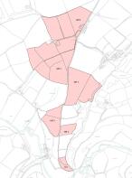
The soils are described as slowly permeable seasonally wet acid loamy and clayey soils with part freely draining acid loamy soils over rock. The land classification is 3 and 4 and the land is available as a whole and in two lots.
Lot 1 - Guide Price £975,000 - LOT 1 totals 105.66 acres (42.76 hectares) and includes the modern farm buildings and the majority of the farm land which lies within five blocks all with direct access to the public highway.
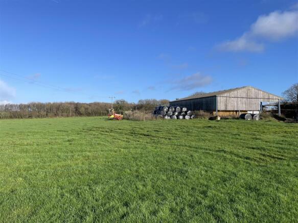
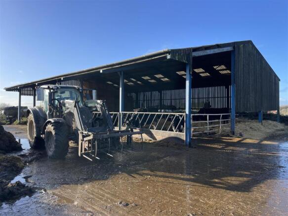
The buildings lie towards the north of the holding with a concrete yard to the front and may have potential for alternative uses (subject to planning consent being obtained).
OPEN FRONTED COW SHED (18.21m x 9.08m). A 4-bay building with a steel portal frame, part timber boarding and park space boarded elevations with a concrete floor, underneath a corrugated asbestos sheeted roof.
OPEN FRONTED LIVESTOCK BUILDING (22.77m x 14.31m). A 5-bay building with a concrete floor, part space boarded elevations underneath a corrugated fibre cement roof.
Immediately adjoining the buildings are three level and gently sloping fields which total 26.81 acres and have a north-facing aspect.
South of this block and on the western side of the road are four fields which total 40.29 acres and have been used to grow a mixture of grass and kale with cow tracks leading from the road through the land. This block has a south-west facing aspect.
On the eastern side of the road are two fields which run down to a stream on the eastern boundary. This block totals 24.32 acres with the roadside field suitable for growing cereal crops and the field running down to the stream suitable for grazing.
The next block south totals 10.40 acres and comprises a single field with a west-facing aspect and extensive road frontage.
The final area of land within LOT 1 is a single field totalling 3.84 acres, which has a south-facing aspect and road frontage on the western boundary.
Lot 2 - Guide Price £30,000 - LOT 2 totals 2.87 acres (1.16 hectares) and comprises an appealing mixture of deciduous woodland, a meadow adjoining a stream and a stone quarry. This lot is secluded and sheltered with road frontage along the western boundary and an existing access gate on to the public highway.
Services - Mains electricity is available nearby. Some of the land is currently served by a borehole which is located on neighbouring land. This water supply will not be continued after completion but we are informed that mains water is available nearby.
Tenure - The land is owned freehold and is registered on the Land Registry.
Method Of Sale - The land is offered for sale by private treaty and is available as a whole and in two lots.
Overage (Development Uplift) - An overage (development uplift) provision will be imposed on the existing farm buildings. Please contact the agents for further information.
Designations & Land Management - The land is within a Nitrate Vulnerable Zone (NVZ) and is currently managed under a Countryside Stewardship agreement (Mid Tier).
Local Authority - North Devon District Council and Mid Devon District Council.
Sporting And Mineral Rights - The sporting and mineral rights insofar as they are owned are included with the freehold.
Wayleaves & Rights Of Way - The property is sold subject to and with the benefit of any wayleave agreement and any public or private rights of way that may affect it.
There are no public rights of way passing through the land.
Viewing - Viewings are strictly by prior appointment with Stags. Please call or email: to arrange an appointment.
Directions - From South Molton, head south on the B3137 and continue for approximately 7.3 miles. At Gidley Cross, turn right and follow this road for 3.5 miles. When you reach Stone Moor Cross turn left. The buildings within LOT 1 will be found on the right after 0.35 miles.
For LOT 2, continue on this road for1.25 miles and the entrance gate will be found on the left.
What3words - LOT 1 - unzipped.massaging.stages
LOT 2 - dynamics.socks.sometime
Disclaimer - These particulars are a guide only and are not to be relied upon for any purpose.
Brochures
ChulmleighChulmleigh

NEAREST STATIONS
Distances are straight line measurements from the centre of the postcode- Eggesford Station3.3 miles
- Lapford Station3.8 miles
- King's Nympton Station4.4 miles


Notes
Disclaimer - Property reference 34379552. The information displayed about this property comprises a property advertisement. Rightmove.co.uk makes no warranty as to the accuracy or completeness of the advertisement or any linked or associated information, and Rightmove has no control over the content. This property advertisement does not constitute property particulars. The information is provided and maintained by Stags, Exeter. Please contact the selling agent or developer directly to obtain any information which may be available under the terms of The Energy Performance of Buildings (Certificates and Inspections) (England and Wales) Regulations 2007 or the Home Report if in relation to a residential property in Scotland.
Map data ©OpenStreetMap contributors.