
Droitwich, Worcestershire
- PROPERTY TYPE
Land
- SIZE
2,065,180 sq ft
191,862 sq m
Key features
- A versatile block of arable land
- In the popular village of Salwarpe
- River frontage
- Biodiversity Net Gain opportunities
- Excellent amenity potential
- For sale by Private Treaty
- In all about 47.41 acres (19.18 ha)
Description
Description
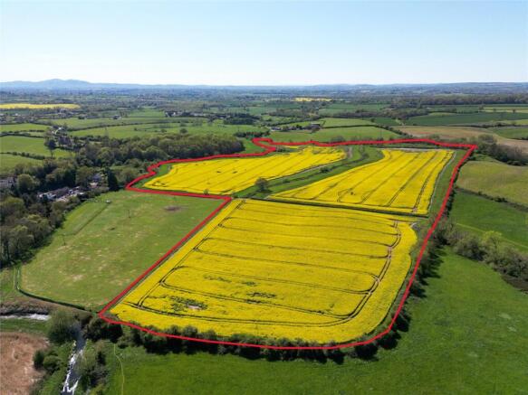
Extending to approximately 47.41 acres (19.18 hectares) the land accessed from Copcut Lane via a bridge over the River Salwarpe. The land is split into three good sized parcels and is bounded by mature hedgerows and trees.
The land is currently cropped with OSR, having been planted with spring barley in the previous growing season. The southern boundary is defined by the River Salwarpe, while the western boundary is formed by the Hadley Brook.
Whilst well suited for agriculture, the land also offers environmental, amenity and lifestyle opportunities.
Situation
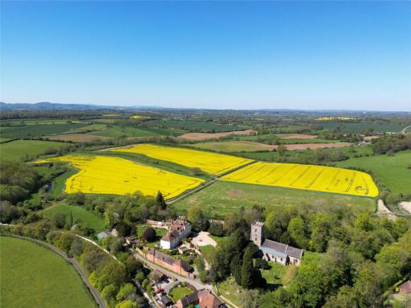
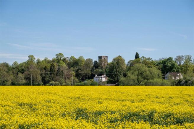
The land is situated in the popular village of Salwarpe near Droitwich Spa in Worcestershire. The area is well connected with easy access to the A38, Worcester Road.
Salwarpe sits on the River Salwarpe and Droitwich Canal and is situated within attractive countryside creating a peaceful rural setting.
Land quality and soil type
The land is classified as Grade 3 according to the Natural England Regional Agricultural Land Classification Maps. The soil is described as slightly acid loamy and clayey soils.
Services
The purchaser is responsible for establishing the cost for the connection of the appropriate services/utilities to the
property. We believe mains water is connected.
Tenure and possession
The land is sold freehold and vacant possession will be available on completion subject to holdover. The Property is registered with the Land Registry under part of title number WR91607.
Holdover
The land will be sold subject to a holdover agreement for the vendor in respect of growing crop until the earlier of completion of the harvest and 31/08/2026.
Method of sale
The property is offered for sale by Private Treaty method. However, the vendor reserves the right to conclude the sale by an alternative method if required.
Sporting timber and mineral rights
The sporting, mineral and timber rights will be transferred with the freehold title where owned.
Local Authority
Wychavon District Council.
Designations
The Property lies within a Surface Water Nitrate Vulnerable Zone (NVZ) Area and is subject to the usual restrictions.
The southernmost parcel of land is situated within Floodzone 3.
A spinney of Oak Trees in the northwest corner are covered by a Tree Protection Order. Ref: TPO/W/75/57/001/TPO
Public rights of way, wayleaves and easements
The Property is sold subject to and with the benefit of all easements, quasi easements, wayleaves and rights of way both declared and undeclared.
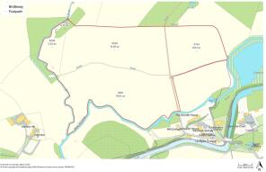
We are aware that there is a bridleway and a public footpath crossing the property.
There is a Severn Trent Water foul sewer main which crosses under the land and there are three raised manhole covers on the property two of which are within the field margins.
There is a National Grid Transmission tower within an area of set aside to the west of the property and the land is also crossed by National Grid Distribution 11kV lines.
Environmental Schemes
The land is entered into a Countryside Stewardship (Middle Tier) Agreement which expires 31/12/2026. The options entered are watercourse buffer strips on cultivated land and management of hedgerows. The purchaser will be required to meet the aims of these objectives and indemnify against any breaches until the expiration of the scheme.
The vendor is part way through a England Woodland Creation Offer (EWCO), the details of which can be shared with a purchaser.
A Biodiversity Net Gain (BNG) baseline survey was conducted on 16th September 2024 to identify potential commercial returns for delivering biodiversity offset units, a copy of this report can be made available on request.
Planning
The selling agents will not provide advice/guidance on the planning history for the property/land. Interested parties are advised to make their own investigations. It is assumed that enquiries have been satisfied, prior to an offer being made.
Anti Money Laundering Regulations (AML)
In accordance with Anti Money Laundering Regulations (AML), we are required to request forms of identification and carry out due diligence on any parties connected to a successful offer. Should an offer be made on behalf of a business/company, AML due diligence will also be necessary. Proof/source of funding must be supplied, prior to offer acceptance.
Plans and boundaries
The plans within these particulars are based on Ordnance Survey data and provided for reference only. They are believed to be correct but accuracy is not guaranteed. The purchaser shall be deemed to have full knowledge of all boundaries and the extent of ownership. Neither the vendor nor the vendor’s agents will be responsible for defining the boundaries or the ownership thereof.
Viewings
Strictly by appointment through Fisher German LLP. On foot at any reasonable time during daylight hours, with a copy of these particulars in hand.
Directions
Postcode – WR9 0AH
what3words – ///branded.nicely.tastier
Brochures
ParticularsDroitwich, Worcestershire

NEAREST STATIONS
Distances are straight line measurements from the centre of the postcode- Droitwich Spa Station1.4 miles
- Worcester Shrub Hill Station4.4 miles
- Worcester Foregate Street Station4.5 miles


Notes
Disclaimer - Property reference WOR260013. The information displayed about this property comprises a property advertisement. Rightmove.co.uk makes no warranty as to the accuracy or completeness of the advertisement or any linked or associated information, and Rightmove has no control over the content. This property advertisement does not constitute property particulars. The information is provided and maintained by Fisher German, Worcester. Please contact the selling agent or developer directly to obtain any information which may be available under the terms of The Energy Performance of Buildings (Certificates and Inspections) (England and Wales) Regulations 2007 or the Home Report if in relation to a residential property in Scotland.
Map data ©OpenStreetMap contributors.