Commercial Properties For Sale by Bruton Knowles, Birmingham
3 results
Paid partnerships can play a role in listing order
 1/5
1/5
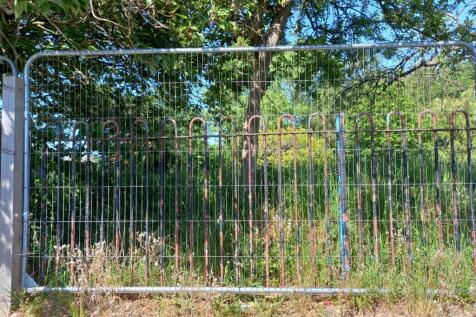
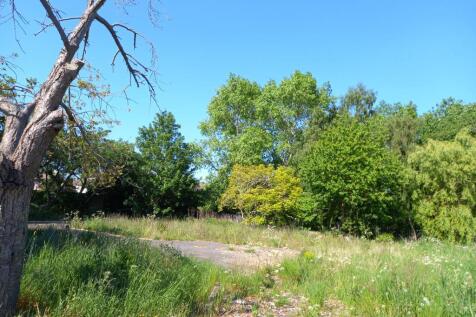
The Property comprises 0.29 of an acre of potential development land on Hillcrest Road in the residential Camp Hill area of Nuneaton. It forms part of Land Registry Title number WK202824, with the land to be disposed of outlined in red on the particulars. The building shown within the red line boundary and on publicly available Satellite imagery has been demolished, and the woodland to the rear of the title is to be excluded. The Property is regular in shape being roughly rectangular comprising scrubland, self-regenerated trees, and tarmacadam and concrete surfacing. This provides an excellent opportunity for potential residential development, with a positive pre-application response from the local planning authority in principle.

- Positive pre-application response for four residential dwellings
- Bare Site - building now demolished
- 0.29 of an acre (0.12 of a hectare)
1/1
The Land comprises an area of grassland bounded by mature trees and hedgerows on three sides, and a wooden post and rail fence to the north. The extent of the Land being sold is defined by the red line boundary on these particulars and extends to approximately 4.13 acres (1.67 hectares). The boundary is for identification purposes only, and its exact position will need to be accurately defined on site as part of the sales process.
1/2

The Land is generally flat and comprises approximately 17.5 acres of arable land bound by mature trees and hedgerows. It is currently accessed from the northwest corner through a single gate off Upper Wick Lane. The Land is included within the Adopted South Worcestershire Development Plan Review (South Worcestershire Development Plan Review 2021 - 2041 - South Worcestershire Development Plan) as a strategic allocation forming part of an 83.29-hectare site at Rushwick (SWDPR 56): Land within the strategic allocation at Rushwick will be developed to deliver approximately 1,000 new dwellings within the Plan period, provide at least 5 hectares of employment land, a new railway station, a new primary school, retail and supporting services and other community facilities. See page 188 of the South Worcestershire Development Plan Review for an indictive concept plan. The Vendor supported the proposed allocation throughout the development of the SWDPR, entering into a Statement of Common Ground on 12 February 2025 stating that it will work with the South Worcestershire Councils and the other landowners on delivering the proposed expansion of Rushwick. Any future landowner is expected to comply with the stated objectives of RES and work with the South Worcestershire Councils and third-party landowners.
- For Sale by Informal Tender
- Allocated Strategic Land
- For Freehold Sale or Promotion Terms
1/5The Property comprises 0.29 of an acre of potential development land on Hillcrest Road in the residential Camp Hill area of Nuneaton. It forms part of Land Registry Title number WK202824, with the land to be disposed of outlined in red on the particulars. The building shown within the red line boundary and on publicly available Satellite imagery has been demolished, and the woodland to the rear of the title is to be excluded. The Property is regular in shape being roughly rectangular comprising scrubland, self-regenerated trees, and tarmacadam and concrete surfacing. This provides an excellent opportunity for potential residential development, with a positive pre-application response from the local planning authority in principle.
1/1The Land comprises an area of grassland bounded by mature trees and hedgerows on three sides, and a wooden post and rail fence to the north. The extent of the Land being sold is defined by the red line boundary on these particulars and extends to approximately 4.13 acres (1.67 hectares). The boundary is for identification purposes only, and its exact position will need to be accurately defined on site as part of the sales process.
1/2The Land is generally flat and comprises approximately 17.5 acres of arable land bound by mature trees and hedgerows. It is currently accessed from the northwest corner through a single gate off Upper Wick Lane. The Land is included within the Adopted South Worcestershire Development Plan Review (South Worcestershire Development Plan Review 2021 - 2041 - South Worcestershire Development Plan) as a strategic allocation forming part of an 83.29-hectare site at Rushwick (SWDPR 56): Land within the strategic allocation at Rushwick will be developed to deliver approximately 1,000 new dwellings within the Plan period, provide at least 5 hectares of employment land, a new railway station, a new primary school, retail and supporting services and other community facilities. See page 188 of the South Worcestershire Development Plan Review for an indictive concept plan. The Vendor supported the proposed allocation throughout the development of the SWDPR, entering into a Statement of Common Ground on 12 February 2025 stating that it will work with the South Worcestershire Councils and the other landowners on delivering the proposed expansion of Rushwick. Any future landowner is expected to comply with the stated objectives of RES and work with the South Worcestershire Councils and third-party landowners.
