Commercial Properties For Sale by Bruton Knowles, Gloucester, including sold STC
76 results
Paid partnerships can play a role in listing order
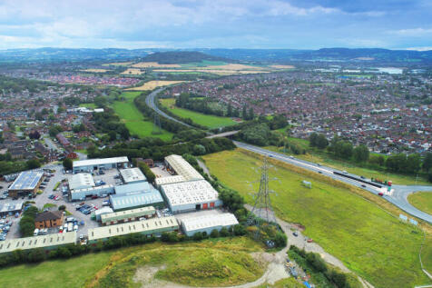
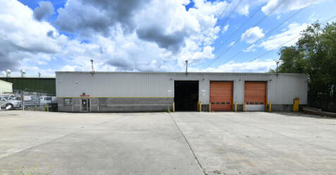
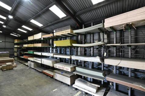
This self contained site on Innsworth Technology Park was established as a Royal Mail distribution depot but more recently has been the main storage and distribution centre for an international sheet materials company. It comprises; a two storey office block with open plan accommodation, two large yards (each with individual access) and a number of warehouses and storage sheds. The main warehouse has an internal office and facilities block, and office sales counter facing yard 2. There is scope for each yard to be operated independently either for renewed owner-occupation or multi-let occupancy, and there is potential to develop or re-develop the site subject to consents. Local amenities include the Park Diner which is less than two minutes walk from the office building.

 1/1
1/1
The site extends to approximately 157.58 acres (63.77 hectares) and comprises arable land which slopes away from the A451 before becoming slightly undulating as the site meets Hurcott Wood to the south. The land edged in blue on the front page is to be excluded from any agreement and a right of way will be retained for access. The site comprises the whole of Freehold Title WR151828 and the majority of Freehold Title WR151855. The freeholds are in separate ownership. Immediately to the north of the A451 is an evolving new village, referred to as 'Lea Castle Village'. The site benefits from an existing Reserved Matters permission for 600 no. homes and is well under construction. The wider site has an outstanding outline application pending for a further 800 no. homes which surrounds the existing 600 no. homes and extends south to the A451, beyond which is the subject site. The site is available for promotion via an Option or Promotion agreement and parties are invited to submit terms including as follows: Type of agreement Percentage - discount/share of proceeds Premium payment (s) to landowners Term (s) of agreement/Longstop Any deductible costs and cost caps Minimum price per gross acre Planning strategy Confirmation of payment of landowners' professional fees (including agent & legal) Offers should be received to Bruton Knowles via email to Harry Breakwell.
1/6


A rare opportunity to buy an attractive block of permanent grassland which adjoins the thriving market town of Stroud. Location The land at Ruscombe and Humphreys End is located to the north of Stroud and is on the northern edge of Cashes Green and Archway School. The block of land is separated by Ruscombe Road which provides access to both the eastern and western parcels. Description Lot 2 - 13.96 acres (5.65 ha) A single enclosure of permanent pasture on a south west facing slope with direct road access off Ruscombe Road bounded by mature hedges and stock fencing. Overage The land is being sold subject to an overage clause for a period of 30 years at the rate of 30% of the uplift in value if planning permission is granted for either commercial or residential development. For the avoidance of doubt the erection of the farm buildings, stables or dwellings subject to Agricultural Occupancy Conditions will not trigger an overage payment.
1/3


The site extends to a total of 4.64 acres (1.88 ha) of agricultural land located immediately east of the ribbon housing along Badsey Fields Lane on the eastern edge of Badsey. The parcel is predominantly flat and currently presents as open grassland bordered by low hedgerows, with no built structures on the land itself. The site is bordered by open arable fields to the east and south, while detached and semi-detached dwellings front Badsey Fields Lane to the west. The site is offered in Lots which includes c.2.45 acres immediately accessed off Badsey Fields Lane to the north (Lot A) and the remaining land which is shaded blue on the front page. Offers for part and the whole will be considered, with exact boundaries to be confirmed.
- LOT A - Permission in Principle for up to 9 no. units
- LOT B - Additional strategic land available
- Total plot area of 4.64 Acres
1/6


3.43 acres of pasture land with traditional buildings, ideal for conversion into stabling with yard area to the front. The property is well located with extensive hacking on Minchinhampton Common in close proximity. For sale by Informal Tender. Offers to be received via email to eleanor. by noon on Tuesday 14th January 2025. Viewings by appointment only.
 |1/9
|1/9


The site is in active use as an HGV storage and distribution facility and includes a range of industrial buildings, large-scale greenhouses and polytunnels, providing a mixture of hardstanding and developed areas. The scale of the site and its existing commercial B8 use, indicates that there is good scope for industrial redevelopment, subject to obtaining the necessary planning consents. The site may be suitable for the construction of new-build industrial or logistics buildings, with potential for reconfiguration or comprehensive redevelopment to meet modern occupier requirements. The site's size, good access and layout offers flexibility for a plethora of industrial uses including warehousing, storage, distribution or ancillary employment uses, subject to planning. Its established commercial character and current operational use further underpin its potential for future industrial-led development.
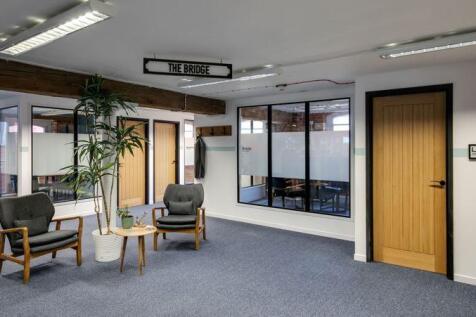
1/16This self contained site on Innsworth Technology Park was established as a Royal Mail distribution depot but more recently has been the main storage and distribution centre for an international sheet materials company. It comprises; a two storey office block with open plan accommodation, two large yards (each with individual access) and a number of warehouses and storage sheds. The main warehouse has an internal office and facilities block, and office sales counter facing yard 2. There is scope for each yard to be operated independently either for renewed owner-occupation or multi-let occupancy, and there is potential to develop or re-develop the site subject to consents. Local amenities include the Park Diner which is less than two minutes walk from the office building.
1/5


The Property is located to the rear of INEOS Aycliffe Business Park, formerly owned by Hydro Polymers, which sold the site to INEOS Newton Aycliffe Limited in 2008. The other site occupiers are Inovyn Newton Aycliffe Limited (formerly known as Norsk Hydro Polymers Limited) and INEOS Enterprises Compounds Ltd, which jointly occupy roughly four-fifths of the site. The estate is contained within a high-security ring fence, with gated secure access from School Aycliffe Lane. Access to the Property is via the manned, high-security entrance, leading onto a well-maintained Business Park with estate roads and an open layout, with plenty of green space between buildings, reflecting its origins as an MoD munitions factory and depot. All in all, it presents well and comprises a modern production facility incorporating production areas, laboratories, offices, stores, tank farms and all of the supporting infrastructure, such substations, pump rooms and interceptors. The subject Property comprises a modernised manufacturing facility, three storage buildings, a covered loading bay, a tank farm, hardstanding areas and internal roads, occupying a total site area of approximately 11 acres. Building H Building H, the main manufacturing facility, is a purpose-built industrial building comprising three steel portal-framed interconnection buildings providing a gross internal area of approximately 80,000 sq ft, with an eaves height of circa 10 metres. This building was substantially...
1/6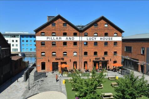
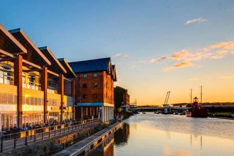
£290k Base Rent. Pillar & Lucy House is a Grade II listed warehouse built in 1835 on the east bank of the Gloucester Sharpness Canal for sugar importers Messrs Phillpotts and Baker. Gloucester Docks, originally constructed in the early 19th century to support the city's expanding trade, have since been revitalised into a lively cultural hub. The upper floors, supported on a colonnade of cast-iron pillars, extended over the quay to provide temporary covered storage. From 1850 the building was occupied by corn merchants - initially J & C Sturge, followed by W C Lucy & Co in the 1860s and Smith & Cornock from the 1890s. In 1917 the building interior was damaged by fire. Gloucester City Council granted planning permission in 1983 to convert Pillar & Lucy House to offices, a pub, wine bar and restaurant. The covered quayside was a huge asset when the ground floor opened as a pub The Waterfront in 1984. Two years later it had become live music and real ale venue The City Barge. Following extensive refurbishment of the entire building, the very popular Coal Kitchen bar and grill opened in 2007
|1/19


On behalf of Gloucester City Council we are offering these imposing and substantial properties that comprise the former headquarters for the City Council known as Herbert, Kimberley and Phillpotts Warehouses (HKP). Within Kimberley Warehouse the public house known as Doctor Foster's continues to trade and is unaffected by the disposal of these buildings. In addition the 2 floors at the same level as Doctors Fosters in Phillpotts Warehouse are also excluded from the sale. These exceptional properties provide a rare opportunity for a developer or owner occupier to give these buildings a new lease of life through a sympathetic refurbishment for a range of potential uses that complement the thriving commercial and residential community at this waterside location. Herbert, Kimberley and Phillpotts date back from 1846 and were built originally to accommodate the growth of Gloucester Docks during the Victorian era. They were named after the corn merchants that constructed them and stand as an iconic testament to the entrepreneurial spirit that Gloucester has always enjoyed. The buildings were restored and converted to offices by Gloucester City Council in 1985 to include glazed linked walkways between each block. Each building enjoys a Grade II listing status is of solid brick construction over 6 floors (with a basement) with timber truss roofs covered with natural slate. Gloucester Docks has seen major investment with the majority of the other warehouses converted to...
1/20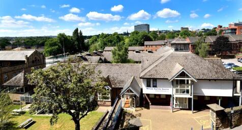


- The Site is in the Devonshire Quarter which has been identified as an area for the 'Expansion of City Centre Living' which establishes the principle of residential development - Purpose Built Student Accommodation. Policy CS4a is fairly flexible in allowing PBSA and direct PBSA, specifically in this quarter of the city - Preferred Use Classes are C2 and C3 - Acceptable uses include; HMOs and classes, E, F1 and F2 The Wilson Carlile Centre was purpose-built in 1992 by the Church Army as a modern, welcoming base for mission, hospitality and training. Its thoughtful layout - combining open plan offices, café, chapel and en-suite accommodation - makes it highly adaptable for today's needs. And with no listing or planning constraints, it offers the flexibility to re-imagine its future. The Wilson Carlile Centre comprises three buildings: the main Centre and two adjoining residential blocks, all arranged around an attractive landscaped grounds. The versatile main building offers: - Reception, café with commercial kitchen, and open-plan offices - Flexible meeting and conference rooms with sliding partitions - Seminar rooms, library, chapel, and well-appointed WCs - Basement storage with gym-ready facilities, including showers and changing rooms Constructed of brick and block with part-rendered elevations, the Centre features exposed brickwork, timber beams, carpeted concrete floors, and a mix of LED and fluorescent lighting. Heating is provided by gas-fired central
 |1/19
|1/19


A rare opportunity to acquire a ringfenced block of arable and pasture land together with a range of agricultural buildings in west Gloucestershire. Approximately 218.05 acres (88.24 ha) in total. For sale as a whole or in two lots. Lot 1-Farm buildings, arable and pastureland extending to 125.86 acres (50.93 ha) - Guide Price £1,275,000. Lot 2-Pasture land and range of traditional stone barns extending to 92.19 acres (37.31 ha) - Guide price £725,000. Guide Price for the whole £2,000,000 Situation Hoarthorns Farm is situated 2 miles north east of Coleford in the Forest of Dean. The village of Edge End lies on the A4136 linking from the A40 at Huntley through to Monmouth. Ross-on-Wye lies close just 9 miles north providing easy access to the M50 motorway. Lot 1- Farm buildings, arable and pasture land extending to 125.86 acres (50.93 ha) Lot 1 extends to approximately 125.86 acres (50.93 ha) and comprises a block of Grade 2, 3 and 4 arable land, permanent pasture, a small block of traditional Woodland, and farm buildings, edged red on the sale plan. The land lies to the north of Edge End and is accessed via a good gated track leading off a council maintained road accessed directly off the A4136. To the south east of Lot 1 is a farmyard and a range of farm buildings with the two steel framed
1/13


The unit is of modern construction providing self-contained office accommodation on both ground and first floor levels. The unit further benefits from a large ground floor workshop alongside large external yard space currently used for parking. The unit and site itself have been very well maintained and provide a good mix of single offices, open plan workspace, meeting and board rooms and large open plan workshop accessible via passenger and roller shutter door.
1/6


The site itself extends to approximately 1.07 acres (0.43 ha) and comprises a tarmac car park which slopes downwards from the west of the site through to the east. There is also a small set of garages and two boarded-up commercial premises on the site, with a number of overgrown trees/shrubs which are dotted throughout. Existing access to the site can be gained through an off-road from Worcester Road which borders the site's western edge, and off Edith Walk which borders the south of the site. Directly west of the site is the Foley Arms Hotel, Nation Wide Bank and Barclays Bank. Bordering the site's western boundary is Waitrose & Partners and bordering its northern boundary are private gardens associated with the buildings along Worcester Road.
|1/8


Birdwood House Farm is a Grade II listed farmhouse, laid out over three storeys with a lawn garden to the front and an enclosed courtyard to the rear. The property also benefits from a full-length cellar with potential to be converted. The farm buildings extend beyond the house and comprise of a Grade II listed red brick workshop with hayloft above and adjoining former dairy, 4 steel portal framed buildings with further timber barn and five concrete block loose boxes with concrete yard surrounding. The accommodation briefly comprises: full length entrance hall and porch, kitchen, dining room, living room, utility with an external door and adjoining bathroom including shower, WC and basin, full length cellar, master bedroom with walk in wardrobes, four further double bedrooms (some with built in wardrobes), an attic room with restricted head height but potential to be an additional bedroom, office and family bathroom comprising of a shower over the bath, bidet, basin and WC. There is a built-in airing cupboard in the bathroom and stairway to a currently disused yet boarded out attic room. The Grade 3 land is mainly located to the rear of the farm buildings. In total it extends to approximately 37.39 acres of arable and pasture land. The land is predominately Grade 3 land and lies over slightly acidic loamy and clayey soils with impeded drainage. The land also falls within a Nitrate Vulnerable Zone (NVZ). There is a public footpath running along the northern boundary of...
1/10


Approximately 93.66 acres of predominantly arable land, with one pasture field and some small areas of mixed native amenity woodland. The land is for sale as a whole or in two lots. The Land is situated in an attractive area of rural Worcestershire approximately 1.8 miles south of the market town of Upton upon Severn. Located immediately south of the rural village of Newbridge Green, the land lies at the junction of the B4211 and Avenue Road. Junction 1 of the M50 motorway is approximately a 10 minute drive away.
|1/4


Bruton Knowles have been formally instructed to market a unique development opportunity to acquire a farmstead with detailed planning permission for 11 dwellings, located within close proximity to the desirable town of Malvern. Newland Court is a farmstead within the parish of Newland, around 0.7 miles northeast of Malvern Town, 3 miles from Great Malvern town centre and 6.5 miles from Worcester City Centre. The site is accessed directly from the A449 Worcester Road, which runs along its frontage. The location is particularly well located for easy access to motorway and other transport links in particular the A449, A4103 and the M5 motorway. The subject site relates to a farmstead comprising a Grade II Listed Georgian Farmhouse and farmyard. The Farmhouse is set back from the road with a large garden and a private vehicular entrance and driveway. A further access point is located along the A449, providing sperate access to the farmyard. The farmyard comprises a range of traditional brick build barns. Guide Price of offers in excess of £1,100,000.
|1/8


Birdwood House Farm is a Grade II listed farmhouse, laid out over three storeys with a lawn garden to the front and an enclosed courtyard to the rear. The property also benefits from a full-length cellar with potential to be converted. The farm buildings extend beyond the house and comprise of a Grade II listed red brick workshop with hayloft above and adjoining former dairy, 4 steel portal framed buildings with further timber barn and five concrete block loose boxes with concrete yard surrounding. The accommodation briefly comprises: full length entrance hall and porch, kitchen, dining room, living room, utility with an external door and adjoining bathroom including shower, WC and basin, full length cellar, master bedroom with walk in wardrobes, four further double bedrooms (some with built in wardrobes), an attic room with restricted head height but potential to be an additional bedroom, office and family bathroom comprising of a shower over the bath, bidet, basin and WC. There is a built-in airing cupboard in the bathroom and stairway to a currently disused yet boarded out attic room. The Grade 3 land is mainly located to the rear of the farm buildings. In total it extends to approximately 16.51 acres of pastureland. The land is predominately Grade 3 land and lies over slightly acidic loamy and clayey soils with impeded drainage. The land also falls within a Nitrate Vulnerable Zone (NVZ). There is a public footpath running along the northern boundary of the main...
|1/10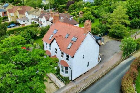
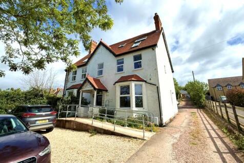
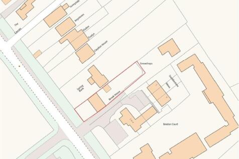
Brook House is a period property located off Station Road, directly opposite New Barn Close Surgery and adjacent to a residential development currently under construction, which will provide approximately 113 new homes. Formerly operating as an 8-bedroom guest house (Class C1), the property was subject to a change of use application approved in 2022. It has since been converted into a clinic and therapy practice with associated office accommodation (Class E (e)). The building is arranged over three storeys and extends to approximately 2,466 sqft (as stated in the Residential EPC). At ground floor level, the property comprises a spacious entrance hall, a large front-facing lounge and dining room with bay windows, a dual-aspect kitchen fitted with modern worktops and cabinetry, a WC, and a doctor's room to the rear with direct access to the garden. The first floor provides two large administrative offices, three therapy rooms, and a bathroom located off the landing to the rear. The second floor consists of a converted loft space, currently arranged as two storerooms, a staff rest room, and a bathroom. Externally, the front of the property offers a gravel parking area, including two EV charging points, along with a ramped pathway leading to the main entrance. To the side, a shared driveway provides access to the rear garden, additional parking, and a garage. This driveway is owned by the neighbouring residential property known as "Snowdrops"
|1/9


An opportunity to acquire a useful block of farmland set in a convenient accessible location between Cheltenham and Bishop's Cleeve. In all about 72.48 acres. The land is situated on the edge of Southam, just to the north of Cheltenham in an accessible yet semi-rural position. Access is taken directly via Ratcliff Lawns, providing convenient entry from the local road network. The land lies approximately 3 miles north of Cheltenham town centre, with the nearby villages of Southam and Prestbury both within easy reach. The A435 is close by, offering direct links to Cheltenham, Bishops Cleeve and onwards to the M5. Description The land lies within a ring-fenced block and is accessed via a field gate at the end of Ratcliff Lawns. A section of frontage along New Road offers potential to create an additional access point, subject to the necessary consents. In total, the property extends to approximately 72.48 acres, comprising 70.73 acres of arable land and a 1.75-acre grass paddock situated along the eastern boundary adjoining New Road. The land is classified as Grade 3 on the Provisional Agricultural Land Classification maps and has proven to be a versatile and productive block, currently sown to maize for the 2026 season. Planning Use The property is situated within the Local Authority of Tewkesbury Borough Council and is designated as agricultural land. Tenure Freehold with Vacant Possession. VAT The property is not elected for VAT. Legal Costs Each party is...
|1/6


Approximately 74 acres of productive river meadow and pastureland, divided into several well-defined enclosures, with three fields benefiting from direct access onto the B4213 and extensive frontage to the River Severn. The land is offered for sale as a whole or in two lots, as shown in these particulars. Alternative lotting arrangements will be considered, subject to agreement. Location The land lies to the south-west of the popular village of Apperley, adjoining the B4213. Apperley is a well-served and attractive village offering a primary school, two public houses, a tennis court and cricket club, together with sailing and fishing opportunities on the nearby Rivers Severn and Avon. The land occupies a convenient and accessible location, benefiting from direct roadside access and being within easy reach of the surrounding villages of Coombe Hill, Deerhurst, Tirley and Hasfield. Description The land extends to approximately 74 acres of productive river meadow and permanent pasture, divided into five well-proportioned enclosures. There are three points of direct access from the B4213, which runs parallel with the southern boundary. The remaining enclosures are readily accessible internally via the adjoining fields, providing good access throughout the holding. The western boundary follows the meandering River Severn, with the land benefiting from over 1,000 metres of river frontage. Owing to its proximity to the river, the land is susceptible to seasonal flooding...
1/11


Land with Residential Development Potential - Unconditional and Subject to Planning Offers Invited. Please note: It is a condition of the vendors that the existing dwelling house is to be Demolished as part of the sale. The land is considered to have residential development potential and forms part of a large urban extension. Please see the particulars for the planning allocation information. The land extends to approximately 0.72 acres (0.288 hectares). The property benefits from an established C3 - Residential Use. The Local Planning Authority is Tewkesbury Borough Council. An indicative residential development scheme has been drawn up and this feasibility scheme provides for seven residential dwellings. The land is located within an area which has been removed from the Green Belt as part of the adopted Joint Core Strategy and is allocated as a Strategic Allocation and Urban Extension under A4 - North Brockworth. The area will be subject to a CIL Rate of £35 per SQM (subject to indexation). A reduced unit number may be preferred, to reduce affordable housing requirements. A pre-application with the Local Authority was undertaken in 2021 in respect of a previous indicative layout. A copy of which is provided in the information pack. Purchasers are to undertake their own planning due dilligence. Please email william. for a copy of the information pack.
|1/17


The property is arranged over four floors, with basement, ground, first and second floor and provides well-proportioned commercial accommodation with good natural light throughout. Whilst the unit is currently occupied by 'Hands On Wellbeing' as therapy and treatment rooms, the layout is adaptable and lends itself to use as offices, professional services, creative workspace, or alternative commercial uses (subject to any necessary consents). The property benefits from a large external front car park providing space for turning and circa 7 parking spaces. The property (including the building, walls, railings and piers) is Grade II Listed.
1/7


A rare opportunity to buy an attractive block of permanent grassland which adjoins the thriving market town of Stroud. Location The land at Ruscombe and Humphreys End is located to the north of Stroud and is on the northern edge of Cashes Green and Archway School. The block of land is separated by Ruscombe Road which provides access to both the eastern and western parcels. Description Lot 1 - 27.87 acres (11.28 ha) A block of south facing permanent pasture separated into three parcels by mature hedges and fencing. There is access direct from Ruscombe Road with a short track leading down to a pole barn with earth floor and concrete yard area. Lot 2 - 13.96 acres (5.65 ha) A single enclosure of permanent pasture on a south west facing slope with direct road access off Ruscombe Road bounded by mature hedges and stock fencing. Lot 3 - 7.26 acres (2.94 ha) A single enclosure of permanent pasture on a north east facing slope with direct road access off the lane opposite More Hall Convent, bounded by mature hedges and stock fencing. Overage The land is being sold subject to an overage clause for a period of 30 years at the rate of 30% of the uplift in value if planning permission is granted for either commercial or residential development. For the avoidance of doubt, the erection of farm buildings, stables, or dwellings subject to Agricultural Occupancy Conditions will not trigger an overage payment.
1/4


REDEVELOPMENT OPPORTUNITY (STP) - 28 Hempsted Lane, Hempsted, Gloucester, GL2 5JA DESCRIPTION The broadly level site extends to circa 0.39 acres and is currently occupied by light industrial units. Immediately adjoining the site to the west are neighbouring properties 28A & 28B Hempsted Lane which were converted from their original industrial/office uses to create residential dwellings (consented in 2017). The site is bordered to the north by an unnamed road which leads to Hempsted Recycling Centre, Hempsted Lane to the east, existing commercial development to the west. Immediately abutting the site to the south is an area of open space associated with the recently delivered housing redevelopment of the former oil depot. According to the Government's Flood Map for Planning, the site is entirely within Flood Zone 3, although the site is clearly situated in an elevated position and is not known to have flooded. It is envisaged that due to the Flood Zone, a detailed Flood Risk Assessment and Topographical Survey will be required. Existing Accommodation The main part of the site comprises primarily a property of brick and steel construction resting under a pitched roof covered with cladding. The internal height varies between 2.8m and 4m and access is from several roller shutter doors. Attached at the front of the building are several concrete sectional buildings providing additional storage, WCs and kitchen. Dual access is currently provided via Hempsted Lane to the east...
|1/6


Approximately 56 acres of productive river meadow and pastureland, divided into several well-defined enclosures benefiting from direct access onto the B4213 and extensive frontage to the River Severn. The land is offered for sale as a whole or in two lots, as shown in these particulars. Alternative lotting arrangements will be considered, subject to agreement. Location The land lies to the south-west of the popular village of Apperley, adjoining the B4213. Apperley is a well-served and attractive village offering a primary school, two public houses, a tennis court and cricket club, together with sailing and fishing opportunities on the nearby Rivers Severn and Avon. The land occupies a convenient and accessible location, benefiting from direct roadside access and being within easy reach of the surrounding villages of Coombe Hill, Deerhurst, Tirley and Hasfield. Description The land extends to approximately 56 acres of productive river meadow and permanent pasture, divided into three well-proportioned enclosures. There is a point of direct access from the B4213, which runs parallel with the southern boundary. The remaining enclosures are readily accessible internally via the adjoining fields, providing good access throughout the holding. The western boundary follows the meandering River Severn, with the land benefiting from over 1,000 metres of river frontage. Owing to its proximity to the river, the land is susceptible to seasonal flooding. However, it provides...
1/4


Approximately 21.13 acres (8.55 hectares) available as a whole only or in two lots of 9.42 acres and 11.71 acres of pasture land including some woodland and extending to the center of the River Frome. Lot 1 lies outside the Area of Outstanding Natural Beauty There is a proposed overage on both lots for any non equestrian or agricultural use.
1/3


Lot 1 The land comprises of permanent pasture land which is sloping in part. The majority of the land is fenced with post and wire or hedgerows. We understand the land to lie over slightly acid loamy and clayey soils with natural springs and some loamy shallow lime-rich soils over chalk or limestone. There is a public footpath crossing the western parcels. Offers to be recieved by noon on Thursday 30th July 2026
|1/7


Approximately 26.78 acres of agricultural land recently in arable rotation occupying a prime Cotswold location. For sale as a whole by Formal Tender. Tender deadline 15th November 2024. Situation The land lies to the east of the minor county road that links the A40 and A429. The field is situated just 0.2 miles south of Clapton-on-the-Hill and 2.2 miles north of Sherborne. The larger towns and villages of Bourton-on-the-Water, Stow-on-the-Wold, and Burford are all within easy reach. Description The land comprises gently undulating pasture bordered by a mixture of mature hedgerow and trees. The field was last ploughed three years ago and was predominately in arable production up to this date. The land is currently down to grass with a white clover lay drilled when last ploughed. The land presents an opportunity to easily convert the field back to arable or utilise the field for feedstock production or the grazing of livestock or horses. Accessed via a field opening to the south west of the parcel, the land rises gently to the north east with excellent views across to Sherborne and Farmington to the south. Public Rights of Way A Restricted Byway crosses the land, entering off the adjacent road to the north west of the field and extends diagonally across the parcel before existing to the north east. The Byway allows for...
