Stidston Lane, South Brent
- PROPERTY TYPE
Land
- SIZE
174,240 sq ft
16,187 sq m
Description
DIRECTIONS
From South Brent, proceed along the B3372 towards Exeter for approximately 1 mile, then turn left onto Stidston Lane. Proceed along Stidston Lane for approximately 500 yards and as you approach the crossroads, the first entrance gateway (to Lot 1) is located directly ahead. The second entrance gateway (to Lot 2) is a further 150 yards on the right hand side.
What3Words Location – uptown.worlds.takeovers
Grid reference – SX 7119 6057
SITUATION
The land at Stidston Lane is situated approximately 1 mile to the east of South Brent village within the South Hams Area of South Devon as well as Dartmoor National Park.
The nearby city of Plymouth is approximately 17 miles to the southwest while the A38 dual carriageway expressway, connecting to the M5 motorway and national road network, is situated approximately 1 mile to the east with access via Marley Head.
DESCRIPTION
The land at Stidston Lane extends in all to approximately 4.07 acres (1.65 ha) in all. Lot 1 extends to approximately 2.43 acres (0.98 ha) and Lot 2 extends to approximately 1.64 acres (0.66 ha).
The land has been used extensively for agriculture, equestrian, and recreational uses in the past and offers great potential for all such in the future (subject to obtaining the necessary planning consents).
Note The Great Western railway track runs alongside the northern boundary of the land.
The land is offered for sale as a whole or in 2 lots to suit buyers’ requirements. Dealing with each lot in turn:-
LOT 1 (as shaded in yellow)
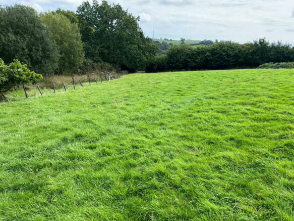
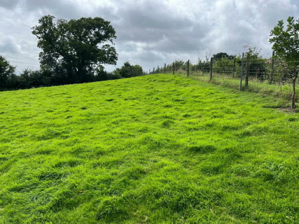
Extending to approximately 2.43 acres (0.98 ha) of primarily permanent pasture with an area of reeds surrounding the stream. The land is predominantly of a gentle to moderate south and west facing gradient. The northern boundary of the field is clipex fenced and the remainder hedges are stock fenced.
The land benefits from 12ft x 12ft field shelter extending to approximately 144 square feet. The portable structure is of a quality timber frame with a box profile corrugated roof by Lyndale Equestrian.
Lot 1 is accessed through a single vehicular width wooden gateway on the southern boundary of the land off the council-maintained highway.
The land benefits from a natural water supply in the form of a stream running through the land from the southern to northern boundary.
LOT 2 (as shaded in blue)
Extending to approximately 1.64 acres (0.66 ha) of permanent pasture. The land is predominantly of a gentle to moderate gradient with east facing slopes.
The northern boundary of the field is clipex fenced and the remainder hedges are stock fenced. The dividing fence between the two lots requires repair or replacement.
The access to Lot 2 is gained through a 12ft galvanised gateway in the southern eastern corner of the land off the council-maintained highway.
There are no services connected to Lot 2.
TENURE
The land is being offered on a freehold basis with vacant possession being available on legal completion.
PUBLIC RIGHTS OF WAY
There are no public rights of way over the land as far as are known.
SPORTING AND MINERAL RIGHTS
The sporting and mineral rights are included in the sale, as far as are known.
ENVIRONMENTAL STEWARDSHIP
The land is not subject to any Environmental or Countryside Stewardship agreements.
WAYLEAVES AND EASEMENTS
The land is sold subject to any Wayleave and Easements agreements.
METHOD OF SALE
The property is being offered for sale by Informal Tender (unless sold prior), such that buyers are invited to submit their highest and final offers in a sealed envelope by Thursday 31st October 2024 at 12 noon. Tender forms are available on request from the Sole Selling Agent.
All tenders must be submitted to 6 Fore Street, South Brent, TQ10 9BQ in an envelope clearly marked ‘Land at Stidston Lane, South Brent’.
The seller does not undertake to accept the highest or any of the offers and the seller reserves the right to withdraw, alter or amend the way in which the land is offered for sale.
Buyer(s) will be required to exchange contracts within six weeks of their solicitor receiving a draft contract.
GUIDE PRICES
The Whole (4.07 acres) - £70,000
Lot 2 (2.43 acres) - £40,000
LOCAL AUTHORITY
South Hams District Council, Follaton House, Plymouth Road, Totnes, Devon, TQ9 5NE. Tel: .
HEALTH & SAFETY
Any prospective purchasers of whom would like to view the land do so at their own risk. The vendors nor their selling agent accept any responsibility in any incident or accident that may happen.
VIEWING
Strictly by appointment with the Sole Agents, Luscombe Maye of 6 Fore Street, South Brent, TQ10 9BQ. Telephone for details.
Stidston Lane, South Brent
NEAREST STATIONS
Distances are straight line measurements from the centre of the postcode- Ivybridge Station4.7 miles
Well known for handling the sale of farms, land, woodland and smallholdings Luscombe Maye has unrivalled experience in marketing this type of property in the West Country.
Our intimate knowledge of the area and understanding this type of property helps us achieve the maximum interest and therefore most importantly the maximum price for the asset.
We offer a no-obligation pre market appraisal and valuation service for the asset you are considering selling. As part of this service we would provide our marketing recommendations as to the method of sale, timing and marketing strategy that we would undertake on your behalf.
Notes
Disclaimer - Property reference S1081792. The information displayed about this property comprises a property advertisement. Rightmove.co.uk makes no warranty as to the accuracy or completeness of the advertisement or any linked or associated information, and Rightmove has no control over the content. This property advertisement does not constitute property particulars. The information is provided and maintained by Luscombe Maye Farms & Land, Kingsbridge. Please contact the selling agent or developer directly to obtain any information which may be available under the terms of The Energy Performance of Buildings (Certificates and Inspections) (England and Wales) Regulations 2007 or the Home Report if in relation to a residential property in Scotland.
Map data ©OpenStreetMap contributors.


