15.16 Acres Land off Oldwood Road, Tenbury Wells, Worcestershire, WR15
- PROPERTY TYPE
Land
- SIZE
660,370 sq ft
61,350 sq m
Key features
- Situated adjacent to Tenbury Wells Town and a recent residential development site
- Access provided from the public highway
- Separate access along a public bridleway
- Grade 2 Arable Land
- FOR SALE BY PRIVATE TREATY
Description
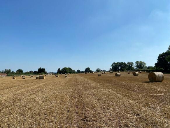
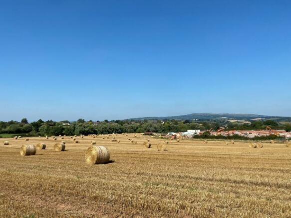
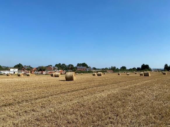
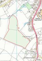
The land extends to 15.16 acres (6.14 hectares) of Grade 2 land currently utilised for agricultural cropping. The land is situated to the west of Oldwood Road and borders a site currently being developed for residential use.
ACCESS
The land is accessed from the A4112 Oldwood Road, through the adjacent residential development. A further access is provided to the south along a public bridleway. Confirmation of access through the neighbouring residential development will be provided.
LAND SCHEDULE
Parcel ID Description Area (Ac) Area (Ha)
SO5867 9823 Arable 15.16 6.14
BASIC PAYMENT SCHEME
The land is registered with the Rural Payments Agency and the Basic Payment Scheme is currently claimed. Entitlements will be made available for sale by separate negotiation.
EASEMENTS, WAYLEAVES & RGHTS OF WAY
The property is sold subject to and with the benefit of all existing rights of way whether public or private, light, support, drainage, water and electricity supplies together with all wayleaves whether referred to in these particulars or not.
SPORTING, TIMBER & MINERAL RIGHTS
In so far as they are owned, these are included within the sale.
SERVICES
Mains water is connected to the land.
TENURE & POSSESSION
The freehold of the land is being sold. There is currently a tenant occupying the land by way of a twelve-month Farm Business Tenancy which will expire on the 28th September 2022.
METHOD OF SALE
The property is offered for sale by Private Treaty.
DEVELOPMENT POTENTIAL
The land is situated to the west of Oldwood Road and sits adjacent to the development boundary of Tenbury Wells. The land lying to the east is currently being developed for residential use with access being provided along Mistletoe Row.
The land provides a good opportunity for a strategic investment in agricultural land with potential opportunity for future development, subject to the necessary planning consent being granted.
Brochures
Particulars15.16 Acres Land off Oldwood Road, Tenbury Wells, Worcestershire, WR15

NEAREST STATIONS
Distances are straight line measurements from the centre of the postcode- Ludlow Station6.7 miles
About the agent
Nock Deighton, Agricultural LLP
Old Smithfield, 34-35 Whitburn Street Bridgnorth WV16 4QN
Our business is built on trusting in exceptional people with a shared passion for living in Shropshire.
One of the Midlands’ oldest and most respected privately owned firms of estate agents, chartered surveyors and auctioneers, founded in 1831, Nock Deighton today stands at the forefront of the modern property world, embracing up-to-the-minute technology, industry best practice and a firm focus on achieving excellent results through excellent service and marketing.
With branches i
Industry affiliations

Notes
Disclaimer - Property reference O107A. The information displayed about this property comprises a property advertisement. Rightmove.co.uk makes no warranty as to the accuracy or completeness of the advertisement or any linked or associated information, and Rightmove has no control over the content. This property advertisement does not constitute property particulars. The information is provided and maintained by Nock Deighton, Agricultural LLP. Please contact the selling agent or developer directly to obtain any information which may be available under the terms of The Energy Performance of Buildings (Certificates and Inspections) (England and Wales) Regulations 2007 or the Home Report if in relation to a residential property in Scotland.
Map data ©OpenStreetMap contributors.