
Barn End Lane, Wilmington, Dartford, Kent, DA2
- PROPERTY TYPE
Land
- SIZE
12,447,270 sq ft
1,156,390 sq m
Key features
- Highly productive block of Grade II and Grade III arable land ‘inside’ the M25
- In all about 285.75 acres (115.64 hectares)
- Classified by the Cranfield Soil and AgriFood Institute as Soilscape 7 and characterised as freely draining
- Road frontage with vehicular gated access
Description
#TheGardenOfEngland
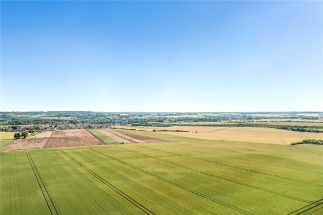
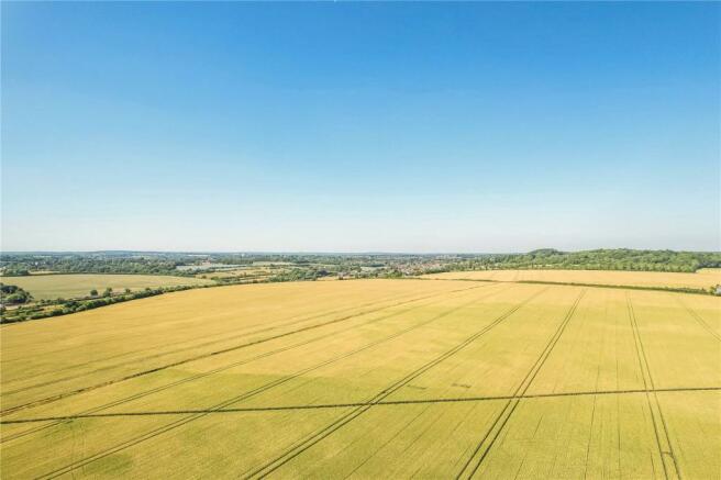
An excellent opportunity to purchase a highly productive block of Grade II & III arable farmland ‘inside’ the M25, between Dartford and Swanley.
The land is close to the villages of Wilmington and Hextable with road access.
In all about 285.75 acres (115.64 hectares).
Guide Price: £3,175,000 to £3,250,000
Situation
The land is located between the villages of Wilmington, Hawley and Hextable in north Kent, approximately 2.5 miles south of Dartford. There is easy access to the M25 and A2 from the Darenth Interchange approximately 3.4 miles northeast, and to the M20 and M25 from Swanley Interchange approximately 3.6 miles south west.
The Farmland
The land extends to an area of about 285.75 acres (115.637 hectares) or thereabouts of predominately level arable land. The land is shown as a mixture of Grade II and Grade III on the Agricultural Land Classification Map. The soil is classified by the Cranfield Soil and AgriFood Institute as Soilscape 7 and characterised as freely draining slightly acid but base-rich soils of high fertility.
The land h
as been farmed in an arable rotation, with winter wheat, winter barley, spring barley, oil seed , linseed and peas grown within the last five years. A full cropping rotation is available on request.
Method of Sale
The land is offered for sale by Private Treaty with offers invited. However, in the event of several competing bids interested parties may be asked to submit their “best and final” offer.
The seller also reserves the right to offer the land by informal tender or public auction if the need arises.
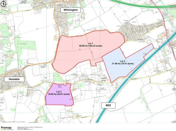
The land is offered as a whole or in three Lots as coloured on the plans produced as part of these particulars and as described herein.
Lot 1: 162.33 acres (65.693 hectares)
A significant block of level Grade II and Grade III arable land. Road frontage on three boundaries and vehicular access from Shirehall Road to the north, and Barn End Lane to the west. There is internal access to Lot 2.
Lot 2: 78.81 acres (31.891 hectares)
Two parcels of Grade II and Grade III arable land. Road frontage and access to one field from Clement Street on the southern boundary. Internal access between the two parcels and with Lot 1.
Lot 3: 44.61 acres (18.053 hectares)
A single parcel of slightly sloping Grade II arable land with vehicular gated access from Gildenhill Road on the south east corner.
Overage, Clawback, Restrictions and Uplift
All Lots are sold subject to an overage agreement for a term of 30 years with a 30% uplift triggered by planning permission or permitted development for uses other than agriculture.
Tenancy and Possession
Lot 1 is offered freehold, with the exception of the indicative area shaded blue denoting a sale of a leasehold title. The leasehold land is on a 999-year lease with approx. 959 years remaining. A small parcel of the field is unregistered although it is understood to have been part of the field for circa 50 years.
Lot 2 is offered freehold.
Lot 3 is offered leasehold. The land is on two 999-years leases both with approx 959 years remaining.
A share farming agreement has recently expired and all lots are offered with vacant possession.
Basic Payment Scheme
The land is eligible and registered to receive payments under the Basic Payment Scheme. Entitlements are available by separate negotiation if required.
Stewardship Schemes
We are not aware of any stewardship schemes upon the land.
Services
No services are currently connected to land.
Wayleaves, Easements, Rights of Way
The Property is being sold subject to and with the benefit of all rights including rights of way, whether public or private, light, support, easements and quasi easements and restrictive covenants and all existing and proposed wayleaves and easements for masts, towers, stays, cables, drains, communications, water and gas and other pipes whether referred to in these particulars or not.
Public footpaths cross Lot 1, Lot 2 & Lot 3. Plans are available on request.
Designations
The land is within the Green Belt and within North Kent Nitrate Vulnerable Zone (NVZ) 2021 to 2024.
Sporting Rights
These are included in the sale.
VAT
Any guide price quoted is exclusive of VAT. In the event that a sale of the properties or any part, or attached rights becomes a chargeable supply for the purposes of VAT, then such tax will be payable in addition.
Local Authority
All planning enquiries relating to any future planning or change of use of the land should be directed to Dartford Borough Council.
Tel: .
Website:
Photographs
Photographs were taken in June 2022.
Boundaries, Plans and Areas
The plans on these sales particulars and the acreages quoted are strictly for identification and guidance only. Interested parties are reminded that the land is sold in accordance with the owners Land Registry Title plans and must satisfy themselves as to the boundaries and the quantity of land being purchased.
The Purchaser(s) will be deemed to have full knowledge of all boundaries and any error or mistake shall not annul the sale or entitle any party to compensation thereof.
The specified areas are given for guidance only and without responsibility. Purchasers should not reply upon the stated areas as a statement or representation of fact but must satisfy themselves by inspection or otherwise.
Viewings
Strictly by confirmed appointment with Hobbs Parker on . We ask all viewers to be vigilant.
Health and Safety
Prospective purchasers must have regard for their own safety during viewings. The Vendors and their agents do not accept any responsibility for any accident or injury as a result of viewings.
Our Ref: AEA210067
Brochures
ParticularsBarn End Lane, Wilmington, Dartford, Kent, DA2

NEAREST STATIONS
Distances are straight line measurements from the centre of the postcode- Dartford Station2.0 miles
- Crayford Station2.6 miles
- Farningham Road Station1.5 miles

About the agent
Hobbs Parker Estate Agents, Ashford
Romney House Monument Way, Orbital Park, Ashford, TN24 0HB
How do you choose an Estate Agent when we all appear to offer a similar service? Well, the difference between an average Estate Agency and a very good one is essentially down to the people that work there - we have very good people at Hobbs Parker. To look after you properly we employ the best people who know your area well and have many years of experience handling all the tricky things that buying, selling, letting or renting houses can bring.
Industry affiliations


Notes
Disclaimer - Property reference AEA210067. The information displayed about this property comprises a property advertisement. Rightmove.co.uk makes no warranty as to the accuracy or completeness of the advertisement or any linked or associated information, and Rightmove has no control over the content. This property advertisement does not constitute property particulars. The information is provided and maintained by Hobbs Parker Estate Agents, Ashford. Please contact the selling agent or developer directly to obtain any information which may be available under the terms of The Energy Performance of Buildings (Certificates and Inspections) (England and Wales) Regulations 2007 or the Home Report if in relation to a residential property in Scotland.
Auction Fees: The purchase of this property may include associated fees not listed here, as it is to be sold via auction. To find out more about the fees associated with this property please call Hobbs Parker Estate Agents, Ashford on 01233 542521.
*Guide Price: An indication of a seller's minimum expectation at auction and given as a “Guide Price” or a range of “Guide Prices”. This is not necessarily the figure a property will sell for and is subject to change prior to the auction.
Reserve Price: Each auction property will be subject to a “Reserve Price” below which the property cannot be sold at auction. Normally the “Reserve Price” will be set within the range of “Guide Prices” or no more than 10% above a single “Guide Price.”
Map data ©OpenStreetMap contributors.