
RESIDENTIAL DEVELOPMENT SITE, Lowerside Lane, Glastonbury, BA6
- SIZE
Ask agent
- SECTOR
Plot for sale
Key features
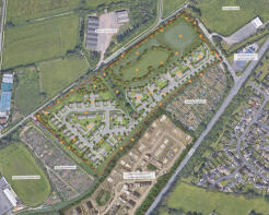
- Outline Planning Permission
- Up to 90 Dwellings
- Phosphate Credits Secured
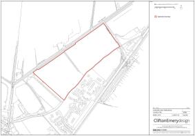
- Approximately 6.87ha (17 acres)
Description
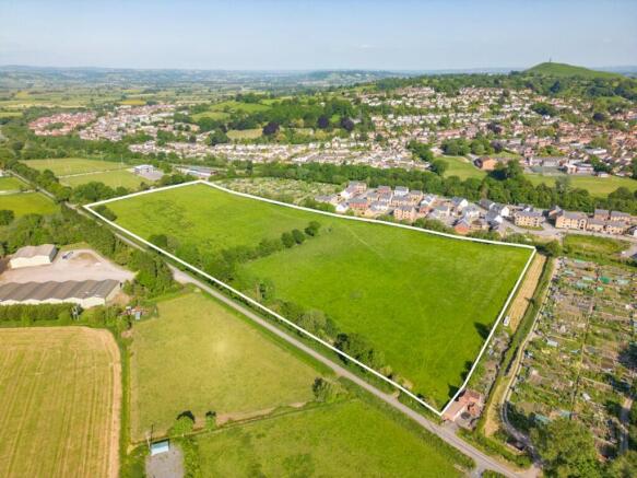
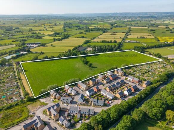
A broadly level greenfield residential development site with the benefit of outline planning permission (Ref.2021/2466/OTS) for up to 90 dwellings. The site is located on the northwest edge of the historic town of Glastonbury & extends to approximately 6.87 hectares (17 acres). It currently comprises of agricultural grass land with an access gate in the northeast corner off Lowerside Lane just off the A39 where the site access is proposed. There is another access gate in the southwest corner off Common Moor Drove. To the southeast of the site are allotments and the recent "Kingsfield" housing development, to the southwest are more allotments and to the northeast is Tor Rugby Club and a funeral directors. There are rhynes (drainage ditches) running along three of the boundaries (not the southwest) which are flanked by vegetation and trees.
GLASTONBURY
The historic town of Glastonbury is famous for its Tor and Abbey Ruins and has a good range of shops, supermarkets, restaurants, cafes, public houses and health centres. and is located circa 6 miles from the Cathedral City of Wells and the thriving centre of Street, which offers a wide range of facilities including both indoor and outdoor swimming pools, Strode Theatre and the complex of factory shopping outlets in Clarks Village. Excellent schooling can also be found locally across all ages to include Strode College which celebrates an outstanding Ofsted rating, prestigious Millfield School, Millfield Prep, Hazelgrove Prep school, Wells Cathedral, Kings School Bruton and Bruton School for Girls. Castle Cary with its main line connection to London Paddington is nearby as is the nearest M5 motorway interchange at Dunball, Bridgwater (J23). Bristol, Bath, Taunton and Yeovil are all within commuting distance.
PLANNING
Outline planning consent for the erection of up to 90 dwellings along with associated open space and infrastructure (means of access to be determined only) was granted at appeal (reference:APP/Q3305/W/22/3311900) on 11th May 2023, following refusal notice dated 27th May 2022 for Planning Application 2021/2466/OTS.
There are two associated Section 106 Legal Agreements dated 21st March 2023 which include the following:
30% Affordable Housing, of which 75% as Social Rented Dwellings and 25% as First Homes.
Healthcare Contribution of £542 per dwelling
LAP, LEAP & LEMP
Monitoring fee of £3,500
Travel Plan contributions (some of which have already been paid)
Phosphate credits have been secured for this development and will form part of the sale.
A S73 application (Ref.2024/2046/VRC) to amend the Highway access slightly was submitted on 12th November 2024, details are included within the technical pack.
TECHNICAL PACK
A technical pack including planning documents and ground reports is available from the agents. A utility service capacity assessment and service records report has been undertaken by Teignconsult and a copy will be made available within the planning and technical pack. However, interested parties should make and rely upon their own enquiries as to the availability and capacity of any services.
METHOD OF SALE
For sale by private treaty with offers invited in the region of £2,000,000.
VAT
Please note that VAT will be chargeable on the purchase price.
VIEWING
On site at any reasonable time, but in the first instance please contact the agents to make arrangements.
Brochures
RESIDENTIAL DEVELOPMENT SITE, Lowerside Lane, Glastonbury, BA6

NEAREST STATIONS
Distances are straight line measurements from the centre of the postcode- Castle Cary Station9.4 miles
Notes
Disclaimer - Property reference 881PT. The information displayed about this property comprises a property advertisement. Rightmove.co.uk makes no warranty as to the accuracy or completeness of the advertisement or any linked or associated information, and Rightmove has no control over the content. This property advertisement does not constitute property particulars. The information is provided and maintained by KLP, Exeter. Please contact the selling agent or developer directly to obtain any information which may be available under the terms of The Energy Performance of Buildings (Certificates and Inspections) (England and Wales) Regulations 2007 or the Home Report if in relation to a residential property in Scotland.
Map data ©OpenStreetMap contributors.