High Needham, Earl Sterndale, Buxton

- PROPERTY TYPE
Detached
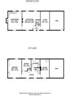
- BEDROOMS
3
- BATHROOMS
1
- SIZE
Ask agent
- TENUREDescribes how you own a property. There are different types of tenure - freehold, leasehold, and commonhold.Read more about tenure in our glossary page.
Freehold
Key features
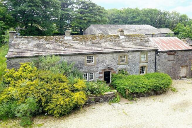
- Historic Detached Home
- Planning Consent for Extending into Attached Barn
- Additional Barns with Consent to Convert to Holiday Cottages
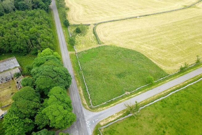
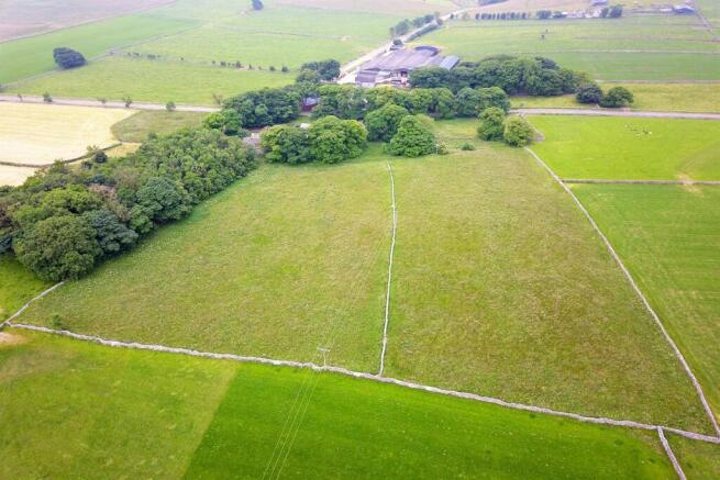
- Approximately 9.75 Acres in Total
- Woodland Area
- Grazing Land
Description
The property, thought to have been built ca. 1650 on a site dating from the 12th-century, is not listed, but is understood to be a Heritage Asset and belonged to the Chatsworth Estate until 1960. Having fallen into disrepair, the current owner purchased the property in 1990 and commenced a program of re-development bringing the property to the comfortable home it remains today. The land belonging to the house is varied and including grazing land, woodland area, gardens and an area for a market garden. A driveway sweeps around to the front of the property providing off road parking. Our vendors have stated that they may consider selling the barns with planning consent separately and keeping the main residence in the family. We therefore also welcome enquiries along those lines.
Location
The property sits within The Peak District National Park in an enviable position with the villages of Longnor and Monyash within easy reach. A little further afield the larger towns of Buxton and Bakewell provide a large range of amenities. There are various other nearby facilities including the highly rated Royal Oak, Tagg Lane Dairy as well as footpaths and trails for exploring the neighbouring countryside.
Entrance Hall
Land
TENURE
FREEHOLD Subject to Verification by Solicitors
SERVICES (NOT TESTED)
Services have not been tested and you are advised to make your own enquiries and/or inspections.
LOCAL AUTHORITY
Derbyshire Dales District Council
Planning Authority
Peak District National Park
VIEWING
Viewing strictly by appointment through the Agents.
Brochures
NeedhamGrange_CF9354Council TaxA payment made to your local authority in order to pay for local services like schools, libraries, and refuse collection. The amount you pay depends on the value of the property.Read more about council tax in our glossary page.
Band: G
High Needham, Earl Sterndale, Buxton

NEAREST STATIONS
Distances are straight line measurements from the centre of the postcode- Buxton Station6.2 miles
About the agent
Gascoigne Halman, Chapel-En-Le-Frith
27 Market Street, Chapel-En-Le-Frith, High Peak, SK23 0HP
Gascoigne Halman, which already has three offices in the High Peak, is delighted to have acquired Rowcliffes’ offices in Chapel- en- le Frith and Glossop, giving us unrivalled coverage of the local area.
When it comes to selling or letting your home, you want to know that you are working with the right team, people who have intimate knowledge of the local area and a strong track record of achieving sales and lettings, combined with a professional service that meets all of your requireme
Industry affiliations


Notes
Staying secure when looking for property
Ensure you're up to date with our latest advice on how to avoid fraud or scams when looking for property online.
Visit our security centre to find out moreDisclaimer - Property reference 935450. The information displayed about this property comprises a property advertisement. Rightmove.co.uk makes no warranty as to the accuracy or completeness of the advertisement or any linked or associated information, and Rightmove has no control over the content. This property advertisement does not constitute property particulars. The information is provided and maintained by Gascoigne Halman, Chapel-En-Le-Frith. Please contact the selling agent or developer directly to obtain any information which may be available under the terms of The Energy Performance of Buildings (Certificates and Inspections) (England and Wales) Regulations 2007 or the Home Report if in relation to a residential property in Scotland.
*This is the average speed from the provider with the fastest broadband package available at this postcode. The average speed displayed is based on the download speeds of at least 50% of customers at peak time (8pm to 10pm). Fibre/cable services at the postcode are subject to availability and may differ between properties within a postcode. Speeds can be affected by a range of technical and environmental factors. The speed at the property may be lower than that listed above. You can check the estimated speed and confirm availability to a property prior to purchasing on the broadband provider's website. Providers may increase charges. The information is provided and maintained by Decision Technologies Limited.
**This is indicative only and based on a 2-person household with multiple devices and simultaneous usage. Broadband performance is affected by multiple factors including number of occupants and devices, simultaneous usage, router range etc. For more information speak to your broadband provider.
Map data ©OpenStreetMap contributors.