Esgair Y Ffordd, Machynlleth, Mid Wales SY20
£0.14 per sq ft
Business rates & charges may apply

- SIZE AVAILABLE
10,968,414 sq ft
1,019,000 sq m
- SECTOR
Land for sale
Key features
- Esgair Y Ffordd 101.90 Hectares / 251.79 Acres
- Viewing is possible at any time, unaccompanied.
- Maturing crops, with an estimated Yield Class 16-18
- Unthinned Sitka spruce planted between 1986-1988
- Immediate harvesting available under approved Felling License
Description
* Maturing crops, with an estimated Yield Class 16-18
* Unthinned Sitka spruce planted between 1986-1988
* Immediate harvesting available under approved Felling License
* Good internal infrastructure
* Close to timber markets
* Tried and tested timber haulage route
Location
The woodlands are located approximately 5 miles to the south of Machynlleth, a market town within the Welsh county of Powys. Machynlleth offers local services, such as hotels, restaurants and a train station.
The property lies at the southern end of Mynydd Bychan Forest, owned by Natural Resources Wales (NRW). There are a number of nearby sawmills in relatively close proximity, most notably, BSW at Newbridge (40 miles), Teifi Timber products at Llanllwni (51 miles) and Kronospan at Chirk (55 miles). The grid reference to the main property entrance is from the NRW road is SN 7825 9244. The nearest postcode is SY20 8RR and the What3Words code is
///iteration.probable.pollution.
Directions and Access
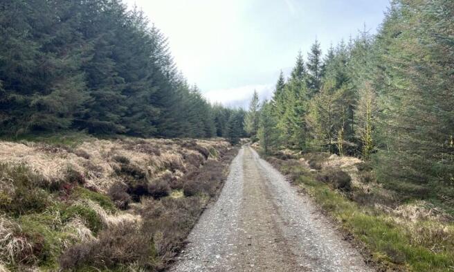
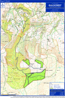
Heading east on the A489 in Machynlleth turn right onto Forge Road. Travel past the builder's merchants and continue the road for 1.4 miles to the village of Forge. Follow the tarmac road and turn right before the bridge. The forest entrance is approximately 1.5 miles from here, shown as Point A1 on the Sale Plan. Drive the tarmac road until it ends and becomes a stone forest road at point A2. At the first junction take the right hand fork uphill, shown as Point A3 on the Sale Plan. There is a right of access for management and light vehicles from A3 - A4. A secondary route for timber haulage from the property is shown as B1-B2-A3-A4 on the Sale Plan. This timber haulage route has been tried and tested, NRW have extracted significant volumes of timber using this route.
The final section of the approach to the property on the A489 public highway is not suitable for HGVs. A separate deed of easement along forest roads has been negotiated with NRW, shown as B1-B2 on the Sale Plan. The easement is a 25-year agreement and commenced on 15th May 2009, approximately £20,000 will be payable to use this route when harvesting and haulage commences. For more information, please contact the Selling Agents.
Description
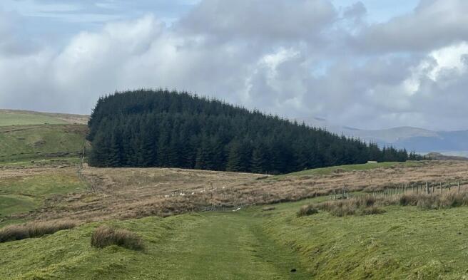
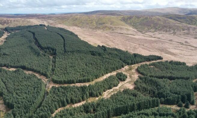
Esgair Y Ffordd is split into three distinct forestry blocks, one larger and two satellite, which are located to the south of a forest complex predominantly owned by Natural Resources Wales. The property ranges from 380m-500m above sea level and is first rotation Sitka spruce planted 1986-88. No felling has yet taken place and a new owner will have a sizeable timber reserve to harvest. There is an opportunity for a purchaser to restructure the even aged property once harvested. The spruce crops are of good form and growing well on the free draining soils and are standing at an estimated YC16-18. The stands are capable of producing quality sawlogs as well as products for the carcassing and packaging sectors. The second rotation will benefit from improved ground conditions and improved seed source, which will likely produce much higher yields. All of the areas can be harvested using wheeled/tracked machinery minimising working costs.
The open ground and scattered mixed broadleaves compliment the spruce dominated property. The owner has carried out a small area of new planting within the open ground, the young crop is now established and shows the potential of using a superior seed source in the future. There is a current Felling License ref: FLA370 21-22 which covers 10.85 hectares and expires on 6th July 2024. The species are summarised in the table below, further information is available from Goldcrest Land & Forestry Group, upon request.
The main forestry block has good access and clear areas for loading and timber stacking inside the gateway. The two satellite blocks are linked to the main area of the property by a hard track which, with some remedial work, will be suitable for timber extraction.
Boundaries
All fencing liabilities are shown with an inward facing "T" on the Sale Plan.
Wayleaves & Third-Party Rights
A water pipeline runs north to south though the main forestry block. This 20 metre strip of ground above the pipe is not within the property boundary. The owners of the pipeline has a right of access through the property A4 on the Sale Plan to access the pipeline. A neighbouring land owner also has access through the main block. A public footpath runs through the southern section the main block and out onto the open hill ground to the east. Hidden between the public footpath and the forest track lies the remains of a ring cairn, probably dating to the Bronze Age (c.2300 BC - 800 BC). This is a scheduled ancient monument and marked on the Ordnance Survey plan. For more information please contact the Selling Agents
Brochures
Esgair Y Ffordd, Machynlleth, Mid Wales SY20

NEAREST STATIONS
Distances are straight line measurements from the centre of the postcode- Machynlleth Station5.7 miles
- Dovey Junction Station6.4 miles
Notes
Disclaimer - Property reference Esgairfordd. The information displayed about this property comprises a property advertisement. Rightmove.co.uk makes no warranty as to the accuracy or completeness of the advertisement or any linked or associated information, and Rightmove has no control over the content. This property advertisement does not constitute property particulars. The information is provided and maintained by GOLDCREST LAND & FORESTRY GROUP LLP, Edinburgh. Please contact the selling agent or developer directly to obtain any information which may be available under the terms of The Energy Performance of Buildings (Certificates and Inspections) (England and Wales) Regulations 2007 or the Home Report if in relation to a residential property in Scotland.
Map data ©OpenStreetMap contributors.