Church Road, Trimdon Station, County Durham, TS29

- SIZE AVAILABLE
41,382 sq ft
3,845 sq m
- SECTOR
Residential development for sale
Key features
- Previously developed land with potential for residential development
- Located within the central area of Trimdon Village
- Predominantly brownfield land located in the centre of Trimdon Village
Description
Location
The village of Trimdon is located within the administrative area of Durham County Council. It has a population of approximately 2,958 (2011 Census).
Sedgefield is located approximately 3.4-miles to the south of the village (via the B1278), Peterlee is positioned approximately 9.4-miles to the north-east of the village (via the A181) and the City of Durham is located approximately 9.4-miles to the north west (via the A177). Junction 61 of the A1(M) Motorway is located approximately 4.5-miles, to the north west.
The village has a range of ecclesiastical, educational, cultural, leisure and shopping facilities and is well connected to nearby settlements.
Communications
Road - The site has road frontage to Church Road, to the west. In turn this road links to the B1278, which runs along the western edge of the village. The B1278 connects to Fishburn and Sedgefield, to the south and to Trimdon Grange and the A181, to the north.
Rail - Durham Railway Station (approximately 9.5 miles to the north-west) provides routes to Newcastle upon Tyne, to the north and to Darlington, to the south. The newly opened Horden Railway Station also provides coastal services between Newcastle, Sunderland and Middlesbrough.
Air - Teesside International Airport is located approximately 15.6-miles to the south. It provides scheduled and chartered flights to a range of national and international destinations.
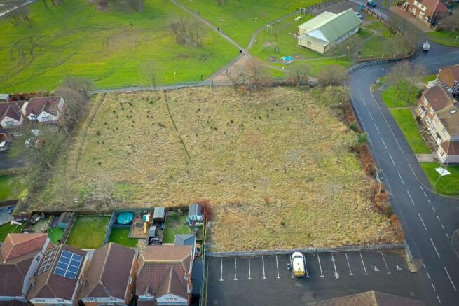
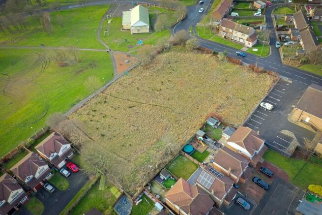
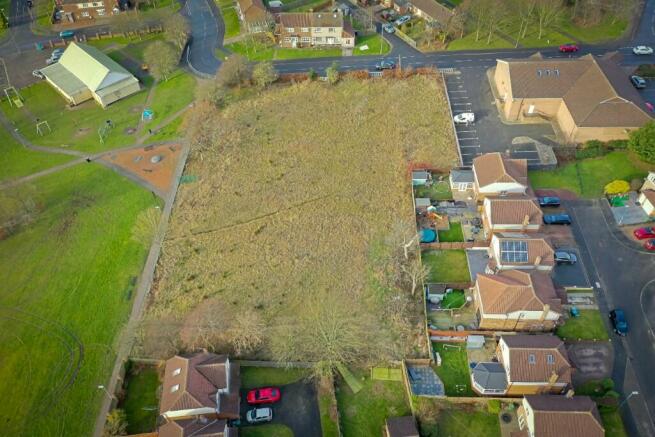
Site
The site is located within the central area of Trimdon Village. It fronts Church Street which is the central highway traversing the village. The Village Hall and associated open space is located to the immediate south of the site. Housing and the library carpark are positioned to the north, with further housing to the east.
Description
The site comprises an area of predominantly brownfield land located in the centre of Trimdon Village. The majority of the site was formerly occupied by Trimdon Village Community Infant and Nursery School, although there is also a section of undeveloped land to the east of the site which once formed the school's playground. Following the closure of the school in 2016, the old school buildings were subsequently demolished in 2017. The site is now laid to grass, is fairly regular in shape and slopes gently from west to the east, away from Church Road. A number of medium sized trees line most of the boundaries. A low-level brick wall binds the western boundary with palisade and timber fencing binding the rest of the site.
Access is available from the south and west boundaries, with a pedestrian access at the south-west corner.
Planning
For the avoidance of doubt, the site is not subject of planning permission for development. It will be the responsibility of the successful party to procure a planning permission for development.
Pre-application Advice Report
On 9th September 2020, Durham County Council Planning Team issued a Pre-application Advice Report, which details the potential for the development of the site.
The report concludes: -
'Having regard to the above, and on the basis of the information submitted to date, whilst the proposals could be supported in principle there are a number of areas where the scheme requires careful consideration before a favourable recommendation can be made. Any prospective purchasers of the land would be advised to contact the L P A with more detailed proposals for assessment and submit the necessary supporting information for detailed assessment prior to pursuing any formal submission.'
A copy of the report can be found within the Information Pack.
Nutrient Neutrality
The site is located within the Teesmouth and Cleveland Coast Nutrient Neutrality Catchment Area. Interested parties are advised to take advice prior to submitting a bid and should refer to Durham County Council's 'Submitting an Application' page for more information.
Interested parties will be required to detail their approach to Nutrient Neutrality within its tender (Submission of Offer form).
Brochures
Church Road, Trimdon Station, County Durham, TS29

NEAREST STATIONS
Distances are straight line measurements from the centre of the postcode- Horden Station5.8 miles
About Durham County Council, Durham
Durham County Council County Hall Durham DH1 5UL
Notes
Disclaimer - Property reference LandtotheEastofChurchRoad. The information displayed about this property comprises a property advertisement. Rightmove.co.uk makes no warranty as to the accuracy or completeness of the advertisement or any linked or associated information, and Rightmove has no control over the content. This property advertisement does not constitute property particulars. The information is provided and maintained by Durham County Council, Durham. Please contact the selling agent or developer directly to obtain any information which may be available under the terms of The Energy Performance of Buildings (Certificates and Inspections) (England and Wales) Regulations 2007 or the Home Report if in relation to a residential property in Scotland.
Map data ©OpenStreetMap contributors.