Land at Splash Lane, Castor
- PROPERTY TYPE
Farm Land
- SIZE
Ask agent
Description
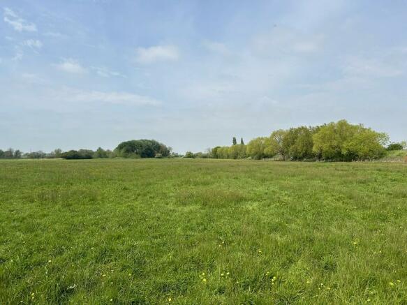
The Land at Splash Lane is located to the south of the village of Castor, approximately 0.3 miles along Splash Lane. The property lies within the district of the City of Peterborough, and within the county of Cambridgeshire. The property is approximately 5 miles from the centre of Peterborough and 3.5 miles from the A47/A1 junction, providing excellent links to major transport networks.
DESCRIPTION
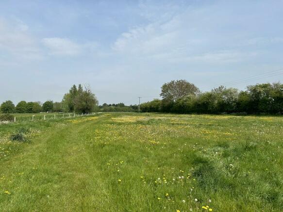
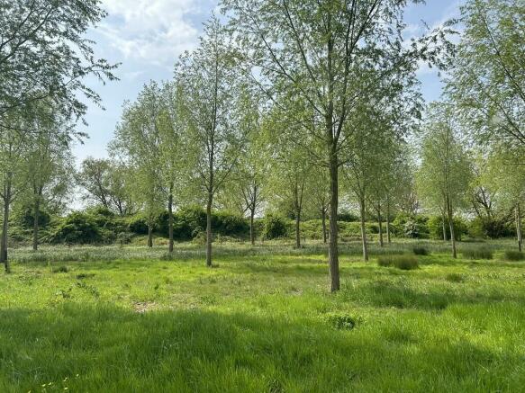
The Land at Splash Lane extends to approximately 37.46 acres (15.16 hectares) in total. The Land is split into three field parcels which are separated by the Nene Valley Railway line. The land to the north of the railway line extends to approximated 5.16 acres (2.09 hectares) of Permanent Pasture and 1.36 acres (0.55 hectares) of Cricket Bat Willow Trees. The land to the south of the railway line extends to approximately 30.94 acres (12.52 hectares) and is split into two field parcels with a small area of Cricket Bat Willows located within the curve of the ox-bow lake.
Splash Dyke runs along the western boundary of field parcel NG 4579 and continues under the railway line into Castor Linch which runs along the eastern boundary of field parcel NG 3047. The land benefits from river frontage onto the River Nene which adjoins the southern boundary of the field parcels NG 3047 and NG 8064 and has the opportunity to enjoy fishing and mooring. The Land has previously been used to graze sheep and cattle.
The Land may also be suitable for the provision of eco-system services, such as Biodiversity Net Gain, Carbon Sequestration, Re-wilding and Tree Planting.
The Land is classified as Grade 3 according to the Agricultural Land Classification of England and Wales, and the soil type is predominantly of the Sutton 1 Association, which is more commonly described as well drained fine and coarse loamy soils locally calcareous and in places shallow over limestone gravel, according to the Soil Survey of England and Wales.
ACCESS
The land is accessed directly from Splash Lane which leads off Peterborough Road in Castor. Access into field NG 4579 which provides further access under the railway bridge into field NG 3047 and NG 8064 beyond.
METHOD OF SALE
The land is offered for sale by Private Treaty as a whole.
TENURE AND POSSESSION
The land is offered for sale Freehold with the benefit of Vacant Possession on completion.
SERVICES
There are currently no mains services connected to the property.
PLANNING AND LOCAL AUTHORITY
The property is located in the administrative boundaries of Peterborough City Council.
SPORTING, TIMBER AND MINERAL RIGHTS
The sporting, mineral and timber rights are included in the freehold sale, insofar as they are owned.
ENVIRONMENTAL SCHEMES
The land is currently within a Mid-Tier Countryside Stewardship Agreement which expires on 31st December 2025 The options under the Agreement include GS6: Management of Species Rich Grassland and GS10: Management of Wet Grassland for Wintering Waders and Wildfowl. Further details are available from the Agent.
DESIGNATIONS
The land located within parcel NG 3047 adjacent to the River Nene is located within the Castor Flood Meadows SSSI. Part of parcel NG 8064 is designated as a Scheduled Monument. Further details are available from the Agent.
EASEMENTS, WAYLEAVES AND RIGHTS OF WAY
The Property is sold subject to and with the benefit of all existing wayleaves, easements and rights of way, whether public or private, light, sport, drainage, water, electricity supplies and any other rights, obligations, easements and quasi easements, whether specifically mentioned or not.
There is a Public Footpath across the land directly off Splash Lane which leads down to the railway line, and a Public Footpath along the boundary between field parcels NG 8064 and NG 3047. A further Permissive Footpath runs adjacent to the River Nene and forms part of the Nene Way.
An electricity line crosses field parcel NG 4579, with one pole located within the northern boundary hedge and five further poles located across the field. A further electricity line runs along the northern boundary of field parcel NG 8064.
VIEWINGS
Viewings of the property must be undertaken in daylight hours, on foot only, with a set of these particulars in hand. We ask that you contact the agent prior to any viewing.
NEAREST POSTCODE
The nearest postcode is PE5 7BD and the property can be found more precisely using the what3words mapping system reference of range.train.remaining
BOUNDARIES
The Purchaser(s) will be deemed to have inspected the property and satisfied themselves as to the ownership of any boundary, hedge, tree or ditch.
PLANS, AREAS AND SCHEDULES
Plans included or attached to these particulars are based upon the Ordnance Survey Maps copyright reserved. All plans are not to scale.
VAT
Should the sale of the property or rights attached to the sale become a chargeable supply for the purpose of VAT, such tax will be paid by the Purchaser(s) in addition to the purchase price.
HEALTH AND SAFETY
We ask you to be as vigilant as possible when making your inspection, for your own personal safety. It is asked that you observe any specific signage on the property.
MEASUREMENTS AND OTHER INFORMATION
All measurements are approximate. While we endeavour to make our Sales Particulars accurate and reliable if there is a point which is of particular importance please do contact Bletsoes who will be pleased to check the information for you, particularly if you are contemplating travelling some distance to view the property. Particulars prepared in May 2024.
Brochures
BrochureLand at Splash Lane, Castor

NEAREST STATIONS
Distances are straight line measurements from the centre of the postcode- Peterborough Station3.8 miles


Notes
Disclaimer - Property reference 100064003290. The information displayed about this property comprises a property advertisement. Rightmove.co.uk makes no warranty as to the accuracy or completeness of the advertisement or any linked or associated information, and Rightmove has no control over the content. This property advertisement does not constitute property particulars. The information is provided and maintained by Bletsoes, Thrapston. Please contact the selling agent or developer directly to obtain any information which may be available under the terms of The Energy Performance of Buildings (Certificates and Inspections) (England and Wales) Regulations 2007 or the Home Report if in relation to a residential property in Scotland.
Map data ©OpenStreetMap contributors.