Sandy Lane, Weston, Stafford

- PROPERTY TYPE
Land
- SIZE
977,922 sq ft
90,852 sq m

Key features
- Lot 2 — 22.45 acres (9.09 ha)
- An opportunity to purchase a block of pasture land available for sale as a whole or in two lots.
- Lot 1 — 15.81 acres (6.4 ha)
- Guide Price:
- Lot 2—Offers in the region of £185,000
- Lot 1— Offers in the region of £130,000
Description
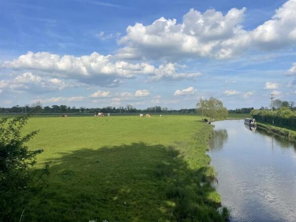
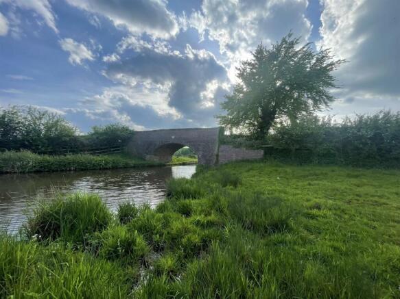
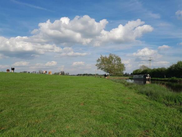
Description - An excellent opportunity to purchase Lot 2 off Sandy Lane, consisting of 22.45 acres (9.09 ha) or thereabouts of pastureland, suitable for mowing and grazing purposes. There is an opportunity to purchase Lot 1 off Sandy Lane consisting 15.81 acres (6.4 ha). The land is accessed via gateways into each lot directly off Sandy Lane. The land abuts the Trent and Mersey Canal to the southern boundary and a railway line to its northern boundary.
Location - The land is situated directly off Sandy Lane, on the outskirts of the village of Weston, Staffordshire. The land boasts close proximity to large link roads such as the A518, A51 and M6 and is in close proximity to the larger towns of Stafford (5 miles) and Uttoxeter (9.5 miles)
Directions - From the centre of Stafford, take the A518, Weston Road towards Uttoxeter, for 2.5 miles. Upon entering the village of Weston after passing Weston Hall, proceed over the river bridge and turn left onto Boat Lane, which is a short distance from the Saracens Head Public House car park (located on the right). Proceed along Boat Lane, passing over the canal bridge where it becomes Sandy Lane. The parcels of land can be accessed off Sandy Lane, before the railway. What Three Words: ///blanket.shallower.feasting
Lot 1 (Separate Listing) - Lot 1 sits west of Sandy Lane and extends to 15.81 acres (6.4 ha) being a single parcel of grassland,
suitable for grazing and mowing. The parcel can be accessed via two gateways off Sandy Lane. Lot 1 is identified edged red on the plan included.
Lot 2 - Lot 2, being 22.45 acres (9.09 ha), sits east of Sandy lane. Gayton Brook abuts the eastern boundary of the land and a mature hedgerow divides the parcel from Sandy Lane, with two separate gateways into the land. Lot 2 is divided into two parts with a gateway and sheep net fencing separating the fields. Part of the land to the east is identified as ridge and furrow on the council’s Historic Environment Record. Lot 2 is identified edged blue on the plan included.
Tenure And Possession - There is an overage clause in place for of 25% of any increase in value resulting from planning consent for
any development for a period of 25 years, excluding agricultural and non-commercial equestrian use.
The land is currently subject to a seasonal grazing licence arrangement, however vacant possession will
be offered on completion.
Sporting, Timber And Mineral Rights - The sporting rights are not included with the property. We understand the timber and mineral rights are
included as far they exist. We are not aware of any mooring rights on the canal.
Rights Of Way, Wayleaves And Easements - The property is sold subject to and with the benefit of all rights of way, wayleaves and easements whether or not they are described in these particulars.
Lot 2 is crossed by a public footpath Weston 2, which follows the route of the railway line along the northern boundary.
Services - We are not aware that any services are connected to the land.
Method Of Sale - The property is for sale by private treaty.
Solicitors - Pickering and Butters, 19 Greengate Street, Stafford, ST16 2LU .
Tel:
Local Authority - Stafford Borough Council, Riverside, Civic Centre, Stafford , ST16 3AQ.
Tel:
Money Laundering Regulations - Please note that all purchasers must provide two forms of identification to comply with the Money Laundering Regulations 2017. Proof of identification and proof of residence.
Agents Notes - Bagshaws LLP have made every reasonable effort to ensure these details offer an accurate and fair description of the property. The particulars are produced in good faith, for guidance only and do not
constitute or form an offer or part of the contract for sale. Bagshaws LLP and their employees are not
authorised to give any warranties or representations in relation to the sale and give notice that all plans,
measurements, distances, areas and any other details referred to are approximate and based on information available at the time of printing.
Brochures
Land off Sandy Lane April 2025.pdfBrochureSandy Lane, Weston, Stafford

NEAREST STATIONS
Distances are straight line measurements from the centre of the postcode- Stafford Station4.5 miles
- Stone Station6.3 miles


Notes
Disclaimer - Property reference 33302061. The information displayed about this property comprises a property advertisement. Rightmove.co.uk makes no warranty as to the accuracy or completeness of the advertisement or any linked or associated information, and Rightmove has no control over the content. This property advertisement does not constitute property particulars. The information is provided and maintained by Bagshaws, Ashbourne. Please contact the selling agent or developer directly to obtain any information which may be available under the terms of The Energy Performance of Buildings (Certificates and Inspections) (England and Wales) Regulations 2007 or the Home Report if in relation to a residential property in Scotland.
Map data ©OpenStreetMap contributors.