
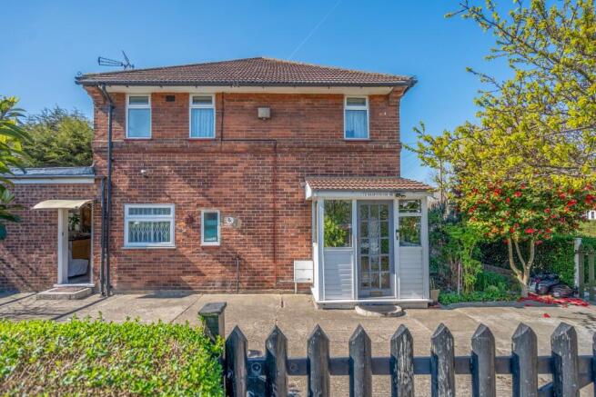

Gospatrick Road, London, N17
- PROPERTY TYPE
End of Terrace
- BEDROOMS
3
- BATHROOMS
2
- SIZE
Ask agent
- TENUREDescribes how you own a property. There are different types of tenure - freehold, leasehold, and commonhold.Read more about tenure in our glossary page.
Freehold
Key features
- Extended end terrace family home
- Three-bedrooms
- Spacious reception
- Kitchen/ breakfast area
- Conservatory
- First floor bathroom
- Ground floor Wc
- Rear Garden
- Off street parking
- Near to transport facilities and schools
Description
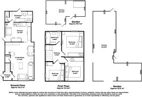
The ground floor offers a generous reception room, a modern fitted kitchen/breakfast room, a conservatory and a handy ground floor WC. Upstairs, you'll find three double bedrooms and a family bathroom. Gas central heating (untested).
The property is ideally situated for families, with Lordship Lane Primary School nearby, as well as other schooling options. Shopping facilities and amenities are within easy reach, making everyday living convenient and enjoyable.
Transport Links:
This home is perfectly positioned for commuters, with excellent transport options nearby:
* Wood Green Tube Station (Piccadilly Line)
* Turnpike Lane Tube Station (Piccadilly Line)
* White Hart Lane Overground Station
* White Hart Lane Railway Station
Nearby railway stations
White Hart Lane 1 mile
Bowes Park 1.2 miles
Alexandra Palace 1.2 miles
Bruce Grove 1.2 miles
Silver Street 1.3 miles
Palms Green 1.3 miles
Hornsey 1.4 miles
Seven sisters 1.6 miles
Northumberland Park (London) 1.7 miles
Tottenham Hale 1.8 miles
Harringay Green lanes 1.8 miles
South Tottenham 1.8 miles
Harringay 1.8 miles
Meridian water 2 miles
Stanford Hill 2.1 miles
Edmonton Green 2.1 miles
Winchmore Hill 2.2 miles
New Southgate 2.3 miles
Crouch Hill 2.4 miles
Blackhorse Road 2.5 miles
Nearest tube/DLR stations
Woodgreen tube station 0.8 miles
Turnpike Lane tube station 0.9 miles
White Hart Lane overground station 1 mile
Bruce Grove overground Station 1.2 miles
Bounds Green tube station 1.4 miles
Silver Street overground station 1.4 miles
Seven sisters tube station 1.6 miles
Seven sisters overground station 1.6 miles
Tottenham Hale tube station 1.7 miles
Harringay Green lanes overground Station 1.8 miles
South Tottenham overground station 1.8 miles
Arnos Grove tube station 2 miles
stamford Hill overground Station 2.1 miles
Edmonton Green overground station 2.1 miles
Manorhouse tube station 2.2 miles
Crouch Hill overground station 2.4 miles
Blackhorse Road tube station 2.5 miles
Blackhorse Road overground station 2.5 miles
Southgate tube station 2.5 miles
Finsbury Park tube station 2.7 miles
Nearest primary schools
Lordship Lane primary school 500 yards
The Devonshire Hill Nursery and primary School 0.6 miles
Noel Park primary School 0.7 miles
Earlham Primary School 0.7 miles
The Willow primary School 0.7 miles
Risley Avenue primary School 0.7 miles
Belmont infant school 0.7 miles
Belmont junior school 0.7 miles
Saint Michael at Bowes COFE junior school 0.8 miles
Oakthorpe primary School 0.8 miles
Nearest secondary school
Mulberry Academy Woodside 580 yards
Saint Thomas Moore Catholic School 0.7 miles
Greek secondary school of London 0.9 miles
Parkview school 1.1 miles
Saint Annes Catholic high school for girls 1.1 miles
Aylward Academy 1.2 miles
heartlands high School 1.2 miles
Dukes Aldridge 1.3 miles
Greig city canopy 1.5 miles
Laurel Park school 1.6 miles
Nearest doctor surgeries/GP practices
Westbury medical Centre 660 yards
Morris house group practice 0.6 miles
JS medical practice branch 0.6 miles
Stuart Crescent health Centre 0.7 miles
Stuart Crescent medical practice 0.7 miles
Castleview Surgery 0.8 miles
Broadwater farm medical practice 0.8 miles
Arcadian Gardens Surgery 0.8 miles
Glenoble Garden Surgery 0.8 miles
Staunton group practice 0.9 miles
Nearest dentists
Morris house dental surgery 520 yards
J Srigananathan 660 yards
Woodgreen dental clinic 0.8 miles
Demetriou 0.8 miles
Park Vue dental practice 0.8 miles
Levy Mr R 0.8 miles
Visiting specialist services Ltd 0.8 miles
Family dental practice 0.9 miles
The dental design studio 0.9 miles
Bounds green dental practice 0.9 miles
Nearest hospitals
North Middlesex University Hospital 1.1 miles
Oliver Eden hospital 1.4 miles
Saint Annes hospital 1.5 miles
Hornsey Central neighbourhood health Centre 2.1 miles
Priory Hospital North London 2.2 miles
St Luke's Woodside hospital 2.6 miles
The Whittington hospital 3.2 miles
Nuffield Health Highgate hospital 3.2 miles
Finley Memorial Hospital 3.6 miles
The Cavell hospital 3.9 miles
Nearest opticians
A Ray eye-care 530 yards
Boots Wood Green High Road 0.8 miles
S.N. Trevidi 0.8 miles
Boots optician Ltd 0.8 miles
Specsavers opticians and audiologists Woodgreen 0.9
Oprique 20:20 0.9 miles.
Ethics eye care Ltd 0.9 miles
iCloud opticians 1 mile
M.A.Heylen 1.1 miles
DH Burns 1.1 miles
All location information provided in this document, including distances and mileage, is approximate and intended for general reference only. It is the responsibility of the recipient to verify the accuracy of all location-related details, including but not limited to mileage, routes, and proximity to specific points of interest. The provider of this information does not guarantee its accuracy and assumes no liability for any discrepancies or inaccuracies.
Council Tax Band: D
Agents note: Please note that while Lastra Property Group strive to provide accurate property details, Lastra Property Group takes no responsibility for any incorrect information provided. All details should be verified by your solicitor as part of your purchase process.
Local Authority: London Borough of Haringey
- COUNCIL TAXA payment made to your local authority in order to pay for local services like schools, libraries, and refuse collection. The amount you pay depends on the value of the property.Read more about council Tax in our glossary page.
- Ask agent
- PARKINGDetails of how and where vehicles can be parked, and any associated costs.Read more about parking in our glossary page.
- Driveway
- GARDENA property has access to an outdoor space, which could be private or shared.
- Yes
- ACCESSIBILITYHow a property has been adapted to meet the needs of vulnerable or disabled individuals.Read more about accessibility in our glossary page.
- Ask agent
Get an instant, personalised result:
- Show sellers you’re serious
- Secure viewings faster with agents
- No impact on your credit score
Your mortgage
Notes
Staying secure when looking for property
Ensure you're up to date with our latest advice on how to avoid fraud or scams when looking for property online.
Visit our security centre to find out moreDisclaimer - Property reference Gospatrick. The information displayed about this property comprises a property advertisement. Rightmove.co.uk makes no warranty as to the accuracy or completeness of the advertisement or any linked or associated information, and Rightmove has no control over the content. This property advertisement does not constitute property particulars. The information is provided and maintained by LASTRA Property Group, Covering London. Please contact the selling agent or developer directly to obtain any information which may be available under the terms of The Energy Performance of Buildings (Certificates and Inspections) (England and Wales) Regulations 2007 or the Home Report if in relation to a residential property in Scotland.
*This is the average speed from the provider with the fastest broadband package available at this postcode. The average speed displayed is based on the download speeds of at least 50% of customers at peak time (8pm to 10pm). Fibre/cable services at the postcode are subject to availability and may differ between properties within a postcode. Speeds can be affected by a range of technical and environmental factors. The speed at the property may be lower than that listed above. You can check the estimated speed and confirm availability to a property prior to purchasing on the broadband provider's website. Providers may increase charges. The information is provided and maintained by Decision Technologies Limited. **This is indicative only and based on a 2-person household with multiple devices and simultaneous usage. Broadband performance is affected by multiple factors including number of occupants and devices, simultaneous usage, router range etc. For more information speak to your broadband provider.
Map data ©OpenStreetMap contributors.